




Hrádek u Třebonína Hillfort
Hrádek u Třebonína, also known as Lomec, is a medieval fortified site located about 500 meters west of Třeboň in the cadastral area of Lomec u Úmonína. Believed to have been constructed around the mid-12th century during an early phase of internal colonization in Bohemia, this site serves as a cultural monument with its remnants protected due to their historical significance. Despite limited archaeological findings, it is thought to have functioned as a defensive outpost providing refuge for local inhabitants from short-term military incursions.
The origins and historical context of Hrádek u Třebonína are shrouded in mystery due to the absence of written records directly related to its construction or purpose. It was first described by Kliment Čermák in 1883, marking the beginning of documented interest in this site. Archaeological research conducted in the 1970s by Zdeněk Smetánka and Jiří Škabrad did not yield findings that could precisely date its construction. However, based on settlement patterns and its strategic location, historians suggest it was likely built as a defensive structure during the mid-12th century to support internal colonization efforts in Bohemia.
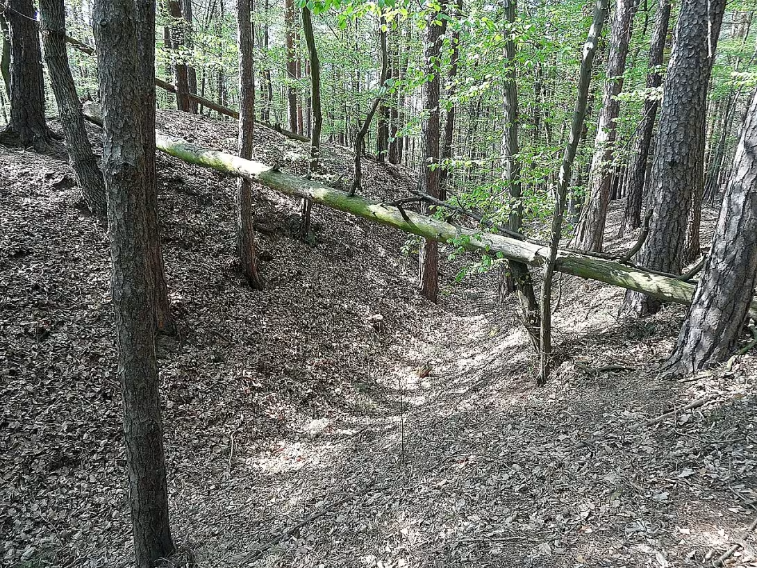
Architecturally, Hrádek u Třebonína features a multi-layered defensive system that includes an outer ditch, ramparts, and multiple walls. The site is strategically positioned on a rocky outcrop above the left bank of Medenický potok. Access to this elevated position from the east is via a narrow ravine approximately ten meters wide, while steep cliffs provide natural defense along the southern perimeter. The northern side, being more accessible, was fortified with several layers of defense, including an outer ditch measuring 76 meters in length, eight meters in width, and up to three meters deep. Beyond this ditch lies a rampart that rises five meters above its base, followed by a platform leading to a second ditch approximately five meters wide. A second rampart, about two meters wide, stands behind it, with a third, less pronounced rampart visible as a terrain ridge extending towards the south.
The site's ownership and administrative history remain largely undocumented due to the lack of written records from its time. Consequently, there are no dramatic changes or notable events tied specifically to Hrádek u Třebonína that can be detailed beyond its general role in medieval settlement defense strategies.
While specific key events at Hrádek u Třebonína remain undocumented, its strategic location near the Haberská stezka suggests it played a significant defensive role during periods of instability. Despite this potential for historical significance, no substantial artifacts were uncovered during archaeological investigations to provide further insights into its past.
Today, Hrádek u Třebonína stands as a testament to medieval fortification techniques and settlement patterns in the Středočeský region. Although much about its specific history remains uncertain, the site's preserved defensive structures offer valuable insights into the challenges faced by early settlers in Bohemia. Visitors can explore this cultural monument to gain an appreciation for the strategic considerations of medieval communities and their efforts to protect themselves from potential threats.
Hrádek u Třebonína is a fascinating glimpse into the past, offering visitors a chance to connect with the history of medieval Bohemia. Its preserved structures provide a tangible link to the strategies employed by early settlers in securing their settlements against external threats. For those interested in history and archaeology, this site offers an intriguing opportunity to explore the remnants of a bygone era and reflect on the resilience of past communities.
Architectural development
The site features a multi-layered defensive structure with an outer ditch, ramparts, and multiple walls. The eastern approach is via a narrow ravine, while steep cliffs protect the southern side. The northern side, being more accessible, was fortified with several layers of defense.
Historical events
First described by Kliment Čermák in 1883.
Archaeological research conducted in the 1970s by Zdeněk Smetánka and Jiří Škabrad did not yield findings to precisely date its construction.
Points of interest
- Despite its strategic location near the Haberská stezka, a historical trade route, no specific battles or military campaigns involving Hrádek u Třebonína have been documented, leaving historians to speculate about its defensive role during times of unrest.
- The site's multi-layered defense system was quite advanced for its time, featuring an outer ditch and multiple ramparts that would have required significant labor and resources to construct, reflecting the importance placed on fortification in medieval Bohemia.
- Hrádek u Třebonína is one of several similar sites around Třeboň, each contributing to a network of defensive structures during the mid-12th century, yet its specific function within this network remains largely unknown due to limited archaeological evidence.
- The first documented description by Kliment Čermák in 1883 sparked interest among historians and archaeologists, but subsequent excavations have yielded few artifacts, leaving much about the site's daily life and inhabitants to the imagination.
- Although no written records detail its construction or purpose, the strategic placement of Hrádek u Třebonína on a rocky outcrop suggests it was designed not only for defense but also possibly as an observation post to monitor movements along nearby trade routes.
Guide
This guide is narrated by a synthetic voice generated by artificial intelligence.
Show guide text
This text was created by artificial intelligence and has not been editorially reviewed. It may contain inaccuracies.
Welcome in front of Hrádek u Třebonína, one of the best-preserved medieval fortifications in the Czech Republic. You stand before mighty ramparts that stretch across several square meters of area. Take a look at the facade of the rampart and notice how well it has been preserved. Hrádek u Třebonína is an example of medieval architecture dating back to around the 12th century. During this time, internal colonization was developing in the Czech lands, and it is during this period that Hrádek u Třebonína is believed to have been built.
Let's move on to the historical context. Hrádek u Třebonína is located near Haberská stezka, an important trade route connecting Bohemia with Austria. Although it seems that Hrádek u Třebonína might have played a significant role in defense against invasions, historical records of specific battles or military campaigns that took place here are missing. Therefore, historians remain puzzled as to whether Hrádek u Třebonína served as a fortress or merely as a strategic point for controlling the trade route.
Now pay attention to the architectural details. Hrádek u Třebonína is remarkable for its multi-level defensive system. Your view stretches over well-preserved ramparts that protect the inner space. Take a look at how the ramparts extend in a straight line, creating a solid boundary. Also notice that the ramparts are equipped with towers, which were likely added later.
Hrádek u Třebonína is also intriguing for its unknown past. Historians continue to strive to uncover who built it and why it was constructed. Unfortunately, these questions remain unresolved. Despite this uncertainty, Hrádek u Třebonína remains an important cultural monument that offers insight into medieval architecture and the strategic plans developed here.
Allow me to invite you to further explore this unique site. Take a look at the additional details that Hrádek u Třebonína has to offer. Let your imagination bring these memories of the place to life.
Frequently asked questions
Can the monument be visited?
This is an archaeological site. Often there is little to see on the ground and the land may be private. We have not verified access.
Where is the monument?
Location: Úmonín, Středočeský kraj. The map on this page shows the exact spot.
Why is the monument protected?
It is listed in the Central List of Cultural Monuments of the Czech Republic as a cultural monument (register no. 1000140141).
Businesses nearby
Do you run a restaurant, accommodation, shop, museum, rental, wellness or other visitor service near this monument? Show yourself directly to the people heading to it — this is how they will see you in the app and on the web:
Nearby
Located near the Medenický potok and within proximity to Třeboň, the site is surrounded by natural landscapes typical of the Středočeský region. The area offers a glimpse into medieval settlement patterns in Bohemia.
Accommodation nearby
Trips and activities nearby
Guided tours, tickets and activities nearby from GetYourGuide
Affiliate link: if you buy from the partner, we may receive a commission. The price for you does not change.
Search tours and activities →Themed route
Medieval Hradec u Třebonína and its surroundings
Stop 1: Hrádek u Třebonína (hradiště) A medieval hillfort, this site offers a glimpse into the lives of Bohemian settlers from the 10th century. Explore the remains of the fortification and its surroundings.
Stop 2: Medenický potok A small stream that flows through the area, providing a serene atmosphere and a chance to observe local flora and fauna.
Stop 3: Třeboň A charming town located nearby, known for its well-preserved medieval architecture and historic center.
Seasonal recommendations
Jaro
Hrádek u Třebonína is surrounded by blooming trees and flowers in spring, creating a beautiful atmosphere. It's best to visit the site early in the morning or late afternoon during this period to avoid crowds of tourists. Good conditions for hiking and photography. Clothing: comfortable shoes and clothing suitable for hiking.
Léto
In summer, Hrádek u Třebonína is full of life. The fortress is often visited by tourists during the main summer season, so it's best to come early in the morning or late afternoon to avoid crowds. Good conditions for hiking and photography. Clothing: comfortable shoes and clothing suitable for hiking.
Podzim
In autumn, Hrádek u Třebonína is surrounded by beautiful colors of fallen leaves. The atmosphere is calm and suitable for relaxation. Clothing: attire appropriate for cold weather and comfortable shoes.
Zima
In winter, the fortress Hrádek u Třebonína is closed, but visitors can view it during the Advent period. Clothing: warm clothing and shoes suitable for cold weather.
Visualizations and artistic views


The visualisations are generated by artificial intelligence and serve as inspiration.
Photos from the area
Real photos taken near the monument


Zdroj a licence jsou uvedeny u každého snímku.
Tips from visitors
No tips yet. Be the first!
Log in and add your tip.
Sources and literature
Photos: Stribrohorak / CC BY-SA 3.0 — Wikimedia Commons. The author and licence also appear when you hover over the image.
Faktickým podkladem tohoto textu byl článek na Wikipedii, jehož autory jsou přispěvatelé Wikipedie. Článek je dostupný pod licencí CC BY-SA 4.0.
Location on the map

Příběhy a pověsti
Legendy, pověsti a příběhy spjaté s touto památkou

Fotografie návštěvníků
Zatím žádné fotografie. Buďte první, kdo přidá fotografii z návštěvy!
Log in a přidejte svou fotografii nebo hodnoťte.
Za ověřenou návštěvu v aplikaci získáte víc bodů — poznáme podle GPS, že jste na místě.
Reviews and comments