



Hradiště Na vysokém vrchu Hillfort
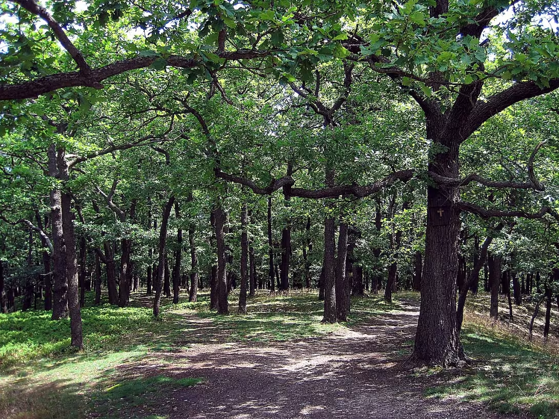
The castle in Vysoké hřích is a prehistoric fortified settlement from the Bronze Age and the younger period of the Hallatites. Located west of Little Kyšice in Kladno district. The object is a remarkable strategic position at an altitude of 489 meters and a preserved system of fortifications.
The fort was discovered in 1961 by Dr. Z. Duvet. Antonín Knor then dated him to the Halloween period. More detailed information was provided by archaeological research from 1985. On the basis of the ceramics found, the object was placed at the end of the Bronze Age and the younger period of the Hallatites. At the time of the establishment, a transition to the iron age took place in Europe. This period was characterised by the development of Halštat culture, building fortified centres and changing the social structure of prehistoric communities.
The castle area has approximately a square shape of about 1.5 hectares. There is a long bastion in the southeast corner to prevent access to the long back. The original wall was 2,75 metres wide. It consisted of the outer and inner walls of dry laid stones, whose mespivice was buried by smaller stones. No moat found. The entrance was probably on the south side near the southwest corner. Here, the two shoulders of the wall roll in and form a passage about 2.5 metres wide.
Since 1967 the site has been protected as a cultural monument. Today, the wall was preserved in the form of a wall up to six metres wide. Its height is usually about 50 centimetres, but it reaches a maximum of two meters.
During the research, eleven probes with small amounts of ceramic shards were exposed. Due to the low number of finds, it is assumed that the castle was inhabited only sporadically. Among the findings were also pebbles. These do not naturally occur on the top and probably served as slingshot ammunition.
Thanks to the altitude, the site offers a wide view of the central Bohemia landscape. The site is a valuable document of prehistoric architecture and strategic use of the terrain. Visiting this silent witness in the past helps to better understand life in the period of transition to the Iron Age.
Historical milestones
- 1961
- Discover the fort with Dr. Z. Duvet.
- 1967
- The castle is protected as a cultural monument.
- 1985
- A little archeological research.
Architectural development
The original wall was 275 centimetres wide and was made up of two walls made of dry laid stones with an inside cover of smaller stones. The entrance was on the south side of the southwest corner. Today, the wall was preserved in the form of a wall with a maximum width of six metres and a height of about 50 centimetres.
Points of interest
- The building has a strategic location at an altitude of 489 metres and offers a wide view of the central Bohemia landscape. - The castle area is approximately square in shape of about 1.5 hectares. - The original wall was 2,75 metres wide and consisted of an outer and inner wall of dry laid stones. - Found pebbles, which are not naturally present on the top, probably served as slingshots. - Due to the low number of ceramic shards found, it is assumed that the fort was only sporadically populated.
Guide
Show guide text
This text was created by artificial intelligence and has not been editorially reviewed. It may contain inaccuracies.
Welcome to High Hill. Stop for a moment and let your eyes wander freely through the landscape that is spreading before you. You are standing at an altitude of 400 to nine metres, which guarantees you an extraordinary panoramic view of Central Bohemia. This strategic position is not random. That is why, more than 3,000 years ago, people decided to live here, in this high-rise place that provided them with natural defence and control over the surrounding territory. In front of you is the site of an ancient fortified settlement known as the castle on the high hill. It lies west of the village of Malá Kyšice in Kladno district. Although it may look like a quiet, forested peak today, it is actually a place with a rich and ancient history that goes back to when there were no written records.
Let's move on to the very core of this site. The fort is approximately square and occupies an area of about one and a half hectares. Imagine a square of about 50 meters, which was once surrounded by a solid wall. This wall was not made of bricks or plastered stone, as we might imagine today a fortress. It was constructed from dry laid stones, which means that individual boulders were attached to each other without the use of mortar or other binder. The power of the entire structure consisted of the mass of the stone and its proper arrangement. The wall was approximately two and seventy-five centimeters wide, which is a rather massive dimension. It consisted of an outer and inner wall, probably filled with clay or other rock fragments to form a solid barrier. In the southeast corner of this square, there was an extended bastion, which served as a strengthened point of defense, from which defenders could better monitor the surroundings and respond to possible attacks.
When did this place become home? Archaeologists date the settlement of this castle at the end of the Bronze Age and until the younger period of the Hallatians. These are the epochs that represent a period of great change in our region, the development of agriculture, crafts and the increasing importance of defence structures. The people who lived here were probably farmers and livestock farmers who chose this place for his safety. Unfortunately, the history of this particular settlement is not entirely clear. Given the small number of archaeological findings that have been obtained here, many questions remain without a clear answer. We don't know the names of those who built it, we don't know their precise social status, or what specific events have led to the abandonment or demise of this fortified site. We are linked to the silent stone remains that remain.
The history of the discovery and research of this castle is also interesting. Although people have been on this hill for thousands of years, modern science only took note of it in the twentieth century. In 1961, Dr. Zdeněk Duřina discovered the castle. This discovery was an important step towards understanding the prehistoric settlement in this part of Central Bohemia. Six years later, in 1967, the castle was officially protected as a cultural monument. This was a crucial decision to ensure that this place did not fall into the hands of the mining industry or that it did not destroy the careless. In 1985 a small archaeological research was carried out on this site. Although it was a relatively limited event, it contributed to a better understanding of the structure of the walls and to confirming the date of settlement.
Now pay attention to the surroundings. Even though we are here in a place of such old history, today is a place of peace and quiet. You see no tall towers, no brick palaces, no statues. You see only nature that has returned over the centuries and covered the traces of human activity. Still, imagine what it would look like. Imagine the smoke rising from the fires, the movement of people in leather clothes, the proclamation of an elongated bastion. Imagine the sound of hammers hitting stone forming blocks for the wall. Imagine the life of the entire community in this square space.
One of the greatest mysteries associated with this place is its silence. Why haven't there been any more artifacts? Why does this fort seem so poor for findings compared to other similar locations? There are several possible explanations. One of them is that this was a short-term settlement, perhaps just a temporary refuge in times of danger. Another possibility is that there have been events that have led to a rapid exit without the inhabitants having been able to take their most valuable property with them. Or perhaps this is simply the result of the fact that more extensive excavation work has not been carried out here in the past. Each of these scenarios reminds us of how fragile history's memory is and how easily traces of our ancestors can be lost in time.
Despite these unknown aspects, this place has its own irreplaceable charm. It's where time seems to slow down. Where you can feel the weight of the centuries that have taken place here. Where you can appreciate the wisdom of your ancestors who chose this place for their home. It's a place that invites you to think about what's permanent and what's temporary. The wall of dry-laid stones, which once protected lives, is now a reminder that even the strongest structures can disappear over time. But the memory of them, if we keep it, lives on.
I suggest you enjoy this place in peace. No need to rush. Take a look around, listen to the wind in the trees, feel the cold air, which is often ruled by altitude. Try to imagine how this place would feel if you lived here 3,000 years ago. What would your worries, your joys, your fears? Would you be aware that you are creating a history that will be studied by archaeologists one day?
This castle is just one of many places in the Czech Republic that carry traces of prehistoric civilization. Each one has its own story, its own mystery. If you're interested in how people lived before us, how they built, how they fought back and how they adapted to nature, this place is a great beginning to your journey of knowledge. Don't be afraid to look for more information, read about the Bronze and the Halštat times, visit other archaeological sites. Every new discovery, every new discovery element helps us to write the mosaic of our common past.
Before we say goodbye, I want to thank you for having
Tips for visitors
For best experiences we recommend a visit in late afternoon. The soft light at sunset best highlights archaeological footprints in the field and helps to better imagine the original fortification of the fort.
You can reach the monument by car and public transport; check the current connection in the search engine.
Bring comfortable shoes suitable for uneven terrain and plenty of water. For photography are the best places overlooking the surrounding landscape of Kladno district, where you can capture the beauty of the historic place in a wider context.
Families with children can use a walk in the surrounding countryside to explore nature. In the vicinity of the village of Malá Kyšice you can enjoy the outdoor movement in the natural environment.
Frequently asked questions
Can the monument be visited?
This is an archaeological site. Often there is little to see on the ground and the land may be private. We have not verified access.
Where is the monument?
Location: Středočeský kraj. The map on this page shows the exact spot.
Why is the monument protected?
It is listed in the Central List of Cultural Monuments of the Czech Republic as a cultural monument (register no. 1000140175).
Businesses nearby
Do you run a restaurant, accommodation, shop, museum, rental, wellness or other visitor service near this monument? Show yourself directly to the people heading to it — this is how they will see you in the app and on the web:
Nearby
Small Kyšice village and surrounding landscape of Kladno district.
Accommodation nearby
Trips and activities nearby
Guided tours, tickets and activities nearby from GetYourGuide
Affiliate link: if you buy from the partner, we may receive a commission. The price for you does not change.
Search tours and activities →Themed route
Small Kyšice - village square * Type: * historical village centre * Why is it worth a visit: * Here you can soak up an authentic atmosphere of small-town Bohemia, get to know local architecture and prepare to climb to the castle.
Landscape around Little Kyšice * Type: * natural path * Why is it worth a visit: * picturesque field paths and vast fields offer a gradual transition over the typical landscape of the Kladno district, ideal for heating up in front of the main goal (about 2 km from the village).
Hradiště Na vysokém vrchu * Type: * archaeological site * Why is it worth visiting: * a unique primordial complex with remains of fortifications that reveals the life of the old inhabitants of Central Bohemia and provides a unique view of the history of the region.
Surrounded area * Type: * sightseeing point * Why is it worth a visit: * The panoramic view of Little Kyšice and the wider landscape of Kladno district is spread from the top, great for relaxation, photography and reflection over the landscape surrounding the castle.
Seasonal recommendations
Spring: In the spring period, Hradiště Na vysokém vrchu is revived by flowering nature, where fields and forests are colored in vivid shades of pink and blue. Sun rays penetrating through the fog give the ruins romantic lighting, which is ideal for photography. At this time the weather can suddenly be variable, so we recommend wearing layered clothes and bringing an umbrella. The best time to visit is an early afternoon when the crowds are still mild and the temperature is pleasant.
Summer: The Hradiště Na vysokém vrchu has become a popular place for visitors looking for an escape from urban life. The sun's day amplifies the colors and nature is in its greatest beauty, but there are also increasing crowds of tourists. Don't forget the sunglasses, protective quartz fabric and plenty of drinking water. It is recommended to arrive by noon to avoid the most smooth hours of the day.
Autumn: In autumn the Hradiště Na vysokém vrchu becomes melancholic and quiet atmosphere. Leaves falling from trees add color depth to the landscape panorama, while sun rays through gloom make ruins even more romantic. The weather can be variable, so it is advisable to wear a warm coat and protective quartz. The best time to visit is an early afternoon when crowds are decreasing and the atmosphere is quietest.
Winter: Winter Hradiště Na vysokém vrchu offers unique views of snow-covered ruins, which brings a magical atmosphere. The sun's rays give the snow lightning lighting and create beautiful shadows on the ground. The weather can be very cold, so it is necessary to dress in warm clothes, including hat and gloves. The opening time of the monument may be shorter, therefore we recommend to come as soon as possible after opening.
Visualizations and artistic views


The visualisations are generated by artificial intelligence and serve as inspiration.
Atmosphere of the place
This atmospheric visualisation of the place and period was generated by artificial intelligence. It is not real footage of the location.
Tips from visitors
No tips yet. Be the first!
Log in and add your tip.
Sources and literature
Photos: MartinVeselka / CC BY-SA 4.0 — Wikimedia Commons. The author and licence also appear when you hover over the image.
Faktickým podkladem tohoto textu byl článek na Wikipedii, jehož autory jsou přispěvatelé Wikipedie. Článek je dostupný pod licencí CC BY-SA 4.0.
Location on the map
Příběhy a pověsti
Legendy, pověsti a příběhy spjaté s touto památkou
Fotografie návštěvníků
Zatím žádné fotografie. Buďte první, kdo přidá fotografii z návštěvy!
Log in a přidejte svou fotografii nebo hodnoťte.
Za ověřenou návštěvu v aplikaci získáte víc bodů — poznáme podle GPS, že jste na místě.
Reviews and comments