



Modrý most Bridge
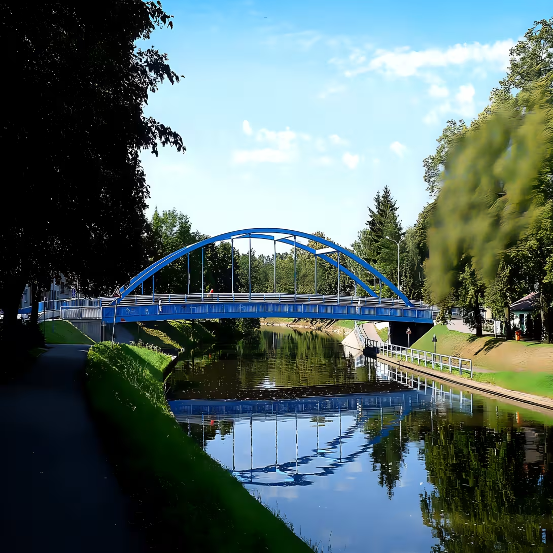
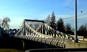
Modrý most connects Havlíček's colony with Linecan suburb and crosses the Malš River. It is a steel arch bridge of the type Langer beam with lower bridge - a construction that separates it architecturally from more common bridges. The length of the bridge is 46.2 metres, the road is 6.5 metres and there are two-metre pavements located outside the arches on both sides.
The place where the bridge stands today was originally occupied by a ferry. In 1923 it was replaced by a wooden bridge which was named Svobov's footbridge according to the then mayor of Otakar Svoboda. The bridge thus named served for decades, but in 1973 the wood was no longer a sufficient solution - the bridge was temporarily reinforced with steel construction. But this steel reinforcement lasted only three decades. In the catastrophic floods in 2002, the bridge was damaged so badly that it was necessary to dismantle it completely and build a new one. The current bridge was developed and built in 2003. He kept his characteristic color - the blue paint - and she gave the city a reason to call him Modrý most.
Although the bridge has a capacity of 22 tonnes (only up to 40 tonnes), restrictions have been present since the beginning. The operation was limited to vehicles up to 3.5 tonnes. Originally, the bridge was designed exclusively for pedestrians and cyclists. However, there was an adjustment in 2007 - the bridge was tried for one-way car operation. Later, this regulation was transformed into two-way traffic, causing a wave of protests from local residents. Citizens from the surrounding area, concerned by growing traffic and noise, founded the citizens' association Modrý most and sued the city. Their efforts were successful - the association succeeded in objecting to exclusion from the building process. As a result, the bridge for car transport was closed in July 2011.
The lockdown lasted less than a year. In June 2012, the bridge was opened again for car traffic, but this time under new conditions - a time limit was introduced. From 10 a.m. to 6 a.m., car closures are valid on the bridge. This solution represents a compromise between transport needs and the quality of life of local people.
Then and now
Drag the slider to compare how the landmark may have looked when it was built with the view today.
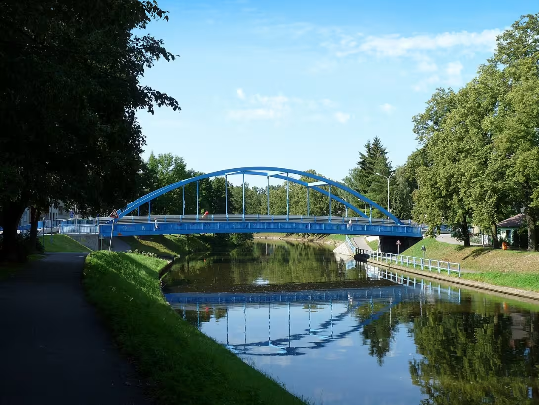

The historical appearance on the left is an AI-generated visualisation and serves as inspiration only.
Historical milestones
- 1923
- Building a wooden bridge called the Svobov footbridge.
- 1973
- Provisional reinforcement of the bridge by steel construction.
- 2003
- Completion of the construction of the current steel bridge.
- 2012
- Restoring the car bridge with time limitation.
Architectural development
A wooden bridge was established at the site of the original ferry in 1923, which was reinforced by steel construction in 1973. The current bridge from 2003 is a steel arc beam with a length of 46.2 m and a width of 6,5 m. The construction includes two-sided two-metre pavements outside the arches.
Historical events
In 2002, the original bridge was destroyed by floods, which led to the construction of a new building. In July 2011, the bridge was closed for cars after the successful action of the civil society association Modrý most.
Points of interest
- The bridge is a steel arch type of Langer beam with a lower bridge, which makes it architecturally different from more common bridges. - The site of the bridge was originally a ferry and later in 1923 a wooden bridge called Svobov's footbridge. - The name Modrý most comes from the characteristic blue paint construction. - The current bridge was originally designed exclusively for pedestrians and cyclists. - Due to the protests of the residents and the successful lawsuit, the bridge for cars has been closed from June 2012 in the morning between 22nd and 6th.
Guide
This guide is narrated by a synthetic voice generated by artificial intelligence.
Show guide text
This text was created by artificial intelligence and has not been editorially reviewed. It may contain inaccuracies.
Welcome to České Budějovice, in the heart of South Bohemia. Stop for a moment and feel the atmosphere of this place with a deep breath. You are standing in front of one of the local architectural dominants, which many of us know simply as Modrý most. Look ahead. The dominant feature of the entire space is this distinctive steel structure, which easily overlaps the surface of the river Malš. The first thing you're interested in is the rich, characteristic blue color that gives the bridge its name while creating an interesting contrast with the surrounding greenery and the grey streets. This bridge is not only a transport construction, but an important combination of two parts of the city, Havlíček colony and Linecky suburb. Imagine how many thousands of people pass and pass through here every day without realizing how many stories have happened in this place over the last decade.
Now let's go back in time together to understand why today's bridge looks just like this. The history of this place is a story of constant transformation and an attempt to overcome the water barrier that Malš represents. Even before any solid construction stood here, the inhabitants were served a simple ferry. Imagine those times when people had to rely on a ferryman to cross over. Over time, however, the city's needs grew and in 1923 the first major change took place. At that time a wooden bridge was built, which was named Svobov's footbridge. It was a construction of its time which, while fulfilling its purpose, wood is a material prone to wear and weather. At that time, the Freedom Bridge was a symbol of modernization and accessibility, but as it turned out, time and natural erosion began to take their toll.
In 1973 it became clear that the original wooden construction was no longer sufficient and its safety was compromised. Instead of a complete overhaul, a provisional solution was chosen. The bridge was reinforced with steel elements to ensure stability and enable further operation. It was kind of a transitional era when old wood met new steel. This situation lasted until one of the most tragic moments in the region's modern history. In 2002 came devastating floods, which left deep wounds in České Budějovice. The water mass of the river Malš was so strong that it simply destroyed and took away the original bridge. There was a void and a broken connection between two parts of the city. But it was from this disaster that the current building was born.
Now look again at the bridge before you. What you see is the result of a quick and effective recovery. The current steel bridge was completed in 2003. It was designed to be more resilient, more stable and at the same time aesthetically attractive. Pay attention to its architecture now, because Modrý most is not an ordinary bridge. If you look at its shape, you'll notice it's not a simple plane. The construction is made as a steel arc bridge of the type Langer beam with lower bridge. This technical title may sound complicated to you, but in practice, it means that the main load bearing force is transferred through the arc structure, while the road and pavement, the bridge itself, are located under this arc. This specific construction is less common in our region, which makes the bridge an architecturally interesting element that deviates from a number of ordinary concrete or steel bridges.
Notice how steel elements connect and how rhythmically they lead from one bank to another. The entire surface is protected by the blue coating, which is not only an aesthetic supplement, but is used primarily to protect metal against corrosion and due to moisture from the river. It is a fascinating example of how a functional engineering work can also be a visual symbol of the location.
Speaking of the history of this place, we can't forget the names of the personalities that were associated with it. Although the authors of the current bridge remain anonymous, the name Otakara Liberty remains in the memory of the local people. It is with him that the original Svobov footbridge from 1923 is connected to. It is symbolic that even though the wooden structure itself has long since disappeared in the streams of flood waters, the name of the man who helped connect the banks of Malš for the first time in modern times still resonates in local stories. It is a reminder that every new building is based on the earlier ones and that progress is the result of the work of many generations.
Maybe you're wondering how the bridge is used today. After its completion in 2003 it served as a key artery, but in 2012 there was further modification. The bridge was reinstalled for car transport, but with a certain time limit. This means that the city is trying to balance the needs of drivers with the needs of pedestrians and cyclists to keep quiet in the surrounding neighborhoods.
Here's one interesting thing that will help you see the bridge in a broader context. Think about the journey this place has taken. From a simple wooden vessel, to a wooden bridge, to steel reinforcement, to today's modern arch beam. It's basically a shortened history of technical developments in our city. Modrý most is thus in many symbols of resistance. He overcame the destruction by flooding and returned to the landscape in a form that is stronger and more beautiful. The blue color that gave him his name became more than just paint in the locational context. It's become an orientation point. When someone in Budejovice says they're meeting at the Blue Bridge, everyone knows exactly where to go.
I now invite you to slowly embark on a journey across the bridge. Can you feel the mild cold rising from the river Malš? Look under your feet at the bridge and then up again at the steel arches that accompany you. Feel the rhythm of the steps and the sound of traffic that is reflected from the steel elements. Try to imagine how you would feel in 1923, when you would walk on the wooden boards of Svobov's footbridge and hear the wood squeaking under your feet. It is fascinating how the same space can change so dramatically over the centuries and yet remain an equally important point in the life of the city.
When you cross over, I suggest you stop for a moment and look back. From this perspective you will see the entire line of the bridge and its harmony with the surrounding terrain. Modrý most is proof that a purely technical building can have a soul if it is linked to the fate of people and the history of the place.
Thank you for spending a moment with us on this interesting connection between two shores. You can now continue to explore the beautiful streets of Havlíček's colony or head for Linecky suburb. We wish you a pleasant walk and many other discoveries in our beautiful city. Goodbye.
Tips for visitors
The best time to visit is spring or autumn, when the weather is pleasant and the light on the bridge is soft, allowing comfortable walking and photography. In the summer months there may be more people around the bridge, so if you prefer a quieter atmosphere, choose earlier morning or late afternoon. Parking and transport: The bridge is easily accessible by car - public parking is nearby in Havlíček Colony and in Linecký suburb. For visitors using public transport bus stops are available in both parts of the city; Check the current connection in the traffic search engine. What to take with you: We recommend comfortable shoes suitable for uneven surface, umbrella or raincoat, a bottle of water and possibly a map or a mobile phone with an offline map to easily navigate the area. Photography - the best places and light: Ideal shots can be obtained from the banks of the river Malš, where you can catch reflections of the bridge in the water. Sunset provides warm gold light that highlights the blue color of steel. From the perspective of Havlíček Colony you will get an interesting contrast between historical buildings and the modern bridge. What to visit in the area (within 30 minutes): Walk along the river Malš will lead you to picturesque shores and local cafes. In Havlíček colony you will find historical houses and a smaller park where you can relax. In Linecký suburb there are shops and restaurants where you can taste local specialities. Tips for families with children: There is a children's playground in Havlíček Colony where children can play under supervision. The bridge is safe for both pedestrians and cyclists, but it is good to track traffic signs. In the area there are suitable places for picnic and short trips along the banks of the river, which children enjoy.
Frequently asked questions
Is Modrý most open to the public?
Yes, it's open all year round. The best time to visit is in the morning or evening when the light is ideal for photography.
How do I get to the place by car / public transport?
By car: you will find a parking lot near the bridge. Public transport: The nearest bus stops is buses 26 and 51, which is about 10 minutes walk from the bridge.
How much is the entrance fee and is it paid on the spot?
The entrance is free.
Is the tour suitable for children and seniors?
Yes, suitable for all ages. You can also find a playground near the bridge.
How long does the tour take?
You can take a tour at any time and it takes about 15-30 minutes.
What are the opening times and booking is required?
Open all year round, no restrictions. Reservation is not necessary.
What's interesting in the immediate vicinity?
In the vicinity you will also find other historical monuments and parks such as the park Štvanice or St. Ludmila church.
For kids
Imagine going back to the past. It's summer and the sun shines high in the sky. You have an amazing view of the river, which has flowed as well as today. But now there's something that looks very different - Modrý most.
It was one of the biggest bridges in Europe, and people really loved it. It was assumed that up to 500 people passed through it every day. That was a lot! So what did it look like? On one side of the river stood a great fortress with walls and towers. There was also a church where people went to pray for good weather and crops.
Businesses nearby
Do you run a restaurant, accommodation, shop, museum, rental, wellness or other visitor service near this monument? Show yourself directly to the people heading to it — this is how they will see you in the app and on the web:
Events nearby
Zdroj akcí: otevřená data měst a obcí ČR (Národní katalog otevřených dat) a kalendář akcí Národního památkového ústavu.
Nearby
The river Malš, Havlíček colony and Linecka suburb within the city České Budějovice.
Accommodation nearby
Trips and activities nearby
Guided tours, tickets and activities nearby from GetYourGuide
Affiliate link: if you buy from the partner, we may receive a commission. The price for you does not change.
Search tours and activities →Themed route
1. Havlíček colony, district: Explore interesting architecture and peaceful atmosphere of this part of town. It's the perfect place to start the journey. 2. Linecan suburb, urban area: Discover the characteristic building and alleys of this edge. This area offers a view of the local urban structure. 3. Malš River, Water Flow: Enjoy a view of flowing water and a peaceful flow. The water element gives the path a pleasant touch. 4. Modrý most, landmark: The main destination of the trip, which immediately captures its distinctive colour. It's an unmistakable point in this location.
Seasonal recommendations
Spring: In the spring season Modrý most in České Budějovice turns into an attractive place with a cozy atmosphere and warm sunlight that increases its historical beauty. Flowers begin to bloom on both sides of the bridge, creating a pleasant color contrast to the blue colour of stone arches. This is the perfect time to visit because the crowd quantity is still relatively low and you can enjoy the quiet moments on the bridge. It is recommended to wear light clothes with the possibility of adding top clothing because temperatures can change quickly. The best time to visit is in the morning or late afternoon when the sun is conveniently placed and the atmosphere is calm.
Summer: For years, Modrý most becomes the center of urban life with full energy and warm summer sunlight, which highlights its architectural details. This season the bridge often becomes a place for various outdoor events and meetings, which increases the attractiveness of visitors. However, with the arrival of summer weather, the likelihood of large crowds is also increased, especially in the main summer season. It is advisable to visit the bridge earlier in the afternoon and wear light clothes with sun protection such as hats or scarves. It is also interesting to use the colder morning or evenings to walk and enjoy the peace of the bridge.
Autumn: In autumn Modrý most becomes melancholic atmosphere with fine lighting that creates a romantic mood. Leaves on trees are colored and fallen, which adds a color element to the bridge image. This is the perfect time for quieter walks without large crowds that are typical of other seasons. Dress in warm clothes with top clothes because autumn weather can be cold and wet. The best time to visit is usually morning or evening when the temperature is more pleasant and the atmosphere calmer.
Winter: Winter brings a specific atmosphere on the Blue Bridge with cool lighting that highlights its historical architecture. During winter, local areas are likely to cover themselves with snow, creating a beautiful and almost magical view. The opening times of the monument may be shorter due to winter conditions, so it is important to check the current information before visiting. This season it is recommended to wear warm clothes and high heels, especially if you plan to walk on snow or ice. The best time to visit is usually the forefront when the temperature is milder and the sun rays can illuminate the bridge in beautiful light.
Visualizations and artistic views


The visualisations are generated by artificial intelligence and serve as inspiration.
Photos from the area
Real photos taken near the monument


Zdroj a licence jsou uvedeny u každého snímku.
Atmosphere of the place
This atmospheric visualisation of the place and period was generated by artificial intelligence. It is not real footage of the location.
Tips from visitors
No tips yet. Be the first!
Log in and add your tip.
Sources and literature
Photos: Jitka Erbenová (cheva) / CC BY-SA 3.0, rozlišení zvýšeno umělou inteligencí — Wikimedia Commons. The author and licence also appear when you hover over the image.
Faktickým podkladem tohoto textu byl článek na Wikipedii, jehož autory jsou přispěvatelé Wikipedie. Článek je dostupný pod licencí CC BY-SA 4.0.
Location on the map

Příběhy a pověsti
Legendy, pověsti a příběhy spjaté s touto památkou
Fotografie návštěvníků
Zatím žádné fotografie. Buďte první, kdo přidá fotografii z návštěvy!
Log in a přidejte svou fotografii nebo hodnoťte.
Za ověřenou návštěvu v aplikaci získáte víc bodů — poznáme podle GPS, že jste na místě.
Reviews and comments