



Osobovská skála Housing estate
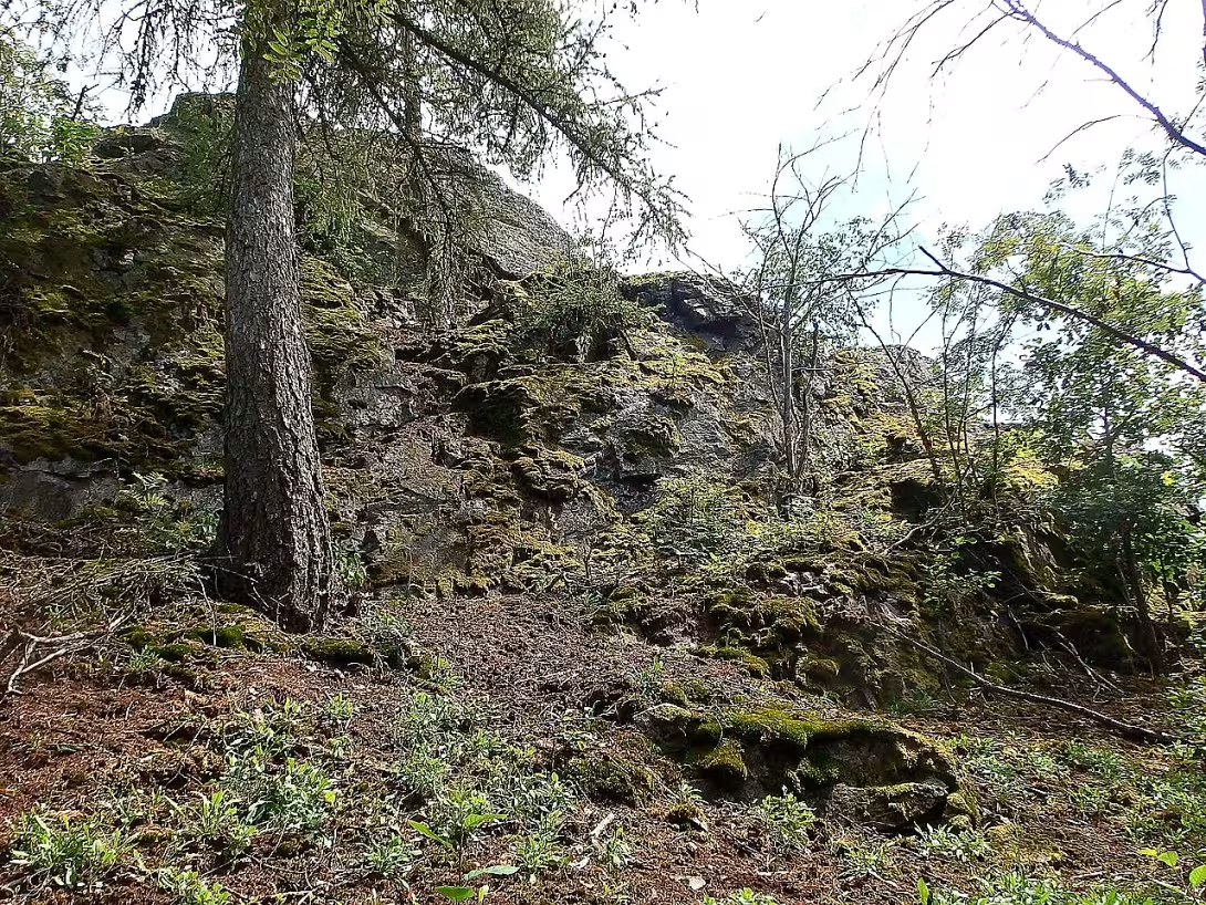
Osobovská skála is a rock top and archaeological site north of the village of Mansova near Měčína in Klatovy district. This site is important as a place of middle eneolite, where the settlement of the Champ culture was located, and is protected as a cultural monument.
The site was populated between 3100 and 2800 B.C., which was the time of key changes from hunting-based lifestyle to the first forms of agriculture. This era was characterised by the development of new technologies such as crop cultivation and ceramic production.
The location lies on a bullion rock with access only from the north and west. The peak formed by the cornea with the insert of the bulizník is part of the blemish confluence of neoprotezoic shale and crumb. Geographically they belong to Švihovský Highlands, Radyn Mountains and Bukohorská Highlands. The rock upper reaches a height of 20 meters with traces of freezing ripening. The terrain is chipped, forming several narrow platforms one to two metres wide. At least one living structure was found on the estate with dirt-covered walls.
The site was discovered in 1976, first explored a year later and again in 2006. Archaeological studies have confirmed the population's agricultural lifestyle through pollen analyses and crop findings such as wheat, flax and peas. On the basis of a comparison with the Bavarian site, cattle and horses are expected to be kept. Many artifacts were moved by erosion to the foot of the rock.
Today, Osobovská skála is protected as a cultural monument, which makes it an important place to understand the early agricultural processes in the region. It is a place worthy of visiting anyone who is interested in ancient history and natural attractions.
Historical milestones
- 3100-2800 b.c.
- The settlement of the place by the people of the Champ culture
- 1976
- Discovering archaeological sites
- 1977
- First scientific examination of the site
- 2006
- Re-archeological exploration of the site
Historical events
- 1976
- The site on the Mankind Rock has been discovered.
- 2006
- There's been further research on the estate.
Points of interest
- Osobovská skála is a rock top and archaeological site north of the village of Mansova at Měčína. - This location is important as a central eneolite site where the settlement of the Champ culture was located. - The settlement was settled between 3100 and 2800 B.C., which was the time of key changes from a hunting lifestyle to the first forms of agriculture. - The site was discovered in 1976, first explored a year later and again in 2006. - Today Osobovská skála is protected as a cultural monument.
Guide
Show guide text
This text was created by artificial intelligence and has not been editorially reviewed. It may contain inaccuracies.
Welcome to Person Rock. You are standing in a place that at first sight can act as a simple, rocky peak, protruding over the surrounding landscape. But please stop for a moment and feel the atmosphere. Look around you, at the rough shapes of rocks and the horizon, where the landscape stretches towards the village of Man. Can you feel the calm and the invisible weight of the time that's hanging in the air? It's not just an ordinary mountain. It is a place that served as a home, as a solid base and as a witness to the beginnings of human civilization in this region.
Now pay attention to what's right under your feet. This rock on which this rocky hill stands is made up of a bullion. It's a solid, durable rock that's been here for millions of years. This natural property, this unwavering fortress of rock, was crucial to the people who chose this place thousands of years ago. Let us now move together in time deep into the past to understand why this place is so special.
We are in the period of what experts call medium eneolite. For you, it may be a word less familiar, but imagine it as a fascinating bridge between old time, when people used only stone tools, and a new time when metal began to appear, namely copper. It was a time of great change when people began to settle down more, when they began to control their countries better and when their world began to change faster than ever. It was in this period, approximately between thirty-one hundred and twenty-eight hundred years before our current number of years, that a group of people we now call the Champ culture lived here.
Notice how strategically located this place is. The site of the Champ culture found here was no great city or fortified fortress. It was a small agricultural estate. Imagine these people building their simple houses here, taking care of their crops and using the protection provided by these rocky seats. They lived in close harmony with the rhythm of nature and used every advantage this rocky peak offered them. The rock was not an obstacle, but it was their protection and the foundation of their existence.
Even if you don't see the ruins of houses or stone walls here today, try to imagine their presence in spirit. The architecture of this place was not made up of decorated columns or high towers, but rather of the ability of the human hand to adapt to the harsh nature of the lumpy rock. The estate was directly built into this rock, using its shapes and providing people with safety. What you see now is only the remnants of nature, but beneath the layers of earth and stone is still hidden the story of their everyday life.
You may be asking how we learned about this place in the first place. The story of the Mankind Rock as an archaeological site is not thousands of years old, but its discovery is relatively recent. Only in the year one thousand nine hundred seventy-six was this place rediscovered. It was a surprise that opened the gate to understand the ancient history of this region. The following year, in the year one thousand nine hundred seventy-seven, there was the first actual scientific examination. Archaeologists came up with brushes and brushes to carefully uncover the traces left by the people of the Champ culture. And to ensure that we don't know too little about anything, there was another thorough archaeological examination in two thousand and six. Each of these investigations has brought us a piece of the puzzle that can bring this history together today.
There is no famous figure, no king, or a great warlord we can tell legends about. Yet the people who lived here are extremely important to us. These are the unknown farmers, the silent builders of our society. Their story is the story of people who were not afraid to face the unknown, who were able to make room for their lives and their families from hard rock and inhospitable land. It is their diligence and ability to adapt to the world of copper and stone that is the essence of this place.
Something that might interest you is the constant mystery surrounding this place. Even though we know that there was an agricultural estate, even if we know the time of their presence, there are still many questions that remain unanswered. What else is deep beneath the surface of this lumpy rock? What exactly did their instruments look like, what circuits of their paths between rocks and forests? Every stone you see here could once have been part of someone's home or tool. This rock is not just a dead stone, it's a book that is still unwritten and that scientists and we all still read in part.
Now that you've learned more about what happened here thousands of years ago, I suggest you continue your search. Take a walk around, see the texture of the rock and watch the landscape change according to where you go. Osobovská skála offers you not only a view of beautiful nature, but above all an opportunity to meet people who lived here at a completely different time than we know.
Thank you for spending this moment with us and for trying to look into the past of this place. We wish you a nice walk and many other interesting discoveries in the surrounding countryside. We'll say good-bye, but the history of Mankind Rock remains alive, ready to be rediscovered.
Tips for visitors
It is best to choose a dry period for visiting the Mankind Rock, ideally in spring or autumn, when vegetation does not obstruct the view and the terrain is better viable. The place is located in nature north of the village of Mansova near Měčína, in Klatova district.
Take your fixed shoes to nature for the journey, because it is a rocky hill and an archaeological location. We also recommend packing snacks, drinking water and a small telescope for observing the surrounding countryside.
For shooting this rocky hill and remnants of a small agricultural settlement of the Champ culture, the morning or late afternoon hours are best suited when the sunlight creates nice shadows on rock formations. The main interesting thing is to look at the place where people lived in ancient times.
Since there are no other recommended places in our background, focus your discovery directly on the natural beauty and history of the rock body itself and its immediate surroundings.
When taking a trip with children, take care to be more careful on the rock surface, which may be slippery. You can tell children about the ancient people who lived here a long time ago on the farm estate and left traces.
Frequently asked questions
Can the monument be visited?
This is a structure in a public space that can usually be seen from outside free of charge. We have not verified that this particular one is freely accessible.
Where is the monument?
Location: Měčín. The map on this page shows the exact spot.
Why is the monument protected?
It is listed in the Central List of Cultural Monuments of the Czech Republic as a cultural monument (register no. 1000127965).
Businesses nearby
Do you run a restaurant, accommodation, shop, museum, rental, wellness or other visitor service near this monument? Show yourself directly to the people heading to it — this is how they will see you in the app and on the web:
Nearby
🏰 Historic sites (98)
- Pomník obětem světových válek 2.4 km
- Pomník obětem 1. světové války 2.5 km
- Zámek Žinkovy 3.1 km +420770330328 web
- Oběti 1. sv. války 3.2 km
- Potštejn 3.6 km
- Zřícenina hradu Potštejn (Potenštejn) 3.6 km
- Pomník padlých v 1. světové válce 3.8 km
- Svatý Jan Nepomucký 4.0 km
- Zámek Měčín 4.1 km
- Pomník padlým v 1. světové válce 4.4 km
- Tvrz Němčice 5.4 km
- Padlým vojínům jarovským 5.8 km
- sv. Jan Nepomucký 6.9 km
- Pomník obětem 1. světové války 6.9 km
- Husický manifest 7.1 km
- Starý zámek Mecholupy 7.5 km web
- Zámek Újezd 7.5 km
- Pomník obětem 1. světové války 7.5 km
- Svatý Jan Nepomucký 7.8 km
- Nakloněný obelisk, památník amerických letců 8.2 km
🍽️ Restaurants and dining (78)
- U Zlatého jelena 2.4 km
- Bistro Zámek Žinkovy 3.1 km
- Hospoda na koupališti 4.0 km +420776014538
- Restaurace Koliba Nový Rybník 5.5 km
- Hospoda u Kaiserů 5.6 km +420 773 446 161;+420 773 830 940 web
- Občerstvení na koupališti Letiny 5.9 km +420731390745
- Hospoda Jarov 5.9 km
- Angusfarm Soběsuky 6.9 km Soběsuky 9 +420 724 744 740 web
- Viet Sen Restaurace 8.8 km Plzeňská 159 +420702050142
- Hospůdka Klášter 8.8 km +420 733 602 020
- Hospoda U Stadionu 8.9 km +420737956515
- Švejk restaurant U Zeleného stromu 8.9 km náměstí Augustina Němejce 69 +420 371 580 371;+420 608 002 905 web
- cukrárna 8.9 km
- Restaurace "Pod Pyramidou" 8.9 km
- Kavárna Zelenohorská pošta 9.0 km Zelenohorská 76
- Kavárna Zelenohorská pošta 9.0 km Zelenohorská 76 +420776567635 web
- LM CAFE 9.2 km U Sokolovny 308 +420724707610
- Stop Cafe 9.2 km
- Sokolovna Nepomuk 9.2 km U Sokolovny 308 +420373700968 web
- U Kubátů 9.3 km
🏨 Accommodation (20)
- Ubytování Žinkovy U Zlatého jelena 2.4 km Žinkovy 29 +420 705 001 426 web
- Středisko Letiny 4.8 km +420 775 552 922 web
- Nový Rybník 5.3 km
- Kemp Nový rybník 5.5 km +420371591336 web
- Hotel U zeleného stromu 8.9 km
- Pivni 8.9 km
- Pension S 9.0 km Husova 140 +420602452948 web
- Motel Pyramida Nepomuk 9.2 km +420702046398 web
- Statek česká lípa 9.4 km
- Švihovský dvůr 12.5 km nám. Dr. E. Beneše 200
- Švihovský dvůr 12.5 km nám. Dr. E. Beneše 200
- Panský dům 12.7 km +420371594796 web
- relax areal 13.6 km web
- Penzion U Jezu 13.8 km +420 603 252 249
- Václav Král - ARVEX 13.8 km +420 602 421 866
- Hotel Volf 13.8 km
- U Franty 14.2 km Poděbradova 393 web
- Rozvoj 14.6 km +420 376 311 609 web
- Rozvoj 14.6 km +420 376 311 609 web
- Beránek 15.0 km +420 376 312 348;+420 604 285 942 web
🚲 Rentals and sport (9)
- Městská sportovní hala 9.1 km U Sokolovny 565 web
- TJ Sokol Blovice 12.4 km
- Velovis 12.7 km
- CYKLO SPORT KABÁT 12.9 km Americká 46 +420728356003 web
- Biotop Blovice 13.6 km
- sportovní hala 14.3 km
- Tělovýchovná jednota Zdemyslice 14.8 km +420731185637 web
- Cyklosport-pitstop.cz 14.9 km
- Jizdni 15.0 km
🥾 Hiking and nature (129)
- V Držalech 0.7 km
- Ledvina 1.0 km
- V Korunách 1.9 km
- Srdce Plzeňského kraje 2.2 km
- Chlumec 2.8 km
- Rampich 3.0 km
- Čihátka 3.2 km
- Poudřim 3.2 km
- Na Smetu 3.6 km
- Buč 3.7 km
- Stará Pec 4.0 km
- Holý vrch 4.8 km
- Bejkovna 5.0 km
- Chroustov 5.0 km
- Na Starcích 5.1 km
- Hůrka 5.4 km
- Novoveská draha 5.4 km
- Hůrka 5.5 km
- Luh 5.7 km
- Dus 5.9 km
Accommodation nearby
Themed route
Thematic cruise route Osobovská skála
1. Osobovská skála (archaeological site) Type: archaeological site Why it is worth a visit: Osobovská skála is one of the most important prehistoric settlements in Bohemia. Here you can explore antiquities that suggest people's lives thousands of years ago. It's a place full of historical mysteries and fascinating discoveries.
2. City Park Měčín Type: city park Why is it worth a visit: After exploring the archaeological site, take a look at the slightly remote city park. This green space offers a quiet break and beautiful landscapes, ideal for relaxing after an intellectual visit to the Mankind Rock.
3. Church of St. Lawrence Type: church Why is it worth a visit: The Church of St. Lawrence in Měčín is a historical and architectural treasure. Its ancient structure attracts not only faith, but also lovers of history and art.
4. Municipal Office Měčín Type: historical buildings Why is it worth a visit: The Municipal Office is built in the tradition of Czech rural communities and offers a look into the past of local administration. Its architecture is an example of regional construction.
5. Náměstí Měčín Typ: náměstí Proč stojí za návštěvu: Náměstí v centru obce slouží jako srdce místního života a historie. Zde se setkávají tradice, kultura a každodenní společenský život Měčína.
This route offers travelers a view of the rich history and cultural heritage of the village Měčín.
Seasonal recommendations
Spring around Měčína brings out the awakening of nature, when the rock formations of the Man Rock slowly grow into the young green and the forest flower covers the surrounding soil. The sun's rays penetrate even thinner treetops and create interesting shadows on the stone surface, the atmosphere here at this time is very calm and quiet. Put your shoes on wet and don't forget the windbreaker, because spring winds can cool in high places. The best time for your walk is in the morning, when morning fog slowly retreats to the spring sun.
Summer on this archaeological site offers deep shadows under densely folious trees, which protect against strong noon heat, while the surrounding landscape smells of dried grass and resin. The light is sharp in the summer months, but early in the morning or on the late sunset the golden glow hits the rocks, which underlines the raw beauty of the place. Get ready with light breathable clothes, sun-proof headgear and don't forget enough liquids in the bottle because you won't find any snacks in the area. The ideal time for visiting is late afternoon, when the temperature drops slightly and the sun no longer burns so much.
Autumn transforms forest at Měčína in a colorful palette of shades of yellow, red and brown colors, which create a wonderful contrast with the grey stone of the personality rocks. The atmosphere is melancholy, often woven through the morning mist, which rolls over the valley and gives the whole ancient place a mysterious character. Visitors are getting thinner in this period, so you will see the memory in deep harmony with nature. The changing autumn weather is suited with waterproof clothes, warmer sweater and solid shoes that can handle slippery and fallen leaves covered with terrain around the rocks. The best light for admiring natural scenery occurs around noon when the sun tries to burn low clouds.
Winter covers the whole area in the silence of the snow blanket, which turns the personality rock into a freezing kingdom filled with icicles and snowy trees. The lighting is very short in the winter months, but the low sun can conjure up beautiful glitter on snow and frozen stone during bright days. During this period there is complete solitude, few people come here, which guarantees an undisturbed experience of the ice-cold nature. Quality winter clothes, warm gloves, hats and anti-slip shoes are the absolute necessity, because the roads are icy and treacherous. The best time for a trip is around noon, when the outside is warmer and the sun provides at least a weak light.
Visualizations and artistic views

The visualisations are generated by artificial intelligence and serve as inspiration.
Tips from visitors
No tips yet. Be the first!
Log in and add your tip.
Sources and literature
Photos: Jik jik / CC BY-SA 4.0 — Wikimedia Commons. The author and licence also appear when you hover over the image.
Faktickým podkladem tohoto textu byl článek na Wikipedii, jehož autory jsou přispěvatelé Wikipedie. Článek je dostupný pod licencí CC BY-SA 4.0.
Location on the map


Příběhy a pověsti
Legendy, pověsti a příběhy spjaté s touto památkou

Fotografie návštěvníků
Zatím žádné fotografie. Buďte první, kdo přidá fotografii z návštěvy!
Log in a přidejte svou fotografii nebo hodnoťte.
Za ověřenou návštěvu v aplikaci získáte víc bodů — poznáme podle GPS, že jste na místě.
Reviews and comments