



Ostrov (tvrz) Fortress
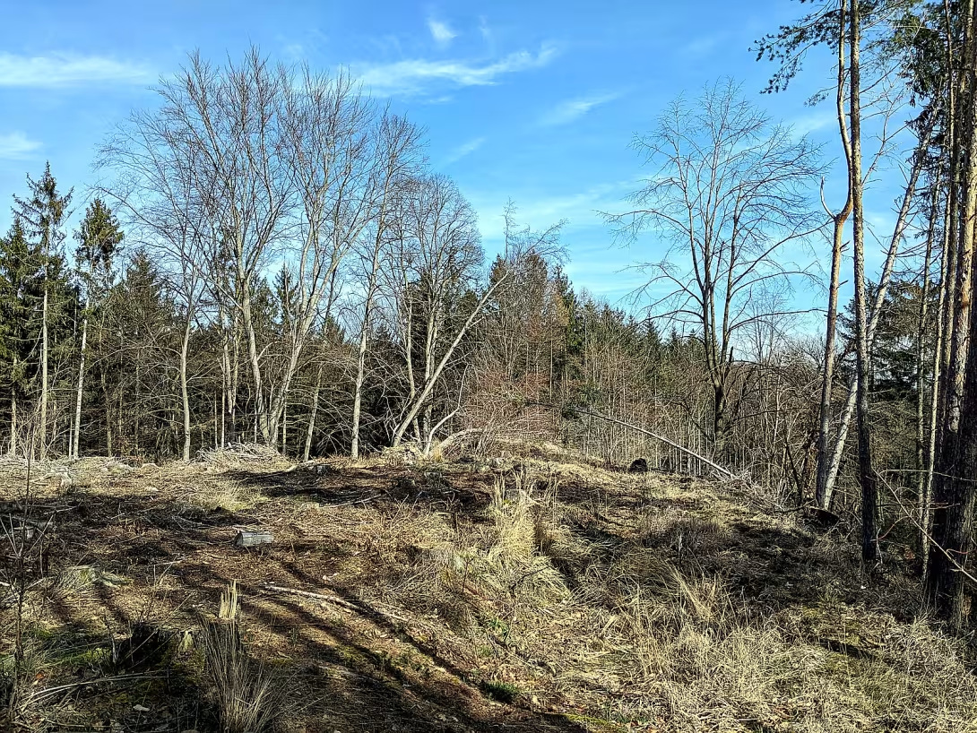
The island is a historical monument three kilometres southwest of the village Jedomělice in Kladno district. It is a extinct housing complex consisting of a fortress and a village, which were registered as cultural monuments in 1967. The fortress is situated on the island above the confluence of two small streams, which gave it strategic importance in the Middle Ages. On the southern edge of the settlement there is a natural monument Island near Jedomělic.
The first written mention of the Island dates back to 1395, but the forts and villages were probably created at the beginning of the 14th century. At the turn of the 14th and 15th centuries, there was a speedster Jakub ze Slaného and then his wife Anna. After her death, the property was transferred to the possession of the king, who donated it around 1413 to subchamber Hajk from Hodetín. The last mention of the village is from 1435, when it was already considered desolate.
The architecture of the fortress is characterised by a round plan of about 20 metres in diameter. The perimeter wall, forming a defensive ring, was 55 meters long. Inside probably stood a tower with a square plan; Her lower floor was stone and the upper part probably grafted. The fortress was protected by a western moat and a trapezoid farm yard surrounded by a low sputum wall. The only remnant of the court is the relic of the building at the expected entry point, which could serve as a hoarder or have a defensive function.
The villages consisted of five settlements on parks 14-27 metres wide. Four of them were on the north side of the village, one on the south side with L-shaped buildings. The other settlements were of an ordinary type with a passageway yard or had a courtyard built on three sides. The remnants of the walls are 60-70 cm wide, indicating their stone structure. On the west edge of the village there was a construction of a vague purpose.
Today, the island is accessible only on the field and forest roads from Jedomělice or Mšeka, because there is no marked tourist route on the site. Despite the desolate state, the monument is an interesting destination for historians and history lovers. The natural monument Ostrov u Jedomělec gives the place another dimension, making the visit to the site worth it.
The island is reminiscent of the era of the High Middle Ages and testifies to frequent changes in ownership during the political revolutions of the 15th century. Visiting this monument allows you to explore a quiet place that bears traces of the past and offers a view of the lives of people in this area more than half a thousand years ago.
Historical milestones
- 1395
- First written mention of the Island
- 1413
- The property belonged to subventricular Hajka from Hodetín
- 1435
- Last written mention of the village
Architectural development
The fortress had a round floor plan with a diameter of 20 metres with a perimeter wall of 55 metres. Inside was probably a tower with a stony bottom floor and grafted upper floors. The village estates had strong stone masonry 60 to 70 cm wide.
Historical events
1395: First written mention of the Island. 1413: The property fell to the subchamber of the Son of Hodetín. 1435: Last written mention of the village.
Owners
Jakub ze Slaného (turn of the 14th and 15th centuries), Anna (wife of James), King (after Anna's death), Hajek z Hodětína (around 1413).
Points of interest
- The fortress is situated on the island above the confluence of two small streams, which gave him strategic importance in the Middle Ages. - The fort had a round plan of about 20 metres in diameter and a perimeter wall of 55 metres in length. - The villages consisted of five settlements and in 1435 it was already considered desolate. - The fort was protected by a western moat and a trapezoid farm yard surrounded by a low sputum wall. - There is no marked tourist route on the site, it is accessible only by field and forest roads.
Guide
Show guide text
This text was created by artificial intelligence and has not been editorially reviewed. It may contain inaccuracies.
Welcome to the place where time has stopped and where nature is quietly placed over traces of ancient human activity. You are standing right on the edge of space, which, today, the eye of a common traveler may no longer be captured at first sight, but which was once the heart of this landscape. Look around you. Feel this gentle breeze and listen to the splendour of water. What you're seeing in front of you right now is a high-rise, sharp, corner of a country that was once home to the entire community. Even though grass and trees dominate here today, there is a story beneath your steps that goes deep into the Middle Ages.
Let's move forward in time together. To understand why this place was chosen, we need to look down where two small streams meet. It is this place, this strategic connection of watercourses, that has given sharpness to its importance. At a time when boundaries were measured by force and protection was the basis of survival, this position was absolutely ideal. The Castle Island was built at the beginning of the fourteenth century, probably to oversee the surroundings and check the paths along the watercourses. The first paper trail that allows us to name this place and connect it to history appears only in the year thirteen-ninety-five. Since then, there have been events that have shaped the fate of people living in this circle.
Now pay attention to how this place was organized. Even if you're standing in a space that is basically desolate today, try to draw in your imagination the shapes that once dominated here. This whole area wasn't just a random cluster of houses. He had a clear, almost geometric order that had to be very important to the people at the time. Imagine a round plan with a diameter of approximately 20 meters. The entire area was closed by a perimeter wall of fifty-five meters. This wall did not only provide protection, but also created a clear line between the village's safe inner world and the unknown external space. Within this circuit probably stood a tower which oversaw the surroundings and served as a symbol of strength and control.
Note that this fort was not a lonely fortified point. She was part of a living estate. The village consisted of five estates that were built of stone. Imagine these houses, their solid walls and the everyday life that took place in them. Stone buildings were a sign of stability and a certain property back then. This whole structure, the fortress and the village, formed one complex organism, where the military and civil headquarters were joined.
Looking at this landscape, you can ask yourself who were the people who once sought safety and home here. History will tell us several names that appear in documents as evidence that Island was a place of significance. In the year forty hundred and thirteen, the property of this place fell to subchamber Hayk of Hodetín. This tells us that Island was not just a village, but a place connected to powerful figures and authorities. Other names like Jakub ze Slaného or Anna appear in history. Who were these people? Was it the owners who decided here the fate of their subjects, or perhaps the family who sought peace in these stronger walls? Although their personal stories remain foggy, their presence here gives this place a human dimension.
And it is here that comes the greatest mystery that should impress you when you look at this desert island. How did it happen that a place that was so well built, so strategically placed and so firmly organized, just disappeared? How did it happen that a village that was prosperous at the beginning of the fourteenth century was already considered desolate in the 1940s? This is a question that historians are still looking for answers to. What happened between these milestones? Was it the wars that came with new waves of unrest or the perhaps disease that exhausted human power? Or did business trips just change and people went where there was more hope for prosperity?
We know that at the beginning of the seventeenth century, this whole thing was already completely abandoned. What you see now is just a silent echo of something that once was full of life, voices and work. This desolation that you now perceive is not just the absence of buildings, it is the presence of history that tries to speak through silence.
Don't be fooled by the fact that you won't find tall walls or roofs here today. Underneath your steps is still the basic geometry of this place. Continue to walk along the edge of this sharp, perceive the atmosphere of this place and try to find traces of that ancient, round village in the landscape. Take a look at the surrounding terrain and try to imagine what it looked like from where the tower was probably standing, to the confluence of the streams below you. Thank you for choosing to visit this history and for paying attention to these forgotten places. We wish you a pleasant journey.
Tips for visitors
The best time to visit is spring or autumn, when less dense vegetation better reveals the structure of the extinct settlement and surrounding landscape. To the memory we recommend to travel by car and park in the vicinity of the village Jedomělice or Mšeka, from where they lead the field and forest roads; We recommend that the current connection be checked by public transport in the Internet search engine.
Don't forget to wear solid shoes suitable for the field, enough drinking water and a map of the area so that you don't miss the exact point of the fort on the sharpness. For the best photo images we recommend using the light shortly before sunset, which will best highlight the relief above the confluence of streams and surrounding nature.
In the immediate surroundings, you can visit the Natural Monument Island near Jedomělic, which complements the historical experience of the beauty of local fauna and flora.
We recommend to families with children a game to discover the circular soil of the former village and a common walk along the forest roads, which is safe and offers space for exploring history in the field.
Frequently asked questions
Can the monument be visited?
This is a ruin. Such sites are often freely accessible, but some can only be visited with a guide or are closed for safety reasons. We have not verified the current situation – take care and respect any restrictions.
Where is the monument?
Location: Středočeský kraj. The map on this page shows the exact spot.
Why is the monument protected?
It is listed in the Central List of Cultural Monuments of the Czech Republic as a cultural monument (register no. 2000005714_0001). It is protected as part of a larger listed ensemble.
Businesses nearby
Do you run a restaurant, accommodation, shop, museum, rental, wellness or other visitor service near this monument? Show yourself directly to the people heading to it — this is how they will see you in the app and on the web:
Nearby
Natural monument Island near Jedomelice, field and forest roads from Jedomelice or Mšeka.
Accommodation nearby
Themed route
Thematic cruise route: Ostrov (tvrz) and surroundings
1.Ostrov (tvrz) * Type: * Historical landmark * Why is it worth a visit: * This fortress is a fascinating example of historical architecture that offers a view of life in the past. It is an ideal place for those who like history and want to learn more about the region.
2. Natural monument Island near Jedomělec * Type: * Natural reservation * Why is it worth a visit: * This area is an ideal place to relax in nature and observe different species of plants and animals. It's a beautiful place to have a picnic or explore on the sidewalk.
3. Field paths from Jedomělec * Type: * Walkways in rural landscape * Why is it worth a visit: * These paths offer the opportunity to explore the landscape beauty surrounding the fortress. They are ideal for walking or cycling and provide a view of rural life.
4. Forest roads from Mšeka * Type: * Forest trails * Why is it worth a visit: * These forest trails are a great place for quiet walks and disconnect. They are suitable for nature lovers who seek peaceful walking between trees.
This route offers a combination of historical and natural experiences and is ideal for a day trip.
Seasonal recommendations
Spring brings freshness and awakening life around the island's fortress. Fine sunlight and fresh greenery surrounding the ruins create an optimistic and peaceful atmosphere. The best time for visitors is in the morning, when nature is the most active. We recommend choosing layered clothing because the morning temperatures can still be low, while the afternoon can be pleasantly warm. In this period, people's movement is mild, allowing them to perceive history in peace.
In the summer season the monument is covered in full bloom and intense sun. High temperatures and sharp shadows can make the tour difficult, so it is best to arrive immediately after opening to avoid the greatest heat and the largest crowds. The atmosphere is alive and full of energy. It is necessary to have plenty of fluids, headgear and solid shoes with them, which can handle dry but uneven terrain between debris.
Autumn changes the surroundings of the fortress in a melancholy landscape full of shades of gold and brown. The morning fog and the low sun create dramatic lights that highlight the shadows in the cracks of an old stone. It's the perfect time for lovers of peace and photography. Due to the damp air and falling leaves we recommend to wear a waterproof jacket and shoes with good grip to keep the visit safe even in slippery places.
Zimą is a ruin of the machine and majestic. The absence of leaves reveals the whole shapes of historical structures and frost can create fascinating patterns on the stones. The atmosphere is quiet, lonely and very deep. Due to the short daylight, plan to visit in the brightest hours of the afternoon. It is necessary to dress thoroughly in warmer layers and prepare for possible snow or ice, which may make it difficult to access the monument.
Visualizations and artistic views


The visualisations are generated by artificial intelligence and serve as inspiration.
Photos from the area
Real photos taken near the monument

Zdroj a licence jsou uvedeny u každého snímku.
Tips from visitors
No tips yet. Be the first!
Log in and add your tip.
Sources and literature
Photos: MartinVeselka / CC BY-SA 4.0 — Wikimedia Commons. The author and licence also appear when you hover over the image.
Faktickým podkladem tohoto textu byl článek na Wikipedii, jehož autory jsou přispěvatelé Wikipedie. Článek je dostupný pod licencí CC BY-SA 4.0.
Location on the map
Příběhy a pověsti
Legendy, pověsti a příběhy spjaté s touto památkou

Fotografie návštěvníků
Zatím žádné fotografie. Buďte první, kdo přidá fotografii z návštěvy!
Log in a přidejte svou fotografii nebo hodnoťte.
Za ověřenou návštěvu v aplikaci získáte víc bodů — poznáme podle GPS, že jste na místě.
Reviews and comments