





Přerovská hůra Hillfort
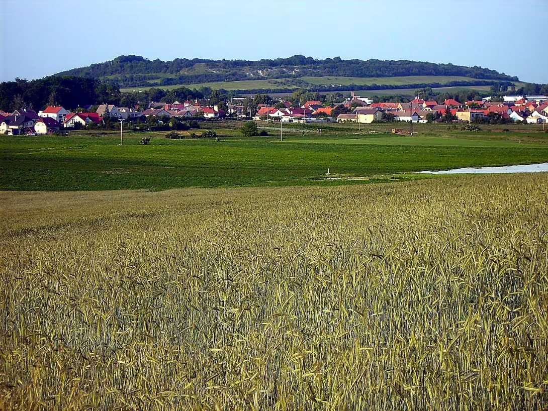
Přerovská hůra u Přerov nad Labem in the district Nymburk is an important primordial and early medieval castle. It is situated on the top of the same-name hill in the Central Bohemia region. This monument is made up of a plateau of more than 19 hectares, the slopes of which exceed the surrounding terrain by up to 50 metres. The site represents evidence of multi-phase settlement from bronze to early Middle Ages.
The favourable position attracted the inhabitants in the prehistoric world. During the period of the Lužický, Knovíska and Silesian culture during the Bronze period there was an unfortified settlement. The formation of the fortification system itself is not exactly dated. It is assumed, however, that the fort on the hill existed in the late period of the Halštatians and then again in the period of the castle in the early Middle Ages. Whether both supported fortifications worked simultaneously remains unclear.
The construction form of the castle fully benefited from the natural terrain. With the exception of the east side, the platform was protected by steep slopes at a height of 237 metres above sea level. On the easiest accessible east side a fortification system consisting of a pair of wallets and an intermediate moat was created in the narrowest place. According to the preserved descriptions, the two opposite sides were connected about 100 metres long. In the western part of the platform, approximately 3 hectares of space defined the inner cross fortification. According to geophysical measurements, it was composed of two shallow parallel ditches and a wall with traces of dead materials in the body.
Important information about the site was left by archaeologist Josef Ladislav Píč in the 1880s, who was still on the site watching the remains of the wood with fragments of masonry. However, this archaeological site has suffered considerable damage from long-term agricultural activities. The bays and ditches were gradually broken and the plowing damage continued at the beginning of the twenty-first century.
In 2009, Přerovská hůra was declared a protected cultural monument. At present, the remains of historical fortifications are already visible as field waves, with detailed structures revealing mainly aerial images and geophysical measurements. Přerovská hůra represents valuable evidence of prehistoric construction and long-term human presence in the region of Poland. Visiting this design offers an opportunity to explore the terrain remains of the ancient castle and to understand the defensive strategy of our ancestors in the landscape.
Historical milestones
- around 1300 BC l.
- The creation of an unfortified settlement during the period of the Lužice culture.
- around 500 BC l.
- The expected formation of the first fortified fort.
- around 900
- Restoring and exploiting the fort in the early Middle Ages.
- 1880-1889
- An archaeological survey and a description of the remnants of Joseph Ladislav Dick.
- 2009
- Declaration of the site as a protected cultural monument of the Czech Republic.
Architectural development
The fortification consisted of a pair of valleys and a ditch on the east side and an internal transverse system in the west. There are traces of dead material in the wavy body. Today, the remains of the buildings are only visible as curly terrain.
Historical events
2009: The site was declared a protected cultural monument.
Points of interest
- The upper plateau of the castle is over 19 hectares and its slopes exceed the surrounding terrain by up to 50 metres. - There are traces of dead material in the wall of the inner fortification, which revealed geophysical measurements. - The archaeologist Josef Ladislav Píč in the nineteenth century on the spot observed the remnants of wool with fragments of masonry. - The remains of the fortifications have been badly damaged and damaged over time by long-term agricultural activities. - Today the details of the structures of the castle are visible mainly thanks to aerial images and results of geophysical measurements.
Guide
Show guide text
This text was created by artificial intelligence and has not been editorially reviewed. It may contain inaccuracies.
Welcome to this special place. You are standing in front of the Přerovská hora, an important prehistoric and early medieval castle, which stands at the top of the same name. If you look around and look at the surrounding landscape, you might think it's a peaceful natural corner of Polabi. But beneath your feet and all around you is a landscape with an extremely rich and deep history. The plateau on which you are now located has a respectable area over 19 hectares, and the steep slopes of this hill exceed the surrounding lowland terrain by up to 50 metres. It is this natural high that has lured people into settlement in the deep past, providing a great overview of the surroundings and natural protection.
Let's move forward in time and see how this place was formed. The first people here began to leave their tracks about 300 BC. At that time there was a fortified settlement of members of the Lužice culture. People lived here, managed fertile land in the vicinity, and gradually enjoyed this place for its strategic location. Centuries have passed, and around five hundred BC, the character of the place has changed fundamentally. The first anticipated fortified fort was created here. The people understood at that time that space needed to be protected, so they began to build the first mounds and defensive moats. This step included Přerovská hůra among the major power and social centers of the time. But development did not stop with the advent of the early Middle Ages. Around the year nine hundred AD the castle was restored and intensively used. The people of the time followed the work of their ancestors and breathed new life into the old place, as evidenced by numerous archaeological findings from this period.
Now pay attention to what lies ahead and engage your imagination. The historical fortifications, which once formed massive walls and deep trenches protecting the inhabitants of the castle, were, unfortunately, gradually torn up over the centuries by an agricultural ornament. Today you will not find standing stone walls or preserved gates. Instead, traces of former fortifications are seen primarily as fine terrain ripples in the landscape, which, at the right angle of light, can be observed along the entire plateau. When you look carefully at the terrain in front of you, notice these subtle terrain inequalities. They are the silent witnesses of human labor thousands of years ago.
With this place there are also fascinating stories and personalities that dedicated their lives to his examination. The most important figures are undoubtedly archaeologist Josef Ladislav Píč. It was he who carried out a systematic archaeological survey on this site between eighteen hundred and eighty and eighteen hundred and ninety-nine. He described with great interest the remnants of the local wavy and tried to decipher the secrets that Přerovská hůra had hidden from humans for centuries. Thanks to his careful work, the then professional public learned of the great importance of this place, and his findings helped to include the Přerovská up on the map of European archaeology.
Let's now reveal one of the interesting things that shows that this place still holds unsuspecting secrets. Even though the surface of the soil is peaceful, modern scientific methods can look underground without the need to dig. Geophysical measurements on the site have produced very interesting results. In the building of the inner fortifications there are traces of bulkhead materials. This detection suggests that the fort has faced devastating fires in the past that have left traces in the very structure of the defensive valleys. We can only speculate whether it was an enemy raid, an unfortunate accident, or a ritual renewal of the site.
The importance of this unique space was rightly appreciated even in modern times. In the year two thousand and nine, the whole site was officially declared a protected cultural monument of the Czech Republic, thus ensuring its protection for future generations. We hope you enjoyed walking in the footsteps of our ancestors. Take some time to observe the surrounding landscape from this height, perceive the atmosphere of the place where history was written, and when you are ready, you can continue to explore the surroundings of Přerov nad Labem. Thank you for listening to our audio guide, and we wish you a wonderful rest of the day.
Tips for visitors
Best time to visit The Přerovská mountains is early in the morning or before sunset, when the sun's light beautifully illustrates the atmosphere of this historic place and provides ideal conditions for observing the landscape from the elevated peak. You can use a passenger car or public transport for transport, and we recommend checking the specific and current connection to Přerov nad Labem in a common connection search engine. At the top of the hill with a height of up to 50 metres above the surrounding terrain, remember to take firm hiking shoes suitable for the terrain, enough drinking water and snacks, because you will not find refreshments at the archaeological site itself. The best places for photography are the edges of the former castle, where the views to Polabi are opened, with the softest light for the pictures being obtained during the golden watch. In the immediate vicinity of Přerovská hříra, the very top of the hill is waiting for you, with an elevation of up to 50 metres above the surrounding terrain, which attracts you to a peaceful walk through nature connected with the discovery of the history of prehistoric and early medieval settlement.
Businesses nearby
Do you run a restaurant, accommodation, shop, museum, rental, wellness or other visitor service near this monument? Show yourself directly to the people heading to it — this is how they will see you in the app and on the web:
Nearby
Top of the hill with an elevation of up to 50 meters above the surrounding terrain.
Accommodation nearby
Themed route
1.Přerovská hůra Type: Archaeological site Why is it worth a visit: The top of the hill with an elevation of up to 50 metres above the surrounding terrain offers interesting archaeological tracks and views to the region.
Přerovská hůra Type: Top Why it is worth a visit: The very top of the hill with an elevation of up to 50 metres above the surrounding terrain is the ideal place to discover the location in the village Přerov nad Labem.
3. Přerovská hůra Type: Natural high Why is it worth a visit: The height profile with an elevation of up to 50 metres above the surrounding terrain creates a dominant area worth exploring.
Seasonal recommendations
Spring on Přerovská worse brings a gradual awakening of nature, where the vast sides and sets around Přerov nad Labem are wrapped in fresh green tones and flowering fruit trees. In the morning, the low sun creates fine foggy hams above the Polash lowlands, which gives archeological sites a mystical nature. In this period you will meet only a few tourists, so you will enjoy the quiet atmosphere fully. Due to the frequent spring showers and the variable wind on the open top, a waterproof jacket and solid, ideally waterproof shoes are useful because the field roads are muddy after the rain. The best time to visit is in the morning, when the sun is warm and not burning.
The summer is much worse dominated by lush vegetation, which, on the other hand, has some growth in terrain inequality, which gives the place a romantic wild touch. The sunlight is very intense during the day and due to the absence of shadow on top we recommend arriving either early in the morning or late in the afternoon when light breaks into golden shades and the landscape is the most photogenic. Although the main tourist onslaught is more likely to go to a nearby museum in the village, in the main summer season you will meet occasional hikers and cyclists on the hill. The basic equipment should be headgear, sunglasses, plenty of drinking water and a light, airy clothing layer protecting from insects and sun.
Autumn turns the Přerovská Usov into a colorful palette, where the surrounding trees and bushes play shades of yellow, orange and red. The lighting is very dramatic throughout the day thanks to the morning fog and low sun, which will be especially appreciated by lovers of landscape photography. The atmosphere is melancholy and calm, ideal for deep exploration of history and contemplation in nature. The practical pitfalls are the cold wind flowing from the Polash plain, so do not underestimate the layered clothing, hat and gloves. The best time for a walk is noon and early afternoon, when the temperature reaches its daily maximum before it begins to cool quickly.
Winter gives this archaeological place a raw and quiet face, especially when the landscape is covered with snow and the trees are covered with frost. The lighting is very short, but the winter sun is low above the horizon magic on the snowy plains of long shadows and unique atmosphere. Since the days are the shortest in a year, it is necessary to plan a visit to the morning or early afternoon hours in order to descend in daylight. For climbing on a icy and slippery slope are the absolute necessity of high-quality winter hills, warm waterproof clothes and hot drink in the thermos, which will heat up reliably on the wind peak.
Visualizations and artistic views


The visualisations are generated by artificial intelligence and serve as inspiration.
Photos from the area
Real photos taken near the monument


Zdroj a licence jsou uvedeny u každého snímku.
Tips from visitors
No tips yet. Be the first!
Log in and add your tip.
Sources and literature
Photos: Petr Vilgus / CC BY 2.5 — Wikimedia Commons. The author and licence also appear when you hover over the image.
Faktickým podkladem tohoto textu byl článek na Wikipedii, jehož autory jsou přispěvatelé Wikipedie. Článek je dostupný pod licencí CC BY-SA 4.0.
Location on the map
Příběhy a pověsti
Legendy, pověsti a příběhy spjaté s touto památkou

Fotografie návštěvníků
Zatím žádné fotografie. Buďte první, kdo přidá fotografii z návštěvy!
Log in a přidejte svou fotografii nebo hodnoťte.
Za ověřenou návštěvu v aplikaci získáte víc bodů — poznáme podle GPS, že jste na místě.
Reviews and comments