



Šance Archaeological site
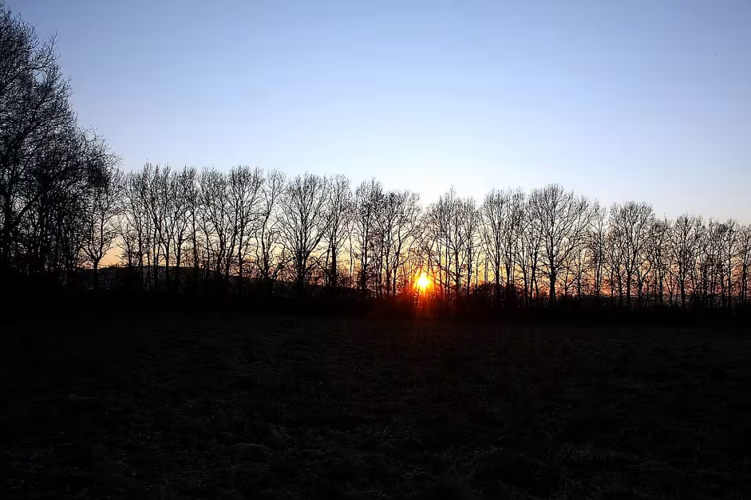
The Šance locality, also known as the Swedish Chance, represents the best preserved example of a quadrilateral valley border of type Viereckschanze in the Czech Republic. This archaeological site is located in the cadastral territory of the village Skřipel and is probably from the Latin era. The area is protected as a cultural monument and offers a unique view of fortified structures from the end of the prehistory.
The creation of the building is put into the Latin era, i.e. the period when Central Europe was under the influence of Celtic culture. This era was characterised by the development of the hardware industry and organized mining. Although no ancient artifacts have yet been found on the premises, its classification is based on a typological match with similar European objects. Also important are the findings in the nearby area, such as gold coin depot near the neighbouring Osov. Experts assume that the fence served as the seat of the local social elite, which controlled the deposits of raw materials, especially gold. Older scientific literature interpreted these objects as places of cultural character.
The building design of the site has a rectangular plan of 125 to 105 metres. The whole area is surrounded by massive walls that reach a width of ten to twelve meters and a height of up to three meters. On the outside, the moat is supplemented by 11 metres wide and 3 metres deep. It's lined up most of the perimeter except for part of the north side. In these places another cross-wall was recorded in the past, but the owner of the land had it distributed at the end of the nineteenth century.
The original entrance to the compound was most likely located in the middle of the west side. Current entrances in the northwest and southeast corners are not original. It was not until the late nineteenth century for economic purposes that they were penetrated. A significant element inside the complex is a heavily watered round space approximately two metres in diameter, situated near the southeast tip. Specific humid vegetation here suggests the existence of a extinct well. While the wells are a common part of similar buildings in today's Germany, it is an extraordinary phenomenon within Czech findings.
The first expert archaeological research of the site was carried out in 1878 by Břetislav Jelínek. His work documented the status of the monument at a time when it had not yet been disturbed by later landscaping. It's because of his records that we know of the existence of the northern wall. Although the inner area of the building remains poor in terms of movable findings, the overall preservation of the waves and ditches makes Skríple a key location for late iron studies.
The visit to Šance offers an authentic experience of contact with monumental primordial architecture, which has kept its visible form in the landscape even after thousands of years. For a curious tourist, this place represents an opportunity to learn about the Celtic elite's power centers and understand how our ancestors controlled and protected strategic territories.
Historical milestones
- about 150 bc
- The formation of a fortified site in late Latin time.
- about 100 bc
- The flowering of Celtic manor and the control of gold mining in the vicinity.
- 1878
- First expert archaeological research under the leadership of Břetislav Jelínek.
- end of the 19th century
- Removing part of the waves and breaking through new entrances by the owner.
Architectural development
The location has a rectangular plan of 125 × 105 metres. It is surrounded by walls 10 to 12 metres wide and a deep moat 11 metres wide. The original entrance to the premises was probably located in the middle of the west side.
Points of interest
- This is the best preserved example of a quadrilateral wall of its kind in the Czech Republic. It is probably from the Latin era when Central Europe was under the influence of Celtic culture. - Experts assume that the site served as the seat of the social elite, which controlled the deposits of raw materials, especially gold. Older scientific literature interpreted these objects as places intended for religious purposes. - No primordial objects have yet been found on the premises, but a treasure of gold coins has been discovered in the vicinity. The classification of the monument is based on compliance with similar European buildings. - Inside is a soggy place that suggests a fallen well. While the wells of these buildings are common in neighbouring Germany, it is an exceptional phenomenon within the Czech find. - The current entrances to the premises are not original and were not penetrated until the end of the nineteenth century for economic purposes. The original entrance was probably in the middle of the west side.
Guide
Show guide text
This text was created by artificial intelligence and has not been editorially reviewed. It may contain inaccuracies.
Welcome to the village Skřipel. Stop for a moment, take a breath and feel the space around you. You are standing right in front of a place that at first glance may look like an inconspicuous part of the landscape, but in fact you are in the presence of one of the most important archaeological monuments in our entire region. Look in front of you and feel the terrain line. What you see are the remnants of an ancient fortified compound that forms a regular quadrilateral wall. It may seem like a slight ripple of the earth to you, but for historians and archaeologists, this place is a unique place. It is the best preserved monument of its kind in the Czech Republic.
Let us now move together in time much further back, to a time when this landscape looked completely different. Imagine it's approximately 150 BC. We're late, which experts call Latin. At that time, Central Europe was under the strong influence of Celtic culture. The Celts were masters of forging, merchants and builders who were able to organize complex social structures. It was during this period that this area was created. But it was not an ordinary village or a simple fortification to protect against enemies. The entire space was carefully planned into the shape of a regular quadrilateral, suggesting deep knowledge of geometry and architecture at the time.
Have you now noticed how the walls are deployed? Notice this regular arrangement. The whole space was surrounded by walls at the time of its creation that separated the inner space from the outside world. This type of construction had a very specific purpose. Historians assume that this place was not used for ordinary housing for a wide range of residents, but it was the seat of the local social elite. So imagine here people with high status, influential personalities who ruled the surrounding territory and decided on the fate of local communities.
But why was this elite here, in the village of Skřipel? The answer lies in the very country you're walking on. This area was rich in mineral resources in the giveaway. And specifically, it was the most precious of metals, gold. Control over gold deposits and mining was the main reason why this fortification was created here. Around the year 100 BC, this Celtic mansion experienced its greatest boom. Imagine entering this compound at the time. You'd feel tension, power, and wealth. Here it was probably decided how much gold would be extracted, where it would be exported and what it would be exchanged for in the vast trade routes that linked Central Europe to the far corners of the world back then.
Now pay attention to how this monument was handled in much newer times. The history of this place is not only about the Celts, but also about the people who took care of it or influenced it in the last centuries. Let's move forward in time to the year one thousand eight hundred seventy-eight. It was this year that Břetislav Jelínek started working here. He was a respected expert who was the first to carry out systematic archaeological research on this site. Thanks to his work and his diligence, we are able to understand what we are in front of us today. At that time, Jelinek revealed the true value of this quadrilateral fence and helped to make history a key point for understanding Celtic presence in our countries.
Unfortunately, however, the history of this place knows even sadder chapters. If you look carefully at today's shape of the waves, you may notice that they are not completely intact. At the end of the nineteenth century, something happened that we now consider tragic. The owner of the land at that time decided to remove part of the wares and break through new entrances in them to make it easier to manage the land. At that time, it was not fully understood what an irreplaceable value these grave and vale structures have. Despite these interventions, however, enough information and matter remained to be said today with certainty that it is the country's most important representative.
Stop for a moment and think about one mystery. Even though we know that the elite lived here and that it was gold, there are still many questions that remain unanswered. What exactly did the buildings inside this quadrilateral look like? Were they wooden halls or maybe more complex buildings? What was the exact ritual that could be connected to these times? The Celts often associated their buildings with the spiritual world. It is possible that this fence was not only to protect property and raw materials, but also to have a symbolic significance, which separated the sacred space of the ruler from the ordinary world of other people. These secrets are still hidden in the ground beneath your feet, waiting for generations to come.
Feel the atmosphere of this place now. It is fascinating to think that in this quiet corner of the village Skřipel there were stories of power, wealth and hard work in the mines. This entire space is now protected as a cultural monument so that future generations can feel the connection to the ancient past, just like you do today. It's a silent testimony about people who lived here two thousand years ago, who had their dreams, their ambitions and their craft, and who left this trail behind in the landscape.
Thank you for accompanying me on this short journey through time. Now I invite you to walk quietly around the area, walk around its borders, and try to imagine in your mind what this place looked like at the time of its greatest bloom. Follow the lines of the earth and think about how many layers of history lie beneath the surface you walk on. I wish you a pleasant rest of the visit in the village Skřipel and hope that these encounters with the Celtic past inspired you to further discover our historical treasures. Goodbye.
Tips for visitors
The best time to visit is early spring or autumn, when grass is low and the surrounding trees are not fully foliage. This will help you see the terrain inequalities and the very walls that make up this Celtic fence. In summer, the site may be overgrown by high vegetation, making it difficult to recognize historical structures in the landscape.
You can easily reach the village Skřipel by car, which can be left in a suitable location in the village. From there, it leads to the location of the field road. If you use public transport, look for a connection to a stop in the village and count on a short walk. You should check the exact times of departure and arrivals in the current timetables on the network.
For the tour we recommend fixed shoes because you will move in unpaved terrain and in meadows. The ideal time for photography is shortly after sunrise or before sunset, when low light creates long shadows and highlights the plasticity of the waves. If you own a shooting device from a height, you will get the best view of the regular square plan of the entire area.
For families with children, a visit is a great opportunity to move in the fresh air and to interpret ancient history. Since there are no other specific sights in the immediate vicinity, you can fully focus on the quiet atmosphere of this place and have a little family rest in nature. Don't forget to take enough fluids and insect protection.
Frequently asked questions
Can the monument be visited?
This is an archaeological site. Often there is little to see on the ground and the land may be private. We have not verified access.
Where is the monument?
Location: Skřipel, Středočeský kraj. The map on this page shows the exact spot.
Why is the monument protected?
It is listed in the Central List of Cultural Monuments of the Czech Republic as a cultural monument (register no. 1000146661).
Businesses nearby
Do you run a restaurant, accommodation, shop, museum, rental, wellness or other visitor service near this monument? Show yourself directly to the people heading to it — this is how they will see you in the app and on the web:
Events nearby



Zdroj akcí: otevřená data měst a obcí ČR (Národní katalog otevřených dat) a kalendář akcí Národního památkového ústavu.
Nearby
🏰 Historic sites (145)
- Šance 0.0 km
- Osov 1.1 km
- sv. Donát z Münstereifelu 1.3 km
- sv. Jan Nepomucký 1.3 km
- Mariánský sloup 2.5 km
- Památník 2.9 km
- Šemíkův pomník 3.4 km
- Pomník Kristiána Gassauera 3.6 km
- Roman Rudník 4.3 km
- Galerie a muzeum M.D. Rettigové 4.7 km +420 725 978 876 web
- Památník padlým 5.3 km
- U Fabiána 6.0 km
- Viklan 6.6 km
- Václav IV. 6.7 km
- Partyzánský pomník 6.8 km
- Klonk u Suchomast 6.9 km
- Malá vyhlídka - infopanel č.8 7.0 km
- Vyšebohy 7.5 km
- Hradiště 7.9 km
- Jaroslav Petrbok 8.5 km
🍽️ Restaurants and dining (282)
- U Kozohorských 1.3 km
- Hasičárna Na Žižkově 2.0 km +420 733 163 991
- U Frajerů 2.5 km Tyršovo náměstí 60 +420 311 584 115
- Kafárna 2.5 km +420 771 166 032
- Záložna 2.6 km Tyršovo náměstí 221
- Pivovar Hostomice pod Brdy 2.7 km Pivovarská 214 +420 737 499 468;+420 603 712 953 web
- Europajzl U Pajmy 3.1 km +420 602 738 343
- Penzion Somnium 3.9 km +420 734 666 858 web
- Hostinec U Paní Magdalény 4.8 km +420 606 944 074 web
- Na Růžku 4.8 km
- Hostinec U Márinky 5.2 km
- U Prejzků 5.6 km Dolní 2 +420 602 320 933 web
- U Hejduků 5.7 km Hořejší
- Pivovarská restaurace Suchomasty 6.5 km +420 774 121 331 web
- CANTINA - Sole in forno 6.9 km +420 734146008
- U Litavky 6.9 km +420720285510 web
- Hospůdka U Duba 7.0 km
- U Menclů 8.0 km
- Krmelec Vlaška 8.2 km Na Vlašce 2065 +420 721 588 815 web
- U Boušků 8.2 km Dlážděná 20
🏨 Accommodation (55)
- Seník u pramene Brdlavky 4.4 km
- New Michilimackinac 7.1 km
- Zlaté dno 7.2 km
- Casablanca 7.3 km
- Lesná 8.0 km
- Vrahův kemp 8.1 km
- Na Mechu 8.2 km
- Bílá skála 8.2 km
- Carcaio 8.4 km
- Malý Janek 8.7 km Eškova 33 +420 731 142 999 web
- Restaurace a Penzion EŠKA 8.7 km +420 318 692 805 web
- Swamp 8.9 km
- Ermi 9.0 km
- Restaurace & Penzion Rochota 9.1 km Rochoty 930 +420721518394 web
- Penzion Rochota - depandance 9.1 km
- Starý smrk 9.2 km
- Na statku 9.5 km
- zámek Dobříš 9.7 km web
- Anamo 10.1 km
- Penzion a Pivovar Nový Rybník 10.9 km
🚲 Rentals and sport (33)
- Střelnice 7.5 km
- Cyklo Kraken 8.9 km Mládeže 447 +420 725 768 997 web
- TJ Sokol Jince 9.0 km web
- Bio Koupaliště 9.1 km
- Kola a lyže Beran 9.2 km Tyršovo náměstí 51 +420 602 439 937 web
- Tělocvičná jednota Sokol Dobříš 9.2 km
- tělocvičny 1. a 2. ZŠ 9.5 km
- Střelnice Litohlavy 10.5 km
- Koupaliště Města Zdice 11.0 km web
- Martes Sport 11.5 km Obchodní 542 +420 703 377 841
- TJ Sparta Podluhy 11.8 km
- COMI Sport 12.2 km Lesní 1144/2 +420 603 466 915 web
- Sportovní hala Hořovice 12.3 km Ke Stadionu 1385/1
- Sport Voříšek Jan 12.4 km
- Kola Bartoš 12.5 km 9. května 1317/21 +420 606 217 638 web
- VELO CAFÉ GARÁŽ 12.7 km Hradní +420724877571
- 45402 Králův Dvůr Sportovní hala 12.7 km
- Sportovní hala Králův Dvůr 12.7 km web
- Tělocvična ZŠ 12.8 km
- Sokolovna Tetín 12.8 km web
🥾 Hiking and nature (233)
- Šance u Skřipele 0.0 km
- Studánka U Písku 1.9 km
- Charvát 2.7 km
- Liška 3.1 km
- Jechova studánka 3.1 km
- Roudný 3.5 km
- Hradec 3.6 km
- Studený Vrch 3.6 km
- Studený vrch 3.6 km +420 606 436 893 web
- Brdo 4.1 km
- Brdlavka 4.2 km
- Stožec 4.4 km
- Housina 4.5 km
- Malá baba 4.7 km
- Jistevník 4.9 km
- Fabiánovo lože 5.0 km
- Velká baba 5.2 km
- studanka Nad Trnovou 5.3 km
- Kazatelna 5.5 km
- Helenčina studánka 5.5 km
Accommodation nearby
Themed route
1. Input information board - information point. Here you will get a basic overview of the history and importance of the site. 2. Earth walls - archaeological remains. Walk around the old fortifications will allow a better understanding of the area of the castle. 3. Interior of the castle - historical center. Exploring the inner part where the main activity was concentrated in the past. 4. View section - view. A place with the best overview of the whole building and surrounding landscape.
Seasonal recommendations
Spring in the archaeological site Šance at the village Skřipel brings awakening nature, when low undergrowth is not yet fully overgrown by lush greenery, which significantly facilitates the observation of the terrain waves and remnants of ancient settlements. The lighting is very clean and slightly dispersed by the spring sun, which creates fine shadows in the trenches. At this time, you will meet only a few visitors, so you will enjoy a deep calm. We recommend fixed waterproof shoes because the soil after the rain and rain is wet and slippery. The ideal time for visiting is in the morning, when the morning herpes slowly retreats.
Summer in Shanky offers a completely different atmosphere, determined by dense surrounding vegetation and tree crowns casting a deep shadow on ancient forests. Sun rays penetrate the leaves and create an interesting game of light and shadow on the ground. In the main summer season, lovers of summer trips come here sometimes, but the place still retains its hidden character. Due to afternoon temperature peaks, it is best to leave first thing in the morning or vice versa in the evening. Don't forget to wear your headgear, enough drinking water and ticks repellent, which are more than one in the warm months of grassy crops.
Autumn in this lark area is characterized by colorful leaves falling from trees, which covers the whole terrain with golden carpet and gives the place melancholic character. The low sun creates long shadows, and often morning fog soars above the landscape, underlining the mysterious mood of the old site. On colder autumn days, there's hardly anyone here. Wear a windbreaker to protect against cold wind and warmer layered clothing, because it can blow in the exposed area. The best time for the tour is around noon, when the temperature reaches its daily maximum and the fog usually dissolves.
Winter covers the Šance into deep calm and snow blankets, which perfectly draws the original walls and dirt terrain hidden underneath. The lighting is very short in this period, while the low sun radiates the landscape with a cool sharp light only a few hours a day. Visiting is minimal in winter months, often you will be all alone. For this season, very warm winter clothes, hats, gloves and tight shoes with anti-slip soles are essential in case of icy terrain. In light of the early twilight, plan your walk around noon to make the full tour in daylight.
Visualizations and artistic views


The visualisations are generated by artificial intelligence and serve as inspiration.
Photos from the area
Real photos taken near the monument

Zdroj a licence jsou uvedeny u každého snímku.
Tips from visitors
No tips yet. Be the first!
Log in and add your tip.
Sources and literature
Photos: Petr Snajdr / CC BY-SA 3.0 — Wikimedia Commons. The author and licence also appear when you hover over the image.
Faktickým podkladem tohoto textu byl článek na Wikipedii, jehož autory jsou přispěvatelé Wikipedie. Článek je dostupný pod licencí CC BY-SA 4.0.
Location on the map
Příběhy a pověsti
Legendy, pověsti a příběhy spjaté s touto památkou
Fotografie návštěvníků
Zatím žádné fotografie. Buďte první, kdo přidá fotografii z návštěvy!
Log in a přidejte svou fotografii nebo hodnoťte.
Za ověřenou návštěvu v aplikaci získáte víc bodů — poznáme podle GPS, že jste na místě.
Reviews and comments