



Vladař Hillfort
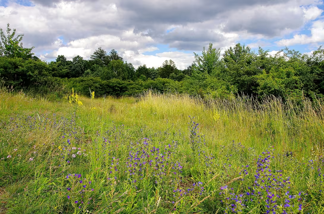
The castle Vladař in Karlovy Vary is one of the most important Celtic fortified conurbations in Bohemia. This table mountain rises to an altitude of 693 meters. It reached its greatest bloom in the 5th to 4th century BC and probably functioned as a power center, which was the opposite of the headquarters of the Envy. Since 1958, the site has been protected as a cultural monument.
Historical sources suggest that the castle was created as a strategic fortress during the Celtic settlement. The oldest history of the place was left with little direct news. However, archaeological findings show that the space was intensively utilised and almost completely deforested at the time of flowering. Around 200 BC, there was a violent break in development that accompanied a devastating fire. Subsequently, the settlement was thinned and at the turn of the year the place was abandoned completely, after which the landscape was desolate for a long time. A new wave of colonization took place in the 6th century AD.
The construction form of the castle included an extensive system of fortifications, which passed five stages of construction. The walls were 8 metres wide and their outside was held at a height of 4.2 metres. The construction was reinforced with wood, which was confirmed by the discovery of spurred stones testifying to the destruction of the walls by fire. There is an artificial water tank in the middle of the acropolis. Its sediments have provided scientists with a valuable record of the prehistoric evolution of vegetation. At the west foot of the mountain, a precise wooden structure of oak fries, dating back to the 8th to 4th century BC, was uncovered. It probably served as a system for capturing water from the spring.
The first written mention of the castle dates back to the 16th century from the chronicle Václav Hájek from Libočan. In the 19th century, the site was classified as a significant primordial castle, but for a long time it remained a party to the professional interest. In modern history, the memory has been damaged by agricultural activity, road building and illegal excavation of persons using metal detectors. Systematic archaeological research was launched only in 2002, when experts examined probes in damaged sites and wall profile.
Significant findings include fragments of ceramics, flint blade and bronze figure, which probably formed part of a tripod of the Etruscan type. In 2004, atypical primordial ceramics were found in the premises. Currently, the documentation of the site's status under the auspices of the Archaeological Institute in Prague and the Civic Association Vladař is ongoing. A digital field model has also been created for research purposes using laser imaging.
Vladař is a unique witness to the prehistoric settlement and technical maturity of the then society. Visiting this place offers the opportunity to become acquainted with the history of Celtic fortification in the authentic environment of the table mountain. However, when moving in the field, care must be taken to protect the archaeological layers and respect the status of this cultural monument.
Historical milestones
- 16th Century
- The first written mention of the castle in the chronicle Václav Hájek of Libočan.
- 1958
- The location was declared a cultural monument.
- 2002
- The launch of the first systematic archaeological research and rescue research.
Architectural development
The fort went through five stages of building a fortification, which was reinforced by wooden construction. The original walls were 8 metres wide and 4.2 metres high. Inside the acropolis there was an artificial water tank, which today serves as a valuable source for paleoenvironmental analysis.
Historical events
There was a violent interruption in the development of the castle accompanied by a devastating fire around 200 B.C. At the turn of the year, the castle was completely abandoned and the landscape was desolate for a long time.
Points of interest
- The barrier Vladař is a table mountain that rises to an altitude of 693 metres. - Around 200 BC, there was a violent interruption in the development of the castle, which accompanied a devastating fire. - The construction form of the castle included walls 8 metres wide, the outside of which was 4.2 metres high. - There is an artificial water tank in the middle of the acropolis whose sediment provided scientists with a record of the prehistoric evolution of vegetation. - Major findings include a bronze figure, which was probably part of a tripod of the Etruscan type.
Guide
Show guide text
This text was created by artificial intelligence and has not been editorially reviewed. It may contain inaccuracies.
Welcome here, to the top of one of the most significant dominance in this country. You're standing in front of Vladař, a place that keeps secrets for thousands of years. You've probably noticed that you're not on an ordinary hill, but on a fascinating table mountain that rises to an altitude of six hundred ninety-three meters. Feel the space around you, the open view and silence that rules this place today. In front of you is a space that was once a noisy, lively and powerful center of the entire region. Even if you see at first sight at first sight mainly nature and terrain formations, the history of one of the most important Celtic communities sleeps under your feet.
Let us now return together in time, deep into the past, namely the fifth and fourth century BC. It was at this time that the castle Vladař experienced its greatest bloom. The Celts, the people known for their skill in craft and trading, have chosen this very strategic position for their headquarters. Why here? The answer is in the form of a table mountain itself. Such a place provided natural protection and an incredible overview of the surroundings. Vladař was not just an ordinary village, but probably served as a power center. So imagine that you have just entered the administrative and spiritual heart of the entire region, where the fate of the people, where the trade took place and where the power of the local elite was concentrated.
Now pay attention to the terrain around you. Although time and human activity from Railsa have erased clear contours, you can still see the trail of brilliant Celtic engineering here. Notice the extensive system of fortifications surrounding this mansion. Try to reconstruct the walls that once stood here. It wasn't just a simple wall, it was a massive structure about eight meters wide. Imagine how much work, sweat, and the efforts of thousands of hands were needed to build walls in this terrain, whose outside side was more than four metres tall. These walls formed an impenetrable ring that protected the people from attacks from the outside while demonstrating the power and wealth of the ruler.
If you move further, focus on the acropolis area. Acropolis was the highest and most important point of the castle, a place where the most important buildings were probably located and where the highest layer of society was located. It's the heart of the complex. But it is important that you know that what you see today is just a shadow of former glory. Over the centuries, this site has been significantly damaged. The agricultural activity that has developed in the area and, unfortunately, illegal excavations from the past have destroyed some of the original structures. Yet even in these remains, the incredible atmosphere of the place that once dominated the surrounding landscape remains.
Who told you about this place before modern science? Let's stop at a historical personality. The first written mention of the castle Vladař appears only in the 16th century in a chronicle written by Václav Hájek z Libočan. Imagine how fascinating it must have been for the chronicler of that time to write down the existence of this mysterious place, which was already a long forgotten ruin at his time. It is because of such records that people have maintained the awareness that there once was something extraordinary on this mountain. The road to modern understanding Vladaře was however long. It was only in the year nine hundred and fifty-eight that the site was officially declared a cultural monument, which protected it from further destruction. And if you're interested in how we know today about the broad walls and acropolis, it's thanks to the systematic archaeological research and the search for the wall that started in 2,000 two years. Archaeologists here patiently uncovered layers of the earth to tell us a story that had been silent for millennia.
Now I want to take you to one of the greatest mysteries and most dramatic moments in the history of this place. All those years of flourishing, building massive walls and feeling safe ended very suddenly and violently. Around 200 BC, the development of the castle was abruptly interrupted. What happened? Archaeological findings indicate a devastating fire that engulfed the fort. Imagine the chaos, the flames spreading between the houses and the fall of the walls that were meant to be bulletproof. It was the end of the Vladař era as a power center. Why did this happen? Whether it was a planned attack by the enemy, or an unfortunate accident, remains a question that continues to accompany the research of this place. This sudden demise adds Vladaři a certain touch of tragedy and mystery that you can feel even today when you're standing here in the silence of nature.
Now that you know the story of this place, I suggest you continue to explore the area at your own pace. Try to stop, close your eyes and listen to the wind. Imagine what people's voices sounded like two thousand years ago, how cars moved and how walls protected thousands of people. Feel the contrast between today's calm and the ancient energy of the power center. Go through the acropolis space, think about the dimensions of ancient walls and be inspired by the history that is carved into the very rock of this table mountain.
Thank you for spending time with us at Vladař. We hope this short trip to the Celtic past has helped you better understand the importance of this unique archaeological site. We wish you a pleasant further journey and many new discoveries in your discovery of the beauty of our region. Goodbye.
Tips for visitors
The best time to visit is late spring or early autumn, when the terrain on the table mountain is well viable and vegetation does not prevent the view of archaeological tracks. Avoid the days of heavy rains where the paths can be muddy and slippery.
You can easily reach the mountain by car, which can be parked near the access roads under the hill. Public transport is possible to the surrounding municipalities, please find a specific connection in the current timetable search engine.
Take your fixed shoes suitable for the field, plenty of water and snacks, because there are no refreshment stands on top. Do not forget the charged phone and map, if necessary, because the marking in the field may be less obvious.
The golden hour at sunrise or sunset is ideal for photography, when low light highlights the reliefs of Celtic fortification. The best pictures are taken from the edges of the platform, where panoramic views of the landscape are opened.
The trip is suitable for families with children who like nature and history. The journey to the top is adventurous, but requires basic physical fitness. In the vicinity you can visit the Vladař Table Mountain area, which offers space for exploring and exploring ancient history in nature.
Frequently asked questions
Can the monument be visited?
This is an archaeological site. Often there is little to see on the ground and the land may be private. We have not verified access.
Where is the monument?
Location: Žlutice, Karlovarský kraj. The map on this page shows the exact spot.
Why is the monument protected?
It is listed in the Central List of Cultural Monuments of the Czech Republic as a cultural monument (register no. 1000140985).
Businesses nearby
Do you run a restaurant, accommodation, shop, museum, rental, wellness or other visitor service near this monument? Show yourself directly to the people heading to it — this is how they will see you in the app and on the web:
Events nearby
Zdroj akcí: otevřená data měst a obcí ČR (Národní katalog otevřených dat) a kalendář akcí Národního památkového ústavu.
Nearby
Stolová hora Vladař se nachází pět kilometrů východně od Žlutic a jeden kilometr severně od Vladořic. Severně a severozápadně od hory protéká řeka Střela.
Accommodation nearby
Trips and activities nearby
Guided tours, tickets and activities nearby from GetYourGuide
Affiliate link: if you buy from the partner, we may receive a commission. The price for you does not change.
Search tours and activities →Themed route
Vladař Archaeological sites This place is a key point of the route, as there lies the ruin of the medieval castle and the vast archaeological sites that allow you to see life in this area in the past.
Table Mountain Vladař Natural services The same massiv, on which the monument is located, offers views and natural beauty, which complement the historical context of visits and provide space for a peaceful walk in the immediate vicinity of castle ruins.
Žlutice Municipality The starting point of the route, away from the mountain five kilometers, serves as a practical place for the start of the trip and orientation in the landscape before the journey to the main destination.
Vladořie Municipality It lies one kilometre south of the mountain and can serve as an alternative or additional point for orientation in the surroundings, especially if the visitor plans to travel from the south side of the massif.
River Strela Water flow It flows north and northwest of the mountain and forms a natural boundary of the landscape which affects the nature of the terrain around the monument and can be part of a short walk along the shore.
Seasonal recommendations
Spring In spring, archeological sites are awakened along with nature. Between stone residues Vladaře begins to grow fresh grass and first field flowers bloom, which gives the ruins a fresh look. The lighting is delicate and unsharp during this period, which is ideal for observing terrain details. We recommend wearing layered clothes because the morning cold can be transitory even after the noon sun. Visit the place in the morning when there are the least visitors and the air is the cleanest.
Summer Summer months bring intense sunlight and high vegetation to Yellow, which may partially cover some parts of the site. The atmosphere is hot and energetic, which underlines the importance of this historic place. Due to higher temperatures and eventual recruitment of visitors, we recommend that you arrive as early as possible in the morning to avoid the greatest heat and crowds. Don't forget the headgear, plenty of fluids and solid shoes suitable for uneven, rocky terrain.
Autumn The autumn visit offers a melancholy and quiet atmosphere that is perfectly suited for tours of old ruins. The golden colours of leaves and morning fog surrounding the sites create a magical environment for photography. However, the weather is variable during this period, so it is necessary to carry a waterproof jacket and high-quality shoes. The best time to walk is in the afternoon when the sun shines at a lower angle and the colors of the landscape are the most distinctive.
Winter In winter Vladař acts raw and lonely, especially when the landscape is covered with snow or freeze. Without leaves, the ruins are better visible, even if they are cold and cold. Due to the short days and the low sun, plan a visit around noon to use the maximum light. Prepare for strong wind and cold, so choose very warm and wind-resistant clothes.
Visualizations and artistic views


The visualisations are generated by artificial intelligence and serve as inspiration.
Photos from the area
Real photos taken near the monument


Zdroj a licence jsou uvedeny u každého snímku.
Tips from visitors
No tips yet. Be the first!
Log in and add your tip.
Sources and literature
Photos: --ahz 02:23, 29. Jul. 2007 (CEST) / CC BY-SA 3.0 — Wikimedia Commons. The author and licence also appear when you hover over the image.
Faktickým podkladem tohoto textu byl článek na Wikipedii, jehož autory jsou přispěvatelé Wikipedie. Článek je dostupný pod licencí CC BY-SA 4.0.
Location on the map
Příběhy a pověsti
Legendy, pověsti a příběhy spjaté s touto památkou
Fotografie návštěvníků
Zatím žádné fotografie. Buďte první, kdo přidá fotografii z návštěvy!
Log in a přidejte svou fotografii nebo hodnoťte.
Za ověřenou návštěvu v aplikaci získáte víc bodů — poznáme podle GPS, že jste na místě.
Reviews and comments