



archeologická lokalita zaniklého středověkého města Děčína Archaeological site
Objekt se nedochoval — na místě dnes nestojí. Následující text popisuje jeho historii, ne současnou návštěvu.
The archaeological location of the extinct medieval town of Děčín lies in the location of today's Mariánské meadows on the right bank of the Elbe in the village Děčín I-Děčín. These are the remains of the 13th century royal city, which, as a result of natural disasters, completely disappeared. This protected cultural monument documents the early urbanism and strategic importance of the region.
The settlement in this location has been on both sides of the Elbe since the 7th century. The natural center was the Latin ford on a major business trip. The first written mention of the province of Decin dates back to 993. In the first half of the 13th century, the stone castle was replaced by the original castle on the high rock. At the beginning of the last third of the 13th century, King Přemysl Otakar II. founded the royal city of Decin, which carried the emblem of a silver lion.
The town was built on a low river terrace under the castle rock, between the mouth of the river Ploučnice to the Elbe and its northern shoulder. The urbanistic whole protected the wall, a system of trenches and water tanks. The inner space was a central marketplace with a regularly arranged housing and business housing installation. The dominant was the early Gothic church of the Virgin Mary with an adjacent cemetery.
The estate administered from the royal castle was later acquired by the Vartenberg family of the Markvartice. In the first half of the 14th century, the city was repeatedly hit by devastating floods that forced its inhabitants to leave the site. The Vartenberks then founded a new subdanes town on a higher terrace north of the castle rock, in the vicinity of today's Masaryk Square. The new city has taken over the original title, character and privileges of fishing, river transport and Latin trade.
The archaeological survey of the 1980s revealed parts of the walls, walls of the church, graves and paving at the church building. The findings in the form of ceramic shards, metal objects and skeletal remains are now part of the exhibition City on the meadow in the Regional Museum in Decin.
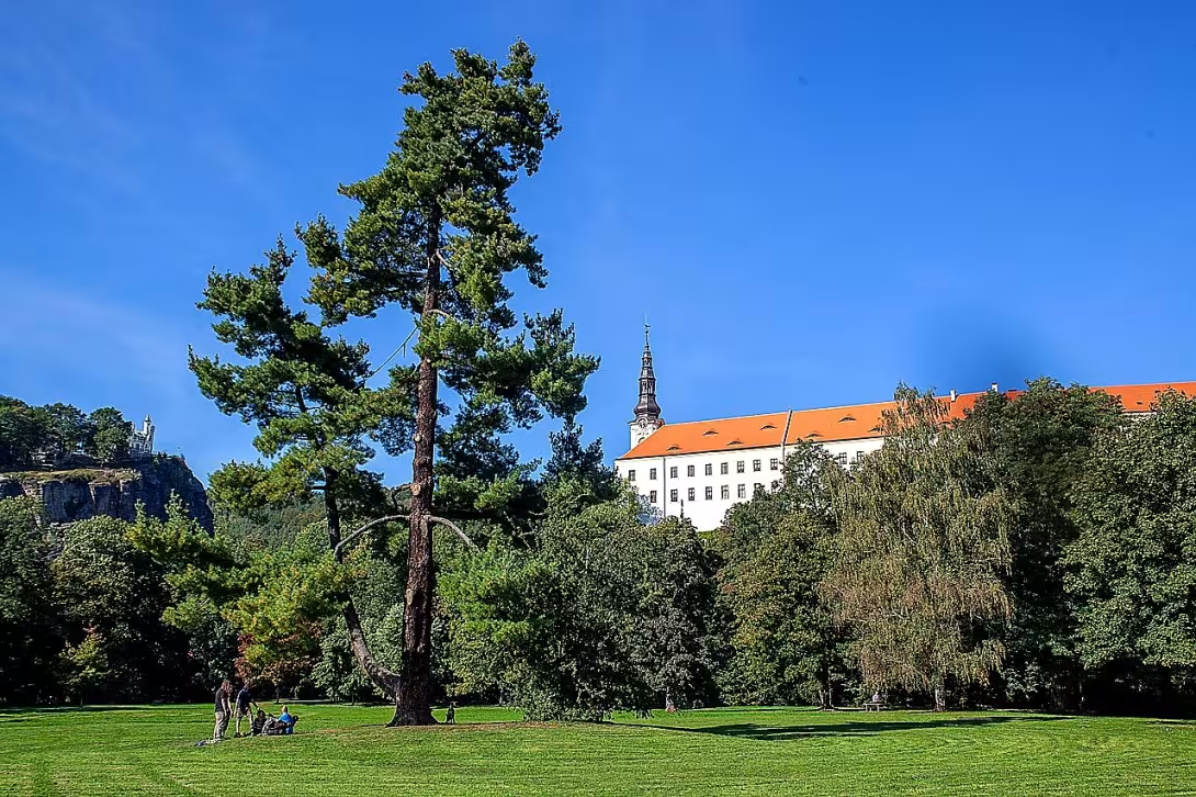
Today, Mariánska meadow is decaying in the place of the extinct city. Her name refers to the original Gothic Church of the Virgin Mary. There was a swimming pool in the 20th century, but it destroyed the flood in 2002. The current appearance of the area corresponds to the 19th century English park. The road to the meadow leads from the southern gardens of the Děčín castle through a chain footbridge built by the Thun family in 1829-1831.
This site represents a unique testimony to the fragility of medieval settlement in river terraces. A visit to Mariánska meadow combined with a museum exhibition allows you to perceive the layers of history of this defunct royal city.
Historical milestones
- 993
- First written mention of the province of Decin.
- 1267-1300
- The establishment of the royal city of Decin by the king Primohmi Otakar II.
- 1980-1989
- An archaeological survey of the site where the walls and walls of the church were exposed.
Architectural development
The city was protected by a wall and a system of water tanks and moats. In the middle there was an early Gothic church of the Virgin Mary with an adjacent cemetery. The construction was regularly arranged around the central marketplace.
Historical events
In the first half of the 14th century, the city was damaged several times by large floods, leading to its abandonment.
Owners
Royal City, later Vartenberk Manor
Points of interest
- The 13th century royal city was completely destroyed by natural disasters. - The city was founded by King Přemysl Otakar II., and in the sign carried a silver lion. - In the first half of the 14th century, residents were forced to leave the site in repeated devastating floods. The surveys from the 1980s revealed parts of the walls, the walls of the church and the graves. - The title of today's Marian meadow refers to the original Gothic Church of the Virgin Mary.
Guide
Show guide text
This text was created by artificial intelligence and has not been editorially reviewed. It may contain inaccuracies.
Welcome, distinguished visitors. You are standing in a place that may appear at first glance, but beneath your feet is a fascinating story from the days of knights and kings. Look around you at this area. You may not see any high palaces or stacked towers here, but this is where the archaeological site of the extinct medieval town of Decin is located. It's a place where history meets nature and where silence today surpasses the noise of an ancient marketplace.
Stop for a moment and imagine what this place looked like more than seven styles ago. You are located on the right bank of the Elbe River, on a low river terrace that stretches directly under the castle rock. This position was strategically ideal at the time, although it later proved problematic. The first written mention of the area dates back to nine hundred and ninety-three, but the royal city itself, which once blossomed here, was much later, in the second half of the thirteenth century.
The creation of this city was the work of one of the most important Czech monarchs, King Přemysl Otakar the other. So imagine that this place was once a royal project, a symbol of power and ambition. The King did not just build a simple settlement here, but a full city to serve as an important point in the landscape. The city was so proud of its origins that it carried in its emblem a silver lion, which was a clear sign of royal protection and high status.
Now pay attention to the surrounding space and try to map what once stood here in your mind. Even though the buildings are gone today, the archaeological surveys from the 1980s helped us determine exactly where what was located. Notice the space around you and realize that you are in the place of a former urban entity. This is where the marketplace spread, the heart of the city, where merchants, craftsmen and locals gathered. There were residential houses around the marketplace, where people lived their daily lives, and all this was surrounded by walls that protected the city from its enemies.
If you focus now on the details that were revealed in the research, you can imagine the remains of the masonry that was exposed here. Among the most important finds are parts of the walls and walls of the church of the Virgin Mary. Imagine what prayers were like in this church and how the walls made people feel safe. It's fascinating to think that these stones have been hidden in the ground for decades, waiting for modern science to reinvent them.
Let us now stop at the fate of this place because it is a tale full of dramatic twists. So why aren't you standing in the middle of a living historical center today, but in front of an archaeological site? Nature itself gives us the answer. Although the position at the Elbe River was advantageous for trade and transport, it brought with it a great risk. In the fourth century, in the first half of the 14th century, the city was the victim of repeated and devastating floods.
Imagine that scary scenario where the river level kept rising and flooding houses, marketplaces and walls. The water was relentless. The residents who built their lives here were gradually forced to leave this place. Natural disasters were so powerful that the city as a whole completely disappeared. People didn't move just a few yards, but they moved to a new suburban town where they were safer from the river's divorces. By this act, the royal city of Decin became a city lost, forgotten and gradually buried beneath layers of sediment and dust.
It's a strange and chilly notion that the whole city, founded by such a powerful monarch as Premysl Otakar the other, could only be wiped off the map because of the mood of the water. So this site is basically a monument to the struggle between man and nature in which nature won in this case. The mystery remains, as was the very process of leaving the city. Was it a sudden retreat after one major disaster, or slow emptying, as people gave up hope of refitting their homes?
When you look at this site today, feel the atmosphere of a place where the glory of the Kralevsky is connected to a silent extinction. It's a reminder of the permeability of all human beings. Even the strongest walls and the most important buildings can be swallowed up by the earth if nature's power is not in their way. The surveys of the 1980s gave us a view back to the walls of the church, but the real life of the city remains in the realm of landmarks and historical springs.
Now we invite you to look around in peace and try to complete the missing parts of this painting in your mind. Walk slowly through the space where the heart beat of the royal city once, and think about how many stories remained forever hidden in the depths of the soil.
Thank you for spending a moment with us at this unique archaeological site. We hope that you were interested in the story of Decin and that you felt a connection to the history of this region. You can now continue to explore the surroundings and explore the other sights our city offers you. We wish you a pleasant continued journey and many new knowledge. Goodbye.
Businesses nearby
Do you run a restaurant, accommodation, shop, museum, rental, wellness or other visitor service near this monument? Show yourself directly to the people heading to it — this is how they will see you in the app and on the web:
Events nearby


Zdroj akcí: otevřená data měst a obcí ČR (Národní katalog otevřených dat) a kalendář akcí Národního památkového ústavu.
Nearby
Labská řeka, děčínský zámek, řetězová lávka z let 1829–1831 a hradní skála.
Visualizations and artistic views

The visualisations are generated by artificial intelligence and serve as inspiration.
Photos from the area
Real photos taken near the monument


Zdroj a licence jsou uvedeny u každého snímku.
Tips from visitors
No tips yet. Be the first!
Log in and add your tip.
Sources and literature
Photos: Tadeáš Bednarz / CC BY-SA 4.0 — Wikimedia Commons. The author and licence also appear when you hover over the image.
Faktickým podkladem tohoto textu byl článek na Wikipedii, jehož autory jsou přispěvatelé Wikipedie. Článek je dostupný pod licencí CC BY-SA 4.0.
Location on the map
More monuments – Děčín I-Děčín
Show all in the municipality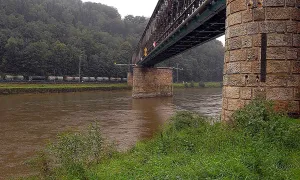
Příběhy a pověsti
Legendy, pověsti a příběhy spjaté s touto památkou

Fotografie návštěvníků
Zatím žádné fotografie. Buďte první, kdo přidá fotografii z návštěvy!
Log in a přidejte svou fotografii nebo hodnoťte.
Za ověřenou návštěvu v aplikaci získáte víc bodů — poznáme podle GPS, že jste na místě.
Reviews and comments