



Kozly Hillfort
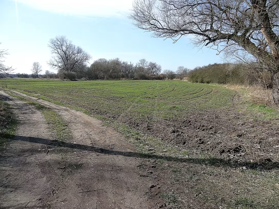
The castle Kozly is an archaeological site on the left bank of the Elbe near the village of Tisice in the district of Mělík. The locality was inhabited in the period of the Hallatians and then in the early Middle Ages. Its importance lies in a unique position in the river meander, which ensured the natural protection of the fortified area.
There are few reports of the oldest history of the place. The surface findings of ceramics confirm the settlement at the time of the Halštat, when in the Czech countries there was development of a fortified culture and consolidation of the social hierarchy. The subsequent use of the site in the early Middle Ages corresponds to the period of forming early feudal structures and building fortified centres. However, the precise dating of the creation of the fortification itself remains unclear without more detailed archaeological research.
The area was approximately 200 metres long and between 60 and 80 metres wide. The original form of the fortification is not known, but it is assumed that the walls surrounded the entire perimeter of the site. The construction material was used for optics and wooden construction. Their existence is evidenced by the discovery of carbon and dead clay discovered in the late nineteenth century. Today, the remains of the fortifications are only visible as a field wave and remains of the ditch on the west and northwest side.
The nineteenth century, when the Elbe flow was regulated, brought a significant change in the shape of the site. Originally, the fort was located on the right bank of the river, which was seduced by these modifications into the current trough. The original strategic position was used by a broad meander and surrounding wetlands, which protected the three-party seat. Access to the premises was probably only possible from the east, where there is supposed to be a hackway leading through the then soggy terrain.
Today the castle Kozly is protected as a cultural monument. For visitors, it represents a place with visible terrain tracks of prehistoric and early medieval settlement in typical Polabi landscape. Visiting the site offers an opportunity to explore the history of the settlement of river terrain and to understand how people in the past used the natural properties of the landscape to build their settlements.
Historical milestones
- around 800 BC l.
- The settlement of the site at the time of the Halštats
- around 800
- Use of the site in the early Middle Ages
- 1890
- Archaeological finds of carbon and bulky clay
- 1895
- Control of Elbe flow and change of position of the fort towards the river
Architectural development
The fortified area was approximately 200 metres long at a width of 60 to 80 metres. The original form of the walls is not exactly known, but it is assumed that they surrounded the entire perimeter of the site. The building material included opposia and wooden structures, whose existence is indicated by the discovery of carbon and dashed clay.
Historical events
In the nineteenth century, the flow of the Elbe river was regulated, which changed the position of the castle towards the river bed. At the end of the nineteenth century, opus stones were found at the site of the walls and traces of a fire in the form of shrouded dirt and carbon.
Points of interest
- The fort is located on the left bank of the Elbe near the village of Tišice, originally lying on the right bank before the river was regulated in the nineteenth century. - The unique location in the river meander ensured the natural protection of the fortified area, which was protected from three sides by the surrounding wetlands. - The construction of walls has been used opka and wooden structures, whose existence is evidenced by the discovery of carbon and bulky clay from the late nineteenth century. - The area was approximately 200 metres long and between 60 and 80 metres wide. - Access to the castle was probably only possible from the east side, along a hanger road leading through the then soggy terrain.
Guide
Show guide text
This text was created by artificial intelligence and has not been editorially reviewed. It may contain inaccuracies.
Welcome to Castle Kozly. Stop for a moment, take a breath and feel the space around you. You are standing in a place that may at first glance look like a quiet landscape near the village of Tišice, but under your feet and in the surrounding terrain sleeps a millennium of human destinies. Look towards the Elbe River. It was this silver ribbon of water that was the key to the existence of this place, and at the same time it became the main figure in the story of landscape change. You see before you the archaeological sites that tell us about the people who were here looking for safety, strategic advantage and home in times when the world was much more dangerous and wild than it is today.
Let us now return together in time to understand why these hills and banks of the river were so important. The history of this place is not one continuous story, but rather layers that have been placed on each other by different generations. The first significant traces of human presence here are about eight hundred BC. It was the age of the Halštats, the period of early iron, when the first complex companies formed in Europe and fortified centres were formed. Imagine the people back then who worked so hard to adjust the terrain to make it a safe place for their families and livestock.
But the Goat story doesn't end here. After a long period of silence, the site woke up again in the early Middle Ages, again around the year eight hundred years ago. It's fascinating to think that the same place, with similar strategic advantages, has attracted people again after over a thousand years. Why here? The answer lies in the architecture of the landscape itself. Even if you can't see the walls or the massive gates today, feel the logic of defense itself. The fort was brilliantly situated in the river meander. Look how the river flows around the terrain. This natural loophole of the Elbe, combined with the surrounding wetlands surrounding the area from three sides, created an almost inaccessible fortress. The attackers would have to eat through deep mud and rushes, while the inhabitants of the castle had a perfect view of everyone who came near them.
Now pay attention to the surrounding terrain. Although time and erosion have erased clear contours of fortification, try to reconstruct in your mind what this place looked like. Note the slight elevation and the way the landscape meets water. It was here in the past that the forests and cabin walls were built, which protected the inner area of the castle. Although today we do not know the specific names of architects who designed this place, their work was based on a deep understanding of nature. They took advantage of everything the surroundings offered: clay, wood and, above all, the strategic location of the river, which served as the main transport artery of that time.
When we think about the people who lived here, we have to admit that their names didn't go down in history. We know no great personalities, no name of ruler or famous warlord. And that's where the Goat magic lies. It's a monument to anonymous people. Imagine a day over a thousand years ago. The sounds of striations in the dirt, the smell of fire smoke, the noise of children and animals. Around the year a thousand eight hundred and ninety, archaeologists found carbon residue and dashed dirt. These tiny findings are like pieces of broken mirror that show us a piece of truth about everyday life. Burnt clay can tell us about craftsmanship, the melting of metals, or the tragic fires that the fort may have encountered over the centuries.
Now I want to take you to one of the greatest mysteries and the most fascinating facts of this place. Look at the Elbe River again. You're standing on her left bank today. It seems natural that the fort lies here. But the truth is much more unexpected. If you could move to the year one thousand eight hundred ninety-four, you would find that the castle Kozly is on the right bank of the river. Yes, you heard right. The entire fortification was on the opposite side of the water.
How is that possible? The answer gives us the end of the nineteenth century. In the year one thousand eight hundred ninety-five, there was extensive regulation of the Elbe flow. At the time, people wanted to tame the river, level its trough, to make sailing easier, and a landscape less prone to flooding. The engineers changed the course of the river and the fort, which was protected by the right bank for millennia, suddenly found itself on the left. It is an incredible example of how human intervention in nature can change the geographical reality that lasted thousands of years in a few months. This change in the position of the fort towards the river gives the place a special, almost surreal dimension. You're standing where the geography has shifted under your feet.
If we were to look for a great mystery in Goat, it is a question of precise dating fortifications. Even though we know about the settlement in the period of the Hallatians and the early Middle Ages, the exact moment when the main defence elements were built remains unclear without deeper archaeological research. It's an open book from which we only read a few pages. Who exactly lived here in the early Middle Ages? Was it a local community seeking refuge, or a strategic point in the region's wider defence system? These questions remain in the air, like fog over the morning Elbe.
Imagine now how two periods intersect in this space. On the one hand, there are people from the period of iron and the early Middle Ages who lived with the river in awe and used its natural loopholes to protect it. On the other hand, there are nineteenth-century people who perceived the river as a machine that can and must be repaired and compared. Kozly is where these two worlds meet.
If you look around now, try to perceive the atmosphere of this place. You may feel a slight breeze coming from the river or hear the noise of leaves. These are the same sounds people heard 2,000 years ago. Even though the walls are gone and the walls are washed with time, the spirit of this place remains. It's a place about survival, strategic thinking, and constant change.
Let us now slowly end this part of our journey. I ask you to walk around in peace now. Take your time. Try to imagine the invisible walls and wetlands that once divided the safety of the inner castle from the unknown outside world. Look at the Elbe trough and think about how powerful water and human will can change the face of the earth.
Thank you for joining me on this short journey to the depths of time. I hope you found not only archaeological clues in Kozlů, but space for your own imagination. I wish you a pleasant exploration of the rest of this fascinating location and a beautiful day spent in the embrace of history. Goodbye.
Tips for visitors
The best time to visit is spring or autumn, when vegetation is lower and the terrain of the archaeological site is clearer. In summer the location may be covered with high grass, which makes it difficult to move and observe the terrain inequalities of the castle.
The location is close to the village of Tišice. Check public transport in the current connection search for the destination stop in Tišice.
Due to the nature of the site take with you fixed shoes to the field and repellent, especially if you plan to walk near the Elbe River and in the meadow landscape. Don't forget enough fluids, there's no service on the premises.
For photography is the ideal time shortly after sunrise or before sunset, when the oblique light better paints the terrain walls and remains of the fortifications. Focus on the details of the relief, which are unique in the flat landscape of Polabi.
For families with children, the location is suitable as the destination of a trip related to nature. In the surrounding area you can explore the banks of the Elbe River and the Polabi Landscape, which offer space for easy tourism and observation of local fauna and flora.
Frequently asked questions
Can the monument be visited?
This is an archaeological site. Often there is little to see on the ground and the land may be private. We have not verified access. According to the heritage register the structure is in poor condition – do not enter it and take care nearby.
Where is the monument?
Location: Středočeský kraj. The map on this page shows the exact spot.
Why is the monument protected?
It is listed in the Central List of Cultural Monuments of the Czech Republic as a cultural monument (register no. 1000139055).
Businesses nearby
Do you run a restaurant, accommodation, shop, museum, rental, wellness or other visitor service near this monument? Show yourself directly to the people heading to it — this is how they will see you in the app and on the web:
Nearby
The village of Tisice, River Elbe, the surrounding landscape of Polabi.
Accommodation nearby
Trips and activities nearby
Guided tours, tickets and activities nearby from GetYourGuide
Affiliate link: if you buy from the partner, we may receive a commission. The price for you does not change.
Search tours and activities →Themed route
Thematic cruise route around the archaeological site Kozly
1. Archaeological site Kozly - Type: Archaeological site - Why is it worth visiting: The Kozly is one of the most important prehistoric settlements in the Czech Republic. Visit this site and explore its rich history, which dates back to the period of old iron age.
2. River Elbe - Type: Natural environment - Why is it worth a visit: After exploring the site we will look to the Elbe River, which forms a lively landscape around the Goat. It is an ideal place for relaxation and a view of the vast landscape of Polabi.
3. Polabi Landscape - Type: Natural environment - Why it is worth a visit: The Polabi Landscape can be explored during a short walk. This area offers views of the diverse flora and fauna that are typical of such lowland areas.
4. Municipality of Tisice - Type: Local center - Why is it worth a visit: After visiting archaeological and natural attractions you can return to the village of Tišice. Here you will find the opportunity to relax, find out more about the history of the region or visit local businesses.
This route will guide you through the rich history and natural beauty surrounding the archaeological site Kozly.
Seasonal recommendations
In spring, there is an emerging nature and a fresh greenery that creates an interesting contrast to the decaying state of the site. Soft spring light helps to better understand the details of the terrain and the remains of the buildings. We recommend moisture-resistant shoes for soggy soil and a visit in the morning when the current of visitors is still moderate.
The summer season brings sharp sun and burnt grass, which deepens the feeling of abandonment in this place. The atmosphere is hot and dry, which can represent the crueliness of history. It is advisable to come very early in the morning to avoid the greatest crowds and the highest heat. Don't forget light clothes, hat and plenty of fluids.
Autumn covers the memory with golden colours and frequent fog gives the site a mysterious and melancholy touch, which approaches its bad condition naturally. The best time to visit is the late afternoon, when the low sun dramatically illuminates the rest of the structures. Because of the weather, reach for layered clothes.
In winter, the site is covered with snow, which unites the landscape and reduces all sounds, creating a sense of absolute calm. The contrast between the white surface and the dark remains of the stones is very significant. For a shorter day and limited opening time, plan to arrive around noon and dress up in warm, waterproof layers.
Visualizations and artistic views


The visualisations are generated by artificial intelligence and serve as inspiration.
Photos from the area
Real photos taken near the monument


Zdroj a licence jsou uvedeny u každého snímku.
Tips from visitors
No tips yet. Be the first!
Log in and add your tip.
Sources and literature
Photos: MartinVeselka / CC BY-SA 4.0 — Wikimedia Commons. The author and licence also appear when you hover over the image.
Faktickým podkladem tohoto textu byl článek na Wikipedii, jehož autory jsou přispěvatelé Wikipedie. Článek je dostupný pod licencí CC BY-SA 4.0.
Location on the map

Příběhy a pověsti
Legendy, pověsti a příběhy spjaté s touto památkou

Fotografie návštěvníků
Zatím žádné fotografie. Buďte první, kdo přidá fotografii z návštěvy!
Log in a přidejte svou fotografii nebo hodnoťte.
Za ověřenou návštěvu v aplikaci získáte víc bodů — poznáme podle GPS, že jste na místě.
Reviews and comments