



Nalžovické Podhájí Hillfort
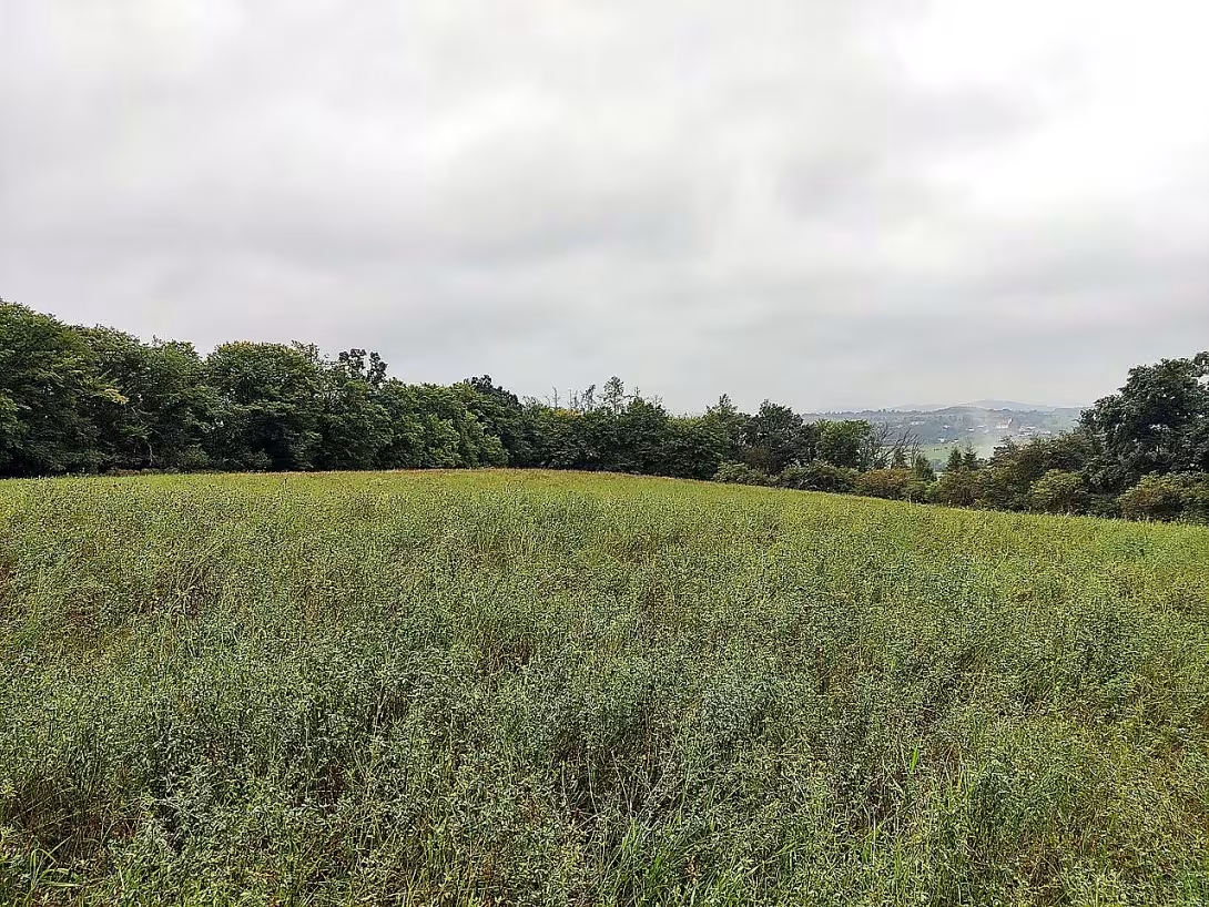
Nalžovické Podhájí is an ancient and early medieval castle in the village Nalžovice in the district of Příbram in the Central Bohemian region. The main phase of its use took place from the end of the 10th to the first half of the 11th century, when it probably served as a premeditated supporting point. The building is today protected as a cultural monument.
The settlement of this place has been certain since the eneolite. The only piece of pottery found in the ancient history is evidenced by the fact that it probably came from the period of the Knoviz culture. The second and main stages of living are in the turn of the 10th and 11th centuries. During this period, the power of the Princes of the Přemysk was consolidated in the Czech Republic. A network of strategic castles and support points for defence and administrative control of the territory was built. The operation of the fort at this time was likely provided by several service settlements.
The archaeological site is located in the top part of the island square at an altitude of 378 metres. From the east, there is a stream of Mojk and its tributary of Loužek. The fort with an area of 1,4 hectares is 180 × 105 metres. The fortification in the northwest part formed a moat about four metres wide and a deep one meter. Five meters behind him was a wooden clay wall of oak beams. It was amplified by a front wall of dry laid stones between 160 and 200 centimeters wide. On the north-west side, there could be a front line, but any fortifications of which are unrecognizable. The sides of the bay protected steep slopes. Traces of fortifications are very little visible here, which also complicates the terraced adjustment of slopes associated with the journey to the valley.
The collapse of the wall caused a massive fire. This was highlighted by a large number of carbons, sunburned stones and burnt soil. From the original fortification to this day, he survived in the form of a steep line. In 1950, Libuše Jansová led archaeological research at the castle. It examined the area of 239 square meters, not all probes being examined to the ground.
The location lies in Benesov hill and represents an important element of early medieval infrastructure. It is accessible as a cultural monument in natural terrain.
Nalžovické Podhájí offers a view into the period of Czech state formation and strategic layout of the territory. Visiting this place allows you to observe the remains of the early medieval fortification right in the field.
Historical milestones
- eneolit
- First settlement
- around 2500 BC l.
- Likely period of the existence of the Chilean culture
- End of the 10th century
- The beginning of the main phase of the use of the castle
- First half of the 11th century
- The end of the main phase of the use of the castle as a relic point
- 1950
- Archaeological research led by Libushi Jansa
Architectural development
The fortification consisted of four metres wide and one metre deep moat along with a wooden clay wall made of oak beams. The wall was reinforced by a front wall of dry laid stones with a width of 160-200 centimeters. The wall's demise was caused by a massive fire, which highlights the amount of carbons and sunburned stones.
Historical events
End of the 10th to first half of the 11th century: The second phase of the settlement and the probable operation of the castle as a premeditated supporting point.
Points of interest
- The settlement is certain since the eneolite and the oldest finding is a fraction of ceramics from the period of the Knovisi culture. - The main use of the fort took place from the end of the 10th to the first half of the 11th century as a submissive supporting point. - The fortification in the northwest part consisted of four meters wide and one metre deep moat and a wooden clay wall made of oak beams. - The wall's demise caused a massive fire, which alters the amount of carbons and sunburned stones. - In 1950, Libuša Jansa led archaeological research at the castle.
Guide
Show guide text
This text was created by artificial intelligence and has not been editorially reviewed. It may contain inaccuracies.
Welcome to Naljovický Podvojí. You have just entered a space that will not tell you stories through tall walls, monumental towers or decorative statues, but through the very shapes of the earth and the silence that exists here. You are standing at a strategic point, on a sharp point, which has been used since time immemorial as an observer and a refuge. Look around you. You can see the vast landscape of the Central Bohemia Region, but try to look at it differently. Imagine it not as today's fields and forests, but as a dynamic environment that has been changing for millennia. Feel the atmosphere of this place where every piece of land can hide a secret from thousands of years ago.
This mountain is not just part of the natural relief. It is a witness to the human effort that began at a time when the world had just learned to control metals. The history of this place is deeper than it might seem. Even at the time of eneolite, that is, when mankind began experimenting with the first use of copper, someone here decided that this is the right place. That's not just an assumption. Archaeological findings, such as the tiny but incredibly valuable piece of pottery from the time of the Chinese culture, clearly tell us that people lived here, worked and sought safety about two thousand five hundred BC. Imagine the first settlers to look here at the same sky as you, looking for protection from the unknown in this terrain.
But let us now move forward several thousand years in time, into the period that gave this place its greatest historical weight. Now pay attention to the idea of the end of the tenth century. This is the moment when the power center of our state was formed. Nalžovické Podhájí at this time became one of the important supporting points of the Přemyslivov dynasty. It wasn't just a settlement, it was part of a wider defense network system to protect the rising power of the royal line. During this period, for approximately 50 years, the main phase of the use of the castle took place here. Imagine this place as a living center that wasn't lonely. In order to fulfil its strategic role, it has been maintained by several service settlements, which are probably inhabited by people ensuring the needs of this fortified point. It was a place of communication, business and defense.
Now look at the terrain itself under your feet and around you. Even if you no longer find wooden palisades or stone walls that once protected the inhabitants, the trace remains in the ground. Notice how the slope of the slope changes and how the ground suddenly falls or changes its shape in some places. If you now focus towards the northwest side, you can see evidence of ancient engineering art. There was a massive moat in this section. Although it is now only part of the landscape, its dimensions are still impressive. He was four meters wide and one meter deep. Imagine the enormous difficulty of working, where people, by hand, using simple tools, dug up this massive barrier to make it harder for the enemy. This ditch was not just a hole in the ground, it was a symbol of the power and determination of the people who lived here.
To learn anything about this place, we need to go back to recent history, namely, 1950. That's when fundamental archaeological research under the leadership of Libuš Jansa began here. It is precisely because of her patience, precision and ability to read in clay that we can today reconstruct this history. Imagine the archaeologists, both in the silence of the morning, with little brushes and shoulder blades, uncovering layer by layer to tell us about the Chinese ceramics or the imaginary administration of this territory. Libuš Jansa's work allowed us to understand that what you see as an ordinary hill is actually a complex archive of human destiny.
You may be interested in one thing that remains unclear here. How is it that this place has become so important in such different times? Why did people come back here thousands of years after the first settlers left their ceramic vessels? It's about how unique this is. It offers a combination of the natural advantages of the terrain and strategic location, which has not resisted even changing political situations. This continuity of settlement, from the age of eneolithic to the early Middle Ages, is one of the greatest mysteries and at the same time the greatest evidence of the power of this place.
Now, however, I will no longer hold you in place. I suggest you continue your walk on the surrounding terrain. Try to see every change in the tilt of the earth and every trace left by the human hand centuries ago. Take a look at the surrounding vegetation and try to imagine what this place looked like at the time of its greatest glory, when the service settlements and the castle were working here as a key point for building the state. Thank you for joining us on this short journey through time. We wish you a pleasant continuation in exploring this fascinating place.
Tips for visitors
The best time to visit is the late spring or early autumn season when nature is the most lively and temperatures are pleasant for walking in the field. The sunny days make it easier to see the shapes of the fort and the structure sharpness.
You can reach the monument by car and public transport; check the current connection in the internet search engine.
Bring comfortable shoes suitable for uneven terrain and plenty of water. For families with children, the place is interesting as a space for discovering traces of ancient history in nature, but it is necessary to ensure safety while moving around ruins.
For the best photos we recommend to use the low sun during the morning or evening hours, which will highlight the relief of the castle. In the surroundings you can observe the beauty of Benešov hill and watch the flow of the streams Mojk and Loužek.
Frequently asked questions
Can the monument be visited?
This is an archaeological site. Often there is little to see on the ground and the land may be private. We have not verified access.
Where is the monument?
Location: Nalžovice, Středočeský kraj. The map on this page shows the exact spot.
Why is the monument protected?
It is listed in the Central List of Cultural Monuments of the Czech Republic as a cultural monument (register no. 1000138748).
Businesses nearby
Do you run a restaurant, accommodation, shop, museum, rental, wellness or other visitor service near this monument? Show yourself directly to the people heading to it — this is how they will see you in the app and on the web:
Nearby
The monument lies in Benesov hill, which is surrounded by the river Mojk and its tributary Loužek from the east.
Accommodation nearby
Themed route
Nalžovické Podhájí - archaeological site, main destination trip. Here are preserved the remains of ancient settlements that allow a glimpse into people's lives thousands of years ago; there is an information board and a short exposure of artifacts.
The river Mojk - a natural watercourse, located east of the bottom and surrounding it. A walk along the Mojk (about 400 m from the location) offers a quiet environment, the possibility to observe local vegetation and small fauna, while underlining the historical context of settlement in water resources.
Attendance Loužek - smaller tributary Mozek, lies further downstream (about 300 m from Mozek). The puddle represents a typical natural feature of Benešov's hills; Its shores are surrounded by forest trees, providing a pleasant place to rest and contemplate the connections between water and primordial culture.
Seasonal recommendations
Spring: In the spring, the archaeological remains of Nalžovický Poděží wake up together with nature. The fresh green meadow and the first flowers form a fresh contrast to the stone ruins. Lighting is soft during this period and very suitable for shooting details. We recommend taking layered clothes because the morning cold can still be felt. It's best to arrive in the morning when the air is the cleanest.
Summer: The summer visit offers a full bloom of vegetation and long days that allow you to explore the surroundings in peace. The sun shines the strongest, highlighting the structure of ancient stone elements. Due to higher temperatures and possible crowds of visitors it is best to come right after opening or late afternoon. Don't forget the hat, plenty of water and solid shoes suitable for uneven terrain.
Autumn: The autumn season brings a melancholy atmosphere to the site, complemented by morning fog stretching through the valley and changing colour of leaves. The golden and red tones of the surrounding landscape perfectly match the atmosphere of the historic ruins. It is necessary to prepare for wet conditions, so choose a waterproof jacket and shoes with good grip to avoid slipping on a wet surface.
Winter: In winter, the ruin is crude and majestic, especially if it is covered with snow or freezing. Leather trees reveal views of archaeological details that are otherwise hidden in dense vegetation. Due to short days and cold we recommend very warm clothes and possibly a flashlight. It is good to check in advance whether the path to the monument is safe and passable at a given time.
Visualizations and artistic views


The visualisations are generated by artificial intelligence and serve as inspiration.
Photos from the area
Real photos taken near the monument


Zdroj a licence jsou uvedeny u každého snímku.
Tips from visitors
No tips yet. Be the first!
Log in and add your tip.
Sources and literature
Photos: Ppap430 / CC BY-SA 4.0 — Wikimedia Commons. The author and licence also appear when you hover over the image.
Faktickým podkladem tohoto textu byl článek na Wikipedii, jehož autory jsou přispěvatelé Wikipedie. Článek je dostupný pod licencí CC BY-SA 4.0.
Location on the map


Příběhy a pověsti
Legendy, pověsti a příběhy spjaté s touto památkou

Fotografie návštěvníků
Zatím žádné fotografie. Buďte první, kdo přidá fotografii z návštěvy!
Log in a přidejte svou fotografii nebo hodnoťte.
Za ověřenou návštěvu v aplikaci získáte víc bodů — poznáme podle GPS, že jste na místě.
Reviews and comments