



Radná Hillfort
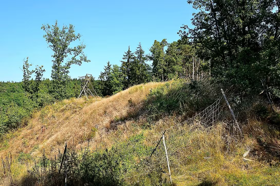
Radná, also known as Old Castle, is a prehistoric castle on the island over the Berounka river in the cadastral area of Olesná near Radnice in Rokycany district. The locality was inhabited in the Bronze Age and later again in the early Middle Ages. Since 1964, it has been protected as a cultural monument.
The oldest history of the place has been preserved by a few reports based on archaeological findings. The first survey took place in 1931 and confirmed the settlement in the late days of the Bronze and Halštat. The findings of ceramic fragments show that the fort was used in the second half of the ninth century, i.e. during the period of formation of the early medieval state in Czech countries.
The total area of the fortified area is 4.5 hectares. The core of the site is an acropolis of 200 times 50 meters, which occupies an area of 1.2 hectares. This space was protected by a massive clay wall; until today, it has been preserved for 40 metres long and up to six metres high. On both sides of the wall there are deeps, which probably served as moats. The defensive system is supplemented by two more mounds which overload the island and protect the foothills.
Archaeological research in the places where the road falls to the river revealed the remains of the soil with smothered floors and cellars. The largest of these buildings had a floor plan of 6 times 5 meters and disappeared by fire. This is indicative of the findings of burnt grain, ceramic containers and weight of weaving condition. The inhabitants of the fort were devoted to agriculture; they have grown common wheat and duodenum, millet, peas, lentils and horse beans. They kept pigs, cattle, horses and goats.
In 2023, during the insensitive expansion of the forest road, significant damage to this archaeologically valuable site occurred. Today, the area of the castle is freely accessible to the public following a yellow marked tourist route leading from the Holy Cross.
Radná is an important document of prehistoric and early medieval settlement in the Plaské horkatina. Visiting this place offers the opportunity to become acquainted with the history of fortified settlements and the way our ancestors live in a naturally protected position above Berounka.
Historical milestones
- 1931
- Archaeological survey of the castle dates back to the Bronze and Hallatian times.
- 1964
- The location was declared a cultural monument.
- 2023
- Significant damage to the archaeological site in the insensitive expansion of the forest road.
Architectural development
The fort had acropolis 200 times 50 meters, protected by a massive clay wall preserved up to a height of six metres. The outer fortifications consisted of two other mounds which overloaded the island. The internal building consisted of half-grounds with suffocated floors and cellars, one of which was destroyed by fire.
Historical events
1931: First archaeological survey of the site. 1964: Announcement of a cultural monument. 2023: Damage to the site in expanding the forest path.
Points of interest
- The castle Radná is also known as Old Castle and is located on the island over the Berounka River. - The locality was inhabited in the Bronze Age and later again in the early Middle Ages, and since 1964 it has been protected as a cultural monument. - From the original massive clay wall until today, a section of 40 metres long and up to six metres tall has survived. - Archaeological research revealed the remains of the soil, the largest of which was destroyed by fire, as evidenced by the findings of burnt grain, ceramics and the weight of the weaving state. - The inhabitants of the castle were engaged in agriculture and animal husbandry such as pigs, cattle, horses and goats.
Guide
Show guide text
This text was created by artificial intelligence and has not been editorially reviewed. It may contain inaccuracies.
Welcome to the historical monument of Radná, an archaeological site full of secrets and beauty, which stretches over the Berounka River in the cadastral territory of Olešná near Radnice. You're standing in front of a place where the past meets the present, and every stone tells its own story.
Radná is an ancient castle whose roots extend back to the Bronze Age. This historic area was later resettled in the early Middle Ages, namely in the second half of the ninth century. Here, people from different ages and cultures could meet, whose lives were shaped by this valley. An area of 4.5 hectares is home to acropolis and a system of three quarries with moats which were used for defence. These structures are witnessing a rich history where people took care of farming and protecting their home.
Let's move closer and look up at these boulders. Notice their power, which will welcome you from far away. The clay walls, although partially destroyed by time and negligence, are still talking about the strategic location of this castle. This defence system was key to protecting the population from enemies and natural disasters.
Although particular historical figures associated with this site remain unknown, their presence is felt in every stone. These places witnessed the lives and efforts of many generations to keep their community alive.
The interesting thing about this castle is the popular name "Old Castle," which suggests the mythical and legendary nature that many associate with this place. This name reflects not only its historical significance, but also the imagination of people who once settled here.
Since 1964, Radná has been protected as a cultural monument. However, in 2023 the site was damaged in the insensitive expansion of the forest road, which underlines the importance of protecting and caring for our cultural heritage.
Now that you've seen this memory, the invitation is to take a deeper look at its stories. Explore the surrounding landscape and let your spirit fly on the waves of time. Radná has much to offer to those who are willing to listen to its silent storytellers.
Thank you for your visit and we hope that this guide has opened the door to the fascinating world of our common past. Enjoy your trip to Radna!
Tips for visitors
To visit, choose spring or autumn months when vegetation is not so dense and the terrain inequalities of the castle are better visible. In summer, the location can be covered with high grass and bushes.
The location is located in the terrain where the paved road does not lead. It is recommended to park near the village Plana or Escape by the Holy Cross and take the rest of the trip on foot through the field or forest roads.
Due to the poor state of the monument and the more demanding terrain take fixed shoes to nature and long pants. Don't forget enough fluids and repellent because it is a freely accessible archaeological site without background.
The best lighting conditions for capturing the island above Berounka are during the golden watch, i.e. shortly after sunrise or before sunset. Focus on the natural landscapes and views of the river valley.
In the surroundings there is a fort in the Plaské měhorkatina which offers space for easy hiking. For families with children, the trip is suitable as a lesson in the history of nature, but due to the absence of infrastructure it is necessary to ensure safety in the terrain.
Frequently asked questions
Can the monument be visited?
This is an archaeological site. Often there is little to see on the ground and the land may be private. We have not verified access. According to the heritage register the structure is in poor condition – do not enter it and take care nearby.
Where is the monument?
Location: Plzeňský kraj. The map on this page shows the exact spot.
Why is the monument protected?
It is listed in the Central List of Cultural Monuments of the Czech Republic as a cultural monument (register no. 1000157261).
Businesses nearby
Do you run a restaurant, accommodation, shop, museum, rental, wellness or other visitor service near this monument? Show yourself directly to the people heading to it — this is how they will see you in the app and on the web:
Nearby
The fort is located in the Pláské horkatina above the river Berounka, near the village Plana and the Újezda near the Holy Cross.
Accommodation nearby
Trips and activities nearby
Guided tours, tickets and activities nearby from GetYourGuide
Affiliate link: if you buy from the partner, we may receive a commission. The price for you does not change.
Search tours and activities →Themed route
1. Plana (village) - The entry point of the trip, which serves as a base for starting the trip. 2. Radná (archaeological site) - The main destination of the route where you can explore fascinating remains from ancient times. 3. Plasma hill (landscape) - Walk through the wavy terrain offers pleasant movement in nature and views. 4. Berounka (river) - A rest stop by the water in the valley below the castle. 5. Departure at the Holy Cross (village) - Final stop of the trip in a quiet rural environment.
Seasonal recommendations
Spring: For a spring visit, look forward to the awakening surrounding vegetation and softer sunlight, which highlights the structure of the site. Due to the poor condition of the terrain, however, prepare for muddy surface and increased humidity. I recommend you choose waterproof shoes and layered clothes to protect you from changing weather. There are fewer visitors in this period, so you can enjoy the place in peace and quiet.
Summer: The summer season brings intense sun and dry soil, which can cause dust in exposed structures. The atmosphere is more lively in the main summer season, but due to high temperatures and a rush of tourists it is best to arrive right after opening, ideally in the morning. Don't forget the headgear, enough drinking water and solid shoes that are necessary for safe walking on uneven and neglected terrain.
Autumn: Autumn moons offer a melancholy atmosphere with morning fog and golden shades of the surrounding countryside. Lighting is very interesting at this time, especially in the afternoon when the sun shines below. Due to increased humidity and frequent rains it is necessary to have a waterproof jacket and high-quality shoes with good grip. The roads may be slippery, so be more careful when looking.
Winter: Winter visit offers a quiet and rough view of archaeological remains in the landscape without leaves. The light is weak and the days are short, so plan a visit around noon to use maximum daylight. Due to the poor state of the monument and possible frost, it is critical to have very warm and robust clothes. Watch out for possible snow or ice, which can significantly make it difficult to move in more difficult terrain.
Visualizations and artistic views


The visualisations are generated by artificial intelligence and serve as inspiration.
Photos from the area
Real photos taken near the monument


Zdroj a licence jsou uvedeny u každého snímku.
Tips from visitors
No tips yet. Be the first!
Log in and add your tip.
Sources and literature
Photos: Petr Kinšt / CC BY-SA 4.0 — Wikimedia Commons. The author and licence also appear when you hover over the image.
Faktickým podkladem tohoto textu byl článek na Wikipedii, jehož autory jsou přispěvatelé Wikipedie. Článek je dostupný pod licencí CC BY-SA 4.0.
Location on the map
More monuments – Plzeňský kraj
Show all in the region

Příběhy a pověsti
Legendy, pověsti a příběhy spjaté s touto památkou
Fotografie návštěvníků
Zatím žádné fotografie. Buďte první, kdo přidá fotografii z návštěvy!
Log in a přidejte svou fotografii nebo hodnoťte.
Za ověřenou návštěvu v aplikaci získáte víc bodů — poznáme podle GPS, že jste na místě.
Reviews and comments