



Rudné doly na Bludné Mine
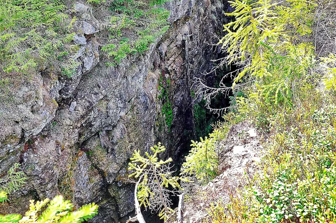
Rudné doly na Bludné represents an extensive assembly area in the Erzgebirge Mountains. They are an important example of the historical mining of tin and iron ores. The locality lies in the cadastral territory of Potoučky in the district of Karlovy Vary and since 2013 is protected as a cultural monument of the Czech Republic.
Mining in this area has been known since the 14th century. The first written mention of the loan to the miners from Saxony dates back to 1531. The work continued throughout the Middle Ages and was not stopped by a 30-year war. The activity was restored in the first half of the 18th century and the mines operated until the First World War. The historical importance of the site underlines its inclusion in Geopark Egeria.
Geologically, the territory is bound to the Blaten granite flesh and its metamorphosed mantle made up of phylites, roulls and scrolls. The red veins contained mainly tin, hematite, manganese, silver and cobalt and showed a slope of 65 to 76 degrees. In the past, the miners used a specific name for red lenses: vertically oriented, they called false and horizontally stored bellies. In the 16th century, when mining culminated, the method of planting fire was used. The rock was heated and then cooled sharply, allowing for effective material disconnection.
The most important works include the mine Zuzana, based in the 16th century on the same-name vein. Its part is over 150 metres long and up to ten metres deep surface quarry, divided by pillars in several parts. In the deepest parts, there are still traces of fire planting in three floors above. The other important mines were Vavranec, God the Father, the Holy Spirit or the Expensive fur. The mining of iron ores is represented by the mines of Gustav, Help of God and Francis. Mine Help of God, evidenced in 1562, used the groom's pit until 1884. The drainage of iron-ore mines was provided by a two-mile-long hereditary stol František.
Today, the location is accessible through the unmarked Bludna learning route of 8 kilometres long, which follows the teaching path of the Stallion. The route includes a stop at the dear fur mine, down the Help of God, the Blatenské trench and the extinct Mines of Bludna. In the field there are still visible pinky strokes, buried in the mouth of the chute, large drains and sinks after mining.
Rudné doly na Bludné is a unique testament to ore mining technologies and mining development in the Erzgebirge Mountains. Visiting this area offers an authentic view of the history that has shaped the landscape for centuries.
Historical milestones
- 1531
- The first written mention of the loan to the miners in Saxony.
- 1817
- Termination of mining at the Zuzan mine.
- 2013
- Declaration of the region for the cultural monument of the Czech Republic.
Architectural development
Mining works have been developed gradually since the Middle Ages, with extensive stacks and surface quarry systems being built in the 16th century. They used methods such as planting fire in the corridors, which allowed for effective unbundling of rock. Surface rigs, such as the Zuzana vein, were over 150 metres long and were divided by pillars.
Historical events
1531: First written mention of the loan to the miners of Saxony. 1817: Termination of mining at the Zuzana mine. 2013: Declaration of the region for the cultural monument of the Czech Republic.
Points of interest
- The area has been protected as a cultural monument of the Czech Republic since 2013. - Mining in this area took place from the 14th century until the First World War. - In the past, the miners used a specific name for red lenses, when vertically oriented they called false and horizontally stored bellies. - In the 16th century, the method of planting fire was used to disconnect the material, in which the rock was heated and then cooled sharply. - Mine Help of God used the womanitarian pit until 1884 and the drainage of iron-ore mines provided a 2.5 kilometer long hereditary stol František.
Guide
Show guide text
This text was created by artificial intelligence and has not been editorially reviewed. It may contain inaccuracies.
Welcome to the Delight. You're standing right where nature meets a deep trail of human labor. Before you go any further, stop for a moment and look around. In front of you is the vast landscape of the Ernest Mountains, which is not what you might expect. This area is not just a quiet mountain storm, but a living, deeply-groomed witness of the ancient era. What you see before you - the unusual shapes in the earth, the marks that look like wounds in the earth's body - are not the work of random natural processes. It is the consequences of centuries of efforts by people who have tried to exploit treasures hidden deep beneath your feet. Feel this atmosphere, feel this space, which is the lining of mountainous terrain and monumental work of man.
This area, which you are now admiring, is an extensive installation area, which is now considered one of the most important evidence of historical mining in our countries. This whole story, which you read here in the form of landscape shapes, began long ago, in the 14th century. That's when the first steps of the miners who sought tin and iron began. At that time, these two metals were a fundamental pillar of everything humanity needed for its development. If you look at the history of this place, you will see that the mining activity here lasted incredibly long, from the Middle Ages to the early 20th century. The greatest blossom, when everything revolved around tin mining, occurred in the 16th century. This was the time when this mountain became a true centre of economic importance, a place where wealth was created and various cultures and knowledge were met.
Now pay attention to what you see right around you. Although these are not buildings made of stone or wood that you would find in the city, this entire area is essentially a huge architectural structure created directly in the country. This architecture is made up of a complex of surface rigs, stacks and rolls. Notice the shapes in the field. The hills are the long, narrow passages that plunged into the inside of the mountain, while the rocks are the rubble that the miners cleaned out to get to the pure ore. You can also see the specific shapes that form various strokes and surface formations. This whole system is not chaotic, it is an organized system that had to be planned precisely in order for mining to be safe and efficient. Every groove, every hill of unclean red has its purpose and its place in this huge metal-mining machine.
When we look at the timeline of this place, we come across several key moments that defined the life of the people here. Let's go back to the year one thousand thirty-one. In that year, for the first time in written records, there is a reference to the fact that the mining was granted here to the miners of neighbouring Saxony. This tells us how important this area was also for neighbouring countries and how it attracted experts and experienced men who came up with new techniques and knowledge. The mining communities were very strong here and their traditions carried from generation to generation. Another important point is the year of the thousand and seventeen. This year, mining in one of the important places at the Zuzana mine ended. This was the symbolic end of an era, when it gradually began to say goodbye to mining in this area. But this whole process lasted until the First World War, when the world around it changed and old mining methods were no longer possible.
But in order to understand better how this environment was actually being worked, we need to immerse ourselves in the world of the then miners. They had their own very specific language that was closely linked to what they saw in the darkness underground. Imagine the miner looking into the ore vein that appeared before him. If this ore was oriented vertically, that is, perpendicular to the ground, they called it false. However, if the ore floated horizontally in the ground as if it were spilling in it, they used the name of the abdomen for it. This way of naming shows us how much these people were in contact with the material they were mining, and how much they had to understand every detail of the structure of the country to know where to go next. It was a dangerous, difficult and exhausting profession that required not only strength, but incredible intuition.
There's one other thing that might interest you. This area is not just a historic place, it is a place that has its special status today. Since the year two thousand thirty-three, this whole area has been declared a cultural monument to the Czech Republic. This means that everything you see - every dimple, every roll and every groove in the ground - is protected as an untouchable legacy of our ancestors. It is a monument to human efforts that have shaped the landscape for hundreds of years. This protection allows us to go through this history today and to perceive it in its entirety without destroying it.
Now I want to invite you to move on. Let yourself drift through this landscape and try to find traces of those who worked here before you in every part of the country. Look at the shapes, feel the silence that exists here today, and remember the noise of the hammers and the rusting of the ore that used to be a common sound. Delusion has many secrets to you, and every journey can lead you to rediscover this unusual place. Thank you for choosing to make this journey with us. Let's take a pleasant walk through history.
Tips for visitors
For a visit, choose the period from late spring to early autumn, where the terrain in the Erzgebirge Mountains is best viable and vegetation does not prevent the view of the remains of mine works. In winter months, the area can be covered with a high layer of snow, making it difficult to move in the field. For photography we recommend early morning or late afternoon, when the low sun depicts reliefs of field inequalities, sinks and bouts typical of this place. Don't forget about fixed shoes for the field and suitable clothes for the mountains, because the weather changes very quickly here. In the surrounding area you can explore the nearby Upper Blatna, climb up on the Snow Heights or follow the flow of the Dead Brook, while the extinct settlements of Luha and Háje are also an interesting goal. Families with children are advised to only move along marked paths and to take greater care in the vicinity of terrain inequalities and historical shafts that can be hidden in the vegetation.
Frequently asked questions
Can the monument be visited?
This is a technical monument. Some are open as exhibitions, others are out of use or on private land. We have not verified whether this one is accessible.
What are the opening hours and admission?
We have not verified the opening hours or admission. Current information is published by the operator.
Why is the monument protected?
It is listed in the Central List of Cultural Monuments of the Czech Republic as a cultural monument (register no. 1019667383).
Businesses nearby
Do you run a restaurant, accommodation, shop, museum, rental, wellness or other visitor service near this monument? Show yourself directly to the people heading to it — this is how they will see you in the app and on the web:
Nearby
Horní Blatná, Sněžná hůrka, Mrtvý potok, zaniklé osady Luhy a Háje.
Accommodation nearby
Trips and activities nearby
Guided tours, tickets and activities nearby from GetYourGuide
Affiliate link: if you buy from the partner, we may receive a commission. The price for you does not change.
Search tours and activities →Themed route
1. Upper Blatna - village. Suitable start of the trip and landmark. 2. Snow Heights - Heights. A place with an overview of the surrounding terrain. 3. Rudné doly na Bludné - Archaeological site. The main target is an ancient mining system. 4. Vanished settlements of Luha and Háje - Historical remains. Places where people once lived, now only traces of nature. 5. Dead stream - Water flow. Natural finishing of the route in a quiet environment.
Seasonal recommendations
Spring
Rudné doly na Bludné offers a colorful flower paradise for visitors in the spring, with a green meadow full of flowering plants spread around the building. Sun rays penetrate narrow walkways down and illuminate their walls, creating unique light effects. The atmosphere is calm and friendly, with mild temperatures that are ideal for long walks. It is recommended to visit in the early afternoons or evenings when there are fewer people and the opportunity to discover this historical monument without interference is higher. It is advisable to carry light clothes for possible wind cold, but also a protective coat or raincoat.
Summer
In the summer months Rudné doly na Bludné is surrounded by dense vegetation and high temperatures can sometimes be unpleasant. The sun lights up the mine corridors, making them a great place to photograph. In this season, it is advisable to visit a monument at dawn or in the evening when temperatures fall and people can be less present. It is recommended to wear light clothes with long sleeves and ties to protect against sunlight as well as watertight shoes or socks for safe running on a possibly wet surface. Having enough drinking water is also crucial.
Autumn
In autumn, Rudné doly na Bludné offers visitors an atmosphere full of changing colours, where tree leaves in the surrounding area turn the landscape into golden and red shades. Colder temperatures and less sunlight give mines a mysterious and mystical touch, which is ideal for autumn walks. This period has a smaller number of visitors, so you can fully immerse yourself in the history of the place without interference. It is recommended to wear warm clothes, including leather shoes and hat to protect against the cool wind as well as umbrella or canvas for possible rain.
Winter
During winter Rudné doly na Bludné turns into a mysterious and peaceful destination. Freezing temperatures and snow cover can add a mystical touch to the mines, while dazzling sunset light creates unforgettable landscapes. Visiting them during this period can be convenient due to a lower number of people, allowing for a peaceful walk and discovery. It is necessary to carry warm clothes, including leather shoes, hat and protective coat against cool wind. It is also important to bring the lamp or other light source for safe movement in the darkness down.
Visualizations and artistic views

The visualisations are generated by artificial intelligence and serve as inspiration.
Photos from the area
Real photos taken near the monument


Zdroj a licence jsou uvedeny u každého snímku.
Tips from visitors
No tips yet. Be the first!
Log in and add your tip.
Sources and literature
Photos: Lubor Ferenc / CC BY-SA 4.0 — Wikimedia Commons. The author and licence also appear when you hover over the image.
Faktickým podkladem tohoto textu byl článek na Wikipedii, jehož autory jsou přispěvatelé Wikipedie. Článek je dostupný pod licencí CC BY-SA 4.0.
Location on the map
More monuments – Karlovarský kraj
Show all in the region
Příběhy a pověsti
Legendy, pověsti a příběhy spjaté s touto památkou
Fotografie návštěvníků
Zatím žádné fotografie. Buďte první, kdo přidá fotografii z návštěvy!
Log in a přidejte svou fotografii nebo hodnoťte.
Za ověřenou návštěvu v aplikaci získáte víc bodů — poznáme podle GPS, že jste na místě.
Reviews and comments