



Talíř Fortress
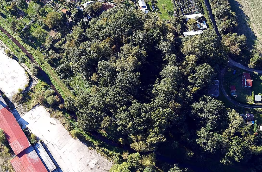
The fortress Talíř is an extinct medieval fortification on the edge of the lower terrace above the Bechyenské creek in Veselí nad Lužnice. The building has been protected as a cultural monument since 1973. It was probably created in the 14th century as a royal supporting point to protect the town and balance the Rožmberk influence in the region.
Due to the absence of archaeological research, the exact period of establishment of the fort cannot be determined with certainty. The first written mention of Veselí nad Lužnicí dates from 1 June 1259, when the village appears in the gift list of Voka z Rožmberk. At that time, however, the seat was not yet built. Its construction is supposed to be related to the reign of Charles IV, who sought to strengthen royal property. The existence of the building in the 14th century is evidenced by the findings of ceramic shards from surface collections.
The building design of the fortress is not exactly known due to the missing remains of the building. The building stood on an elevated hill with a rounded trapezoidal floor plan of 30 metres and a width of 13 to 18 metres. On three sides it was protected by a parabolic ditch 13 to 18 metres wide and about 2.5 metres deep. On the south side of the terrain naturally falls towards the Bechynia stream. The absence of trace evidence on the hill surface indicates that the site did not have a residential function and served exclusively as a military point.
The sources show that since the late 1960s the Merry King Václav IV. owned On July 21, 1378, the town stopped along with the fort, and I will sail to the Elder of Intermosti. The first written mention of the fortress itself appears in this document. Before April 1388 the Jindřich z Rožmberka Object was acquired and in January 1390 it was stopped by Václav IV. Wilhelm from Landstein. At the turn of the 14th and 15th centuries Veselí returned to the possession of the Rožmberks, but they did not invest further in the maintenance of the mansion. The last mention of the Vesel purcrabs dates back to 1412, then the fort disappeared.
The archaeological research of Daniel Kovář from 1993 to 2014 brought over 400 ceramic shards. However, most of the findings come from the period from the 16th to the 18th century, suggesting a possible secondary use of the site after the disappearance of the medieval building. In 2013, the town of Veselí nad Lužnicí carried out a pruning of an overgrown fortress, prevented the landfill of waste in the ditch and the site was fitted with an informative board.
The Talíř Chateau is an important piece of medieval effort to consolidate royal power in southern Bohemia. Visiting the site offers the possibility to look at the history of fortified settlements, which, despite their demise, tell us about the strategic importance of Veselí nad Lužnice in Luxembourg.
Historical milestones
- 1378
- First written mention of the fort in the pledge letter of King Wenceslas IV.
- 1412
- The demise of the maintenance of the fort by the Rožmberks.
- 1973
- The site statement for cultural heritage.
- 2013
- Modification of the city fort and installation of the information board.
Architectural development
The fort was situated on a hill with a trapezoidal platform, protected from three sides by a parabolic moat. In the absence of an archaeological survey, the exact form of the installation is unknown. Surface collections of ceramics indicate active use in the 14th century and possible later modifications in the early modern era.
Historical events
1378: First written mention of the fort in the Wenceslas IV lien. 1412: The last mention of the Vesel purcrabes, then the fort dies. 2013: The city carried out a pruning site and installed an informative board.
Owners
Czech monarch (Karel IV., Václav IV.), Ješek starší z Mezimostí (from 1378), Jindřich z Rožmberka (from 1388), Vilém z Landštejna (from 1390), Rožmberková (from the turn of the 14th and 15th centuries).
Points of interest
- The fortress Talíř is an extinct medieval fortification, which has been protected as a cultural monument since 1973. - The building was probably created in the 14th century as a royal supporting point to protect the town and balance the influence of the family Rožmberk. - The fort stood on a high hill with a trapezoid plan and a ditch up to 18 metres wide protected from three sides. - Absence of evidence from the installation suggests that the site did not have a residential function and served exclusively as a military point. - The first written mention of the fort comes from the charter of 21 July 1378, when King Václav IV. stopped the town along with the fort of Ješek the Elder of Intermosti.
Guide
Show guide text
This text was created by artificial intelligence and has not been editorially reviewed. It may contain inaccuracies.
Welcome to one of the most interesting, even at first glance invisible places in the whole area of Vesel nad Lužnice. You are standing in a place that carries a deep secret and a silent memory of the long past glory. Perhaps now it seems to you that there is only a common, high hill standing in front of you, standing over the bank of the Bechynia creek. You might be wondering why you would be interested in this place if you don't see any tall walls, no stone towers, no beautiful gates. But please believe me, under your feet and around you is a story that was once absolutely vital to the fate of the whole region. What you're observing is the site of the former Talíř fort. Even though all the buildings are long gone, the country itself is still talking about power, the struggle and the political games that were going on here hundreds of years ago.
Let us return together to the fourteenth century, to a time when power in these countries was not addressed at the table, but through fixed points in the landscape. Imagine a world where every hill and ditch could mean the difference between safety and danger. Talíř was not just built as an ordinary residence for nobles. It was a strategic, royal support point. At that time, the royal power needed to have a firm hand in this area. Talíř was intended to protect a nearby town and, above all, to balance the effects that were extremely strong in the area at the time. The main rival of the royal power was the mighty family of the Rožmberks. Talíř was in this way a tool by which the king tried to maintain balance and ensure that one single family did not control everything around him. It was a symbol of the royal presence in the heart of this country.
Now pay attention to what you see right in front of you. Even though all the buildings are long gone, the very shape of the landscape tells us how this fortress was built. Notice the elevated hill. Its shape is not random. If you look at its outlines, you'll believe it has a specific, flattering plan. This was not the work of chance, but a deliberate plan of the then builders who wanted to use every piece of the country for defense. Around this high ground was once a deep moat that had enemies stop before they even reached the gates themselves. Even though the moat may be less obvious today and has merged with the surrounding nature, you still feel the strategic advantage this place offers. You are standing on the edge of the valley terrace, on a location that has been selected with the utmost care to control the surrounding flow and travel in this area.
If we look deeper into the old records, the faces of people who once made important decisions will begin to reveal themselves. The first written trail about this place dates back to 1378, when King Talíř himself mentioned the fortress Václav IV. in one of his important papers. Before him, people were probably connected to Carl IV, who laid the foundations for the stability of the entire empire and for building these power points. But history isn't just about kings. Other important figures, such as Ješek starší z Mezimostí, were present in these premises. And we must not forget those against whom the Talíř opposed - the powerful rulers of the Rožmberk family, such as Jindřich z Rožmberka. The whole area was like a giant chessboard, where the state's greatest power forces moved, and where every building like Talíř had its irreplaceable role.
But here we come to the greatest mystery of this place that you might be interested in. Why does this hard fort, this royal point, virtually exist today? Why are there no walled walls or stone foundations that would help us understand its size better? History only gives us bits of answers. We know that by 1412, the situation began to change. The Rožmberks stopped taking care of the place and the maintenance of the fort ended. Maybe it was destroyed by war, maybe time and people gradually dismantled it into building materials for their own needs. It left only this quiet hill, which was declared a cultural monument in 1973. It's fascinating how a place can be so important and at the same time so invisible to a distracted observer. It's like the spirit of the past that still stands here, but no one can touch it anymore.
Now, please, let the atmosphere of this place drift. Walk around this hill, feel the silence and imagine how the guards once stood here, how fates were decided and how the interests of kings and mighty nobles were met. Even if the buildings are gone, the spirit of history remains in every rock and every piece of earth. Thank you for stopping by the Talíř fort and for trying to understand her story. We wish you a beautiful journey further along the footsteps of history in this beautiful neighborhood.
Tips for visitors
The best time to visit is during spring or autumn months when vegetation retreats and the terrain remains of the fort are better visible. In summer there may be a place covered with lush greenery, which makes it difficult to examine the remains of masonry.
The location is available by foot from the town center Veselí nad Lužnicí. Check public transport in the current search engines.
We recommend fixed footwear in the field because you move in the river terrace area. Take the repellent and camera with you, the best light to capture the atmosphere of ruins is in the morning or in the late afternoon sun.
For photographers, the most interesting view from the Bechynski creek is towards the edge of the terrace where the remains of the historical building can be captured in the context of the surrounding nature.
In the surrounding area you can visit the town of Veselí nad Lužnice, walk along the river Lužezka or follow the flow of the Bechyňský creek. For families with children, the location is suitable as a goal of undemanding scientific walks associated with the story of the history of medieval forts.
Frequently asked questions
Can the monument be visited?
This is a ruin. Such sites are often freely accessible, but some can only be visited with a guide or are closed for safety reasons. We have not verified the current situation – take care and respect any restrictions.
Where is the monument?
Location: Veselí nad Lužnicí I, Jihočeský kraj. The map on this page shows the exact spot.
Why is the monument protected?
It is listed in the Central List of Cultural Monuments of the Czech Republic as a cultural monument (register no. 1000153356).
Businesses nearby
Do you run a restaurant, accommodation, shop, museum, rental, wellness or other visitor service near this monument? Show yourself directly to the people heading to it — this is how they will see you in the app and on the web:
Nearby
Město Veselí nad Lužnicí, řeka Lužnice, Bechyňský potok (Blatská strouha).
Accommodation nearby
Trips and activities nearby
Guided tours, tickets and activities nearby from GetYourGuide
Affiliate link: if you buy from the partner, we may receive a commission. The price for you does not change.
Search tours and activities →Themed route
1. Veselí nad Lužnice, city - Great place to start the trip. 2. river Lužezka, water flow - Walk along the shore offers a quiet atmosphere. 3. Bechynia stream (Blatské trouha), stream - The path leads along this stream towards the goal. 4. Talíř (fortress), landmark - The main destination of a trip worth visiting.
Seasonal recommendations
In the spring, this ruin wakes up with nature. The trees are beginning to bloom around the walls and the grass gets a fresh green color. The light is soft in this period and very pleasant for photography. We recommend you take several layers of clothing because the wounds can still be cold while the afternoon is already warm. The roads around the monument can be muddy because of the rain, so prepare for more durable shoes.
In the summer months there is most life and the sun illuminates every detail of the old stones. The thick leaves create a pleasant shade, but heat can also be tiring. Due to the increased number of visitors in the main summer season, it is best to arrive first thing in the morning to enjoy peace and avoid the greatest heat. Don't forget enough water and headgear, because in open space the sun can be very sharp.
Autumn brings around Talíř a magical and a bit sad atmosphere. Leaves turn colors into vàngo and red, which perfectly contrasts with grey stones of ruins. The morning fog can often appear here, which gives the place a mystery. It is necessary to carry a waterproof jacket and tight shoes because wet leaves and wet soil can be slippery. Because the days are shorter, plan a visit so you can see everything before dark.
Winter turns this memory into a quiet and desolate landscape. Without leaves, the ruins are better visible, but the overall impression is rather cold and rough. If snow falls, the view of the old wall is beautiful, but movement can be dangerous due to frost on the rocks. Prepare very warm clothes, gloves and a hat. During this period, daylight is very limited, so plan your trip for the brightest hours of the day.
Visualizations and artistic views


The visualisations are generated by artificial intelligence and serve as inspiration.
Photos from the area
Real photos taken near the monument


Zdroj a licence jsou uvedeny u každého snímku.
Tips from visitors
No tips yet. Be the first!
Log in and add your tip.
Sources and literature
Photos: Kralpilot / CC BY-SA 3.0 — Wikimedia Commons. The author and licence also appear when you hover over the image.
Faktickým podkladem tohoto textu byl článek na Wikipedii, jehož autory jsou přispěvatelé Wikipedie. Článek je dostupný pod licencí CC BY-SA 4.0.
Location on the map

Příběhy a pověsti
Legendy, pověsti a příběhy spjaté s touto památkou
Fotografie návštěvníků
Zatím žádné fotografie. Buďte první, kdo přidá fotografii z návštěvy!
Log in a přidejte svou fotografii nebo hodnoťte.
Za ověřenou návštěvu v aplikaci získáte víc bodů — poznáme podle GPS, že jste na místě.
Reviews and comments