



Tašovice Hillfort
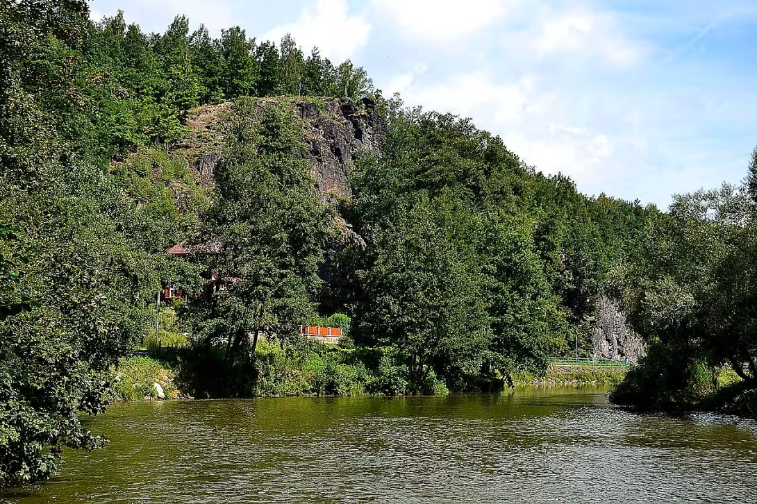
The Tašovické Hradiště, also known as Old Elk, is a significant archaeological site on a rocky island over the Ohří River near the village Tašovice in the Karlovy Vary district. The site is evidenced by prehistoric settlement and early medieval fortification and since 1964 it has been protected as a cultural monument.
The oldest phase of the settlement falls into the mesolite period, namely between 10,000 and 8,000 BC. Archaeological surveys have uncovered deep dwellings and a set of tools from materials from different parts of the Czech Republic and neighbouring regions. These findings suggest long-distance business contacts and the advanced structure of the company at the time. In the ninth century a Slavic castle was created in the same place, which probably guarded access to the Karlovy Vary basin. The site was located on a major trans-regional commercial road connecting the Czech inland to areas beyond the borders. In the tenth to twelfth century the settlement was replaced by a younger castle in Sedleca.
The building form of the castle consisted of an inner acropolis approximately 80 times 80 metres, separated by a moat and a wall from the forefront. The fortifications focused mainly on the north and west side, where the terrain follows straight. The other sides naturally protect steep slopes falling towards the Fire River. A chamber structure consisting of a front and inner stone wall, reinforced with wooden walls and filled with loose material, was used to build walls. The original height of these walls is estimated at up to four metres.
Systematic archaeological research began in 1911 Josef Knettl, which found charred stakes when exposed. In the first half of the twentieth century, the surveys of researchers A. Bergmana and H. Schrollera followed, on which A. Knor and F. Prošek were established between 1948 and 1950. Parts of the castle in the past damaged not only the mining of stone, but paradoxically the archaeological research itself. The younger farm fort, which took over the function of Tašovice estate, was later completely destroyed by the quarry activity.
Today the location is freely accessible to the public. Its remnants, namely the high wall of up to two metres, pass through the teaching trail of Doubi-Svatoše Rock. Visitors can observe the terrain remains of early medieval fortification. The site provides valuable evidence of the historical development of settlements in the Karlovy Vary region and offers the possibility of direct contact with the archaeological heritage of the region due to its accessibility.
Historical milestones
- 10000-8000 B.C. I.
- First phase of the settlement during the mesolite period.
- 9th Century
- The creation of Slavic castle with double wall.
- 1911
- First systematic archaeological unveiling.
- 1964
- Location registered as a cultural monument.
Architectural development
The fort was protected by a double wall with chamber structure, made up of a front and inner stone wall with wooden reinforcements and sprinkled fillings. The 80-by-80 meter acropolis was separated from the foothold by a moat and another wall. The original height of the fortifications was up to four metres, and today there are traces of wool.
Historical events
1911: First systematic archaeological unveiling of Josef Knettle. 1948-1950: Extensive archaeological survey led by A. Knor and F. Prošem. 1964: Announcement of the location by cultural monument.
Points of interest
- The fort is located on a rocky edge above the Ohří River and is also known under the name Old Loket. Since 1964, this place has been protected as a cultural monument. - The oldest settlement of the site comes from the mesolite period, namely from 10,000 to 8,000 BC. - In the ninth century, Slavic Hradic was established here, which probably guarded access to the Karlovy Vary Basin and lay at a major business trip. - The walls were built by chamber construction of stone walls and wooden walls filled with loose material, their original height being up to four metres. - Parts of the castle have been damaged in the past not only by mining stone, but also by archaeological research itself.
Guide
Show guide text
This text was created by artificial intelligence and has not been editorially reviewed. It may contain inaccuracies.
Welcome to this wonderful and fascinating place where time has stopped and where every rock and stone seem to have their own voice. You're standing on a rocky edge that rises high above the course of the Ohre River. Look around you and feel the incredible atmosphere. You see how the river beneath you flows smoothly through the landscape and its waters have shaped this rocky ridge for thousands of years. This rise, which people often call Old Elbow, is not just an ordinary piece of earth. It's a place where the power of nature collides with the incredible endurance of human life. Feel the cold wind and the sense of isolation that this edge offers. Because of this natural advantage, because of these steep rocks, this place has become a home for people in an incredibly distant past.
Let us now move together deep into dark times that most people cannot even imagine. This country has a much longer memory than it seems. The first traces of human presence are found here in a period we call mesolite. Ten thousand to eight thousand years ago, at a time when the world looked completely different from today, there was already a settlement. Imagine the hunters and gatherers who chose this rocky edge as their home. For them, the Ohře River was a key artery, bringing food and a path for business contacts. Even at a time when mankind was just beginning to know the world, there was movement of goods and ideas from very distant places. This site was already a strategic point that offered security and a view of the surrounding landscape.
Now, however, pay attention to another period, which has left much clearer traces of construction. If you look at the very form of this place, you can imagine in your mind how a solid Slavic wall stood here over one hundred years ago. In the ninth century, this site was built as an important castle. It was not just a random find, but a well-thought-out building designed to guard the entire access to the Karlovy Vary pelvis. You know, at the time, controlling these strategic points was absolutely crucial to the survival of the entire community. This Slavic fortification was known for its double wall, which created a double line of protection. Even though today we see only the rocky edge and natural shapes themselves, try to imagine the impenetrable barrier that once stood here protecting people from danger.
Looking at this rocky terrain, it's important to realize that what you see now is just a small part of what's hidden deep beneath your steps. However, in order to know what really happened here, we must turn to the work of the people who have decided to bring these secrets to light. The first systematic and scientific unveiling of this place began in the year one thousand nine hundred eleven. Since then, countless stories of search and discovery have taken place here. We must pay particular attention to these important personalities, which, with their patience and courage, have enabled us to understand the importance of Tašovice. Names like Josef Knettl, A. Bergman, H. Schroller, A. Knor or F. Prošek are very important in these contexts. That is what these people, using their tools and their scientific reasoning, were able to tell stories of ancient inhabitants from dust and earth. Thanks to their work, we now know that this place was not just an empty rock, but a living center of human existence.
Notice how unique this location is with its connection to nature. Since the year one thousand nine hundred sixty-four, this place has been protected as a cultural monument. This means that every stone that lies here has its weight and value. It's not just a pile of rocks, it's a rare record of human history. You might now think of a very interesting question: why this place? The answer lies in his position. The rocky edge over the Ohří River offers a combination of unavailability and great views. It's a place that forces you to stop and think about how the world was changing, while this edge remained the same.
There is one thing that could really interest you and leave you in awe. It's this incredible continuity. Imagine that incredible timeline. From the first people in the period of mesolite, to Slavic wall builders in the ninth century, to modern scientists here in the last century looking for answers. This site connects 10,000 years of human effort. It's like you're going through a book that has no beginning or ending, and you're in one of its most important chapters. The mystery that lies in these rocks is still alive. We never know what other layer of earth can reveal, what object or what evidence of ancient life will be hidden from our eyes.
I now ask you to continue this journey. Let yourself be drifted through the surrounding countryside, watch the flow of the river and perceive the strength of this rocky place. Take a look at the surrounding terrain and try to draw the ancient walls and the first settlers in your imagination. Tašovice and Old Elbow are not just archaeological sites, they are living testimonies of how we, as humans, have learned to live in accordance with this harsh but beautiful landscape. Thank you for choosing to make this journey with us. We wish you a pleasant further discovery and hope that this place will leave an unforgettable impression on you. We'll say goodbye, but you can carry the memory of this history all the way through your next walk.
Tips for visitors
The best time to visit is spring or autumn, when vegetation is thinner and the terrain on the rocky edge is better accessible. In summer the place can be overgrown and less accessible. The place is freely accessible, therefore we recommend fixed shoes for the field and suitable clothes for outdoor movement. For photographers, the location offers the best lighting conditions during the golden watch, when the sun lights up the rock run over the Ohří River. For families with children the trip is suitable as part of a longer walk, but due to the terrain is not accessible with a pram. In the nearby area you can visit the picturesque Svatoš rocks, walk along the river Ohře or go to nearby Karlovy Vary.
Frequently asked questions
Can the monument be visited?
This is an archaeological site. Often there is little to see on the ground and the land may be private. We have not verified access.
Where is the monument?
Location: Karlovy Vary, Karlovarský kraj. The map on this page shows the exact spot.
Why is the monument protected?
It is listed in the Central List of Cultural Monuments of the Czech Republic as a cultural monument (register no. 1000148422).
Businesses nearby
Do you run a restaurant, accommodation, shop, museum, rental, wellness or other visitor service near this monument? Show yourself directly to the people heading to it — this is how they will see you in the app and on the web:
Events nearby

Zdroj akcí: otevřená data měst a obcí ČR (Národní katalog otevřených dat) a kalendář akcí Národního památkového ústavu.
Nearby
Svatošské skály, řeka Ohře, obec Tašovice, město Karlovy Vary.
Accommodation nearby
Trips and activities nearby
Guided tours, tickets and activities nearby from GetYourGuide
Affiliate link: if you buy from the partner, we may receive a commission. The price for you does not change.
Search tours and activities →Themed route
1. City Karlovy Vary (City) - Start your journey in this familiar place. It's a great beginning for further discovery. 2. Svatos rocks (Natural formation) - This area offers beautiful views of rock walls. It's an ideal place for a short walk. 3. River Reel (Water flow) - During the journey you can follow this water unit. It's a key element of the whole landscape. 4.Tašovice (Archaeological site) - Here you will find the main destination of your journey. This area is important for understanding old history.
Seasonal recommendations
Spring: In the spring period, Tašovice, an archaeological site in Karlovy Vary, is transformed into a special place of exploration. The sun's rays illuminate the ruins and bring life to the blooming surroundings. Green tree leaves are exposed to light, creating a comfortable atmosphere for visitors. It is advisable to visit the memory in the semi-deck when the sun is the most distinctive and nature is in its full bloom. Put on comfortable shoes to walk on Earth's roads and you must not forget the protective cover, because the spring wind can be surprising.
Summer: Summer brings the highest attendance of Tašovice. Sunny days and warm night peace are the perfect time to explore archaeological remains when lighting is best. The wet air in the main summer season can be challenging, so we recommend arriving early in the morning or later in the day to avoid the crowd. Don't forget the sun cream and plenty of drinking water. Put on light clothes to keep your temperature under control.
Autumn: In autumn the Tašovice becomes melancholic with rich colour foliage. Sunshine days are still present, but the length of the day is gradually shortening. The atmosphere is quiet and suitable for a quiet walk between historical ruins. Humidity can be high, so we recommend bringing protective clothing against moisture. Beautiful leaf colors are best seen on the middle of the day when the sun is at its highest.
Winter: Winter Tašovice offers a unique view with covered snow ruins and quiet atmosphere. Sunshine days are shorter, but the sun can be very dazzling, which increases the attractiveness of the visit at noon. It is necessary to realize the short opening time of the monument and prepare for a cool temperature. Hot clothes, protective shoes and a cover head are essential for a comfortable visit. Winter calm is ideal for a quiet walk and use of a closed atmosphere of archaeological remains.
Visualizations and artistic views


The visualisations are generated by artificial intelligence and serve as inspiration.
Photos from the area
Real photos taken near the monument


Zdroj a licence jsou uvedeny u každého snímku.
Tips from visitors
No tips yet. Be the first!
Log in and add your tip.
Sources and literature
Photos: Petr Kinšt / CC BY-SA 4.0 — Wikimedia Commons. The author and licence also appear when you hover over the image.
Faktickým podkladem tohoto textu byl článek na Wikipedii, jehož autory jsou přispěvatelé Wikipedie. Článek je dostupný pod licencí CC BY-SA 4.0.
Location on the map
More monuments – Karlovy Vary
Show all in the municipality
Příběhy a pověsti
Legendy, pověsti a příběhy spjaté s touto památkou
Fotografie návštěvníků
Zatím žádné fotografie. Buďte první, kdo přidá fotografii z návštěvy!
Log in a přidejte svou fotografii nebo hodnoťte.
Za ověřenou návštěvu v aplikaci získáte víc bodů — poznáme podle GPS, že jste na místě.
Reviews and comments