



Území bojiště u Přestanova, Chlumce a Varvažova Landscape heritage zone
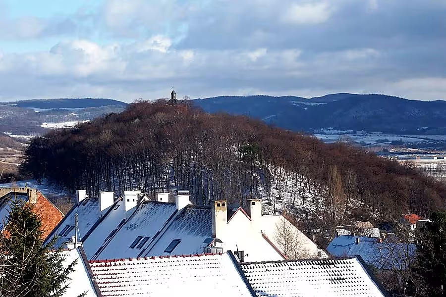
Území bojiště u Přestanova, Chlumce a Varvažova is a landscape monument zone of 749 hectares. It is located in the Chabarovická pány in the district of Ústí nad Labem and Teplice. This site is of great historical importance, as there has been a key military conflict of European reach for centuries. Since 1996 the area has been protected as a historical landscape of extraordinary value.
Historic sources show settlement in the early Middle Ages. According to information from the 13th century, there was already a prince's guard fort with customs in 993. The object protected the way through the Nailer Pass to the Myssa. For centuries, the location has been a strategic point for defending the Czech state against northern invasions. The road near Chlumce was divided into branches leading to the Czech interior.
From a geomorphological point of view of the territory it belongs to the Chabarovic Basin, which is part of the Mostecký Basin. The northernmost edges extend to the foot of the Nakléřov Mountains. The landscape is mostly agricultural, although its form in the second half of the 20th century affected the development of Chlumka and later satellite construction near Stradov. A significant natural dominant feature is the subvulcanic body of the mountain top. From 1685 to 1691 the chapel of the Holy Trinity grew on it. It was built by the owner of the Puppet Manor Jan František Krakovský z Kolovrat to thank you for protecting the region from the plague epidemic.
In 1040 Prince Břetislav I. prevented the German king Henry III from invading the Czech Republic. Another significant clash took place on 18 February 1126, when the Czech army of Prince Soběslav I. defeated the army of Roman King Lothar III, which strengthened the power of the Přemyslívov. On 16 June 1426 Hussites at Chabarovice defeated a numerically stronger army of Reich-German mercenaries. The area was also affected during the 30-year war when almost all the settlements around Chlumka were depopulated.
The biggest military conflict of European importance in this area was the Battle of Chlumce on 29 and 30 August 1813. The French forces of Naples met with the Allied armies of Russia, Prussia and Austria. After the initial success of the French, the situation turned the other day and the battle ended with their escape. The tragic consequences included the destruction of Hlumek, Stradov, Žandov, Stástanov, Routní a Dolní Varvájov. Some 9,300 Allied and 11 000 French soldiers have lost their lives.
The object of protection is the entire battlefield with dozens of war monuments and mass graves. The Prussian memorial at Varvajov was revealed in 1817, followed by the Austrian memorial at General Colloredo-Mansfeld in 1825 and the Russian memorial at Přestán, whose base stone was laid in 1835. In the same year, remains of the fallen were placed in a mass grave near the Russian memorial. Other important objects are the 1911 French memorial and the 1913 Jubilee memorial. The remains of the soldiers are also stored in a mass grave in a cemetery in Chlumci.
Today, this area is accessible as a landscape monument zone. It offers insight into the history of military conflicts that directly influenced the power position of Czech rulers. Visiting the site allows you to understand the strategic importance of the subcircling mountain area and to honor the memory of the fallen at many preserved pietas.
Historical milestones
- 993
- First mention of the prince's guard's castle on the mountain top.
- 1126
- The victory of the Czech Prince Svozslav I over the Roman king Lothar III.
- 1813
- An extensive battle in Chlumka between French and Allied forces.
- 1996
- Announcement of the territory by the landscape monument zone.
Historical events
The Battle of Chlumce in 1126, the Battle of Chabarov in 1426 and the Napoleonic Battle of Chlumce in 1813.
Points of interest
- The territory of the battlefield is a landscape monument zone of seven hundred forty-nine hectares, which since nineteen hundred ninety-six has been protected as a historical landscape of extraordinary value. - In the year nine hundred and ninety-three princely guard forts with customs, which protected the way through the pass to Míně. - The chapel of the Holy Trinity on top of the Horka had in the years sixteen hundred and eighty-five to sixteen-ninety-one built the owner of the estate Jan František Krakovský z Kolovrat as a thank you for protecting the region from the plague. At the Battle of Chlumce in August, eighteen hundred thirteen died approximately nine thousand three hundred Allied and eleven thousand French soldiers. - The object of protection is the entire battlefield, where there are dozens of war monuments and mass graves of fallen soldiers.
Guide
Show guide text
This text was created by artificial intelligence and has not been editorially reviewed. It may contain inaccuracies.
Welcome to the heart of the Chabarovice Basin. Stop for a moment, take a breath and look around you. You're standing in the middle of a vast landscape that can at first glance seem calm and normal. In front of you you can see open spaces, wide agricultural areas and in the distance the dominant peak of Horka, which is victorious over the surrounding area. You may only perceive the wind in the fields and the silence of the countryside, but this country beneath your feet carries deep layers of history. What you see is not only a landscape, but a huge open archive, in which the fate of thousands of people and power surges throughout Central European countries are written.
This area, which we now know as the territory of the battlefield at Přestán, Chlumce and Varvajov, is declared a landscape monument zone. It's a place where over the centuries, armies have met, borders have been decided, and the history of our ancestors has been written. This zone has been officially protected since nineteen hundred ninety-six, because its value is not in buildings or statues, but in the very layout of the terrain and in the memory it keeps. It is a historic landscape of extraordinary value that allows us to perceive space today as it was perceived by soldiers and commanders hundreds of years ago.
Now, when you look around, pay attention to exactly how the landscape is made. Notice the slight hills and deepening Chabarovice pelvis. It was this terrain that was crucial in the past. The strategic location of the hills and valleys determined where the troops followed and where they stopped to fight. Look towards the top of the heat. This point has been the most important landmark for centuries. Already in the year nine hundred and ninety-three there stood the Prince's guard castle, which served as an important watchpoint. Imagine there was a customs office here at the time that controlled the road and protected the region. It was a place of power and control where passengers and traders from different corners of the country met.
Now let's move on in time and try to imagine what happened here. This country witnessed dramatic clashes. One of the most important was the year one thousand twenty-six. Imagine the tension that prevailed in this space when Czech Prince Sobeloslav first led his troops against the Roman king Lothar the third. It was a clash of two powerful personalities and two different ambitions. Soběslav first proved his military prowess here and won a victory which at that time was of great importance for the position of the Czech princes within the empire. When you walk on these fields today, think of the sound of armour, the tearing of horses, and the rumbling of a battle that once drowned the silence of this pelvis.
However, this landscape is also linked to other important figures. For example, we remember Břítislav the first, whose tracks we are moving in the early history of this place, or Jan František Krakovský of Kolovrat, who left his trail in the later history of this region. Each of them perceived this space differently, but all recognised its strategic value.
If we move forward in time, we get to 18,000. That was the time when this landscape turned into a bloody battlefield again. There was an extensive battle at Chlumce, where powerful French troops met with allies. Introduce yourself as a soldier who stood in the same place as you at the time. You would see endless rows of troops, you would hear the rumbling of cannons, and you would see the smoke that covered the horizon of the Chabarovice Basin. This battle was not only a local conflict, but a part of the great European faith that changed the map of the entire continent. That is why today this territory is protected as a monument. It's not about the walls standing here, it's about the space where these events took place.
Now I want to impress you with one interesting thing, which may not be visible at first sight. The whole landscape monument zone is situated on an area of seven hundred forty-nine hectares. It's a huge space that's protected as a whole. It is fascinating to think that such a vast area of agricultural land is also a historic monument. The mystery remains many details of the old clashes that are no longer written in the books, but remained buried in the dirt. Who knows how many forgotten objects or traces of ancient troops are still resting beneath the surface of these fields? It is this invisible layer of history that gives the place a special atmosphere.
Now, when you look around, feel the contrast between today's room and the stormy past. Notice how the agricultural landscape harmoniously intersects with historical points such as the top of the heat. It is a reminder that history is not only in museums or books, but is present in the very country we walk on.
Thank you for joining me on this short journey in time. This landscape still has something to tell if we can only listen to the silence of the fields and observe the line of the horizon. I ask you to continue your walk now, try to map the places where the key moments of the battle at Chlumka took place, and look again at the top of the heat from a different angle. Let your imagination guide you and perceive the spirit of this unique place. I wish you a pleasant rest of your discovery of this fascinating historical landscape. Goodbye.
Tips for visitors
The best time to visit is the spring or autumn period when the landscape is clear and the sun is located below the horizon, creating beautiful shadows on the wavy terrain of the battlefield. Use your own car or public transport for transport, find the connection in the current timetables. Take with you fixed shoes suitable for field movement and binoculars to observe details in the landscape. It is ideal for shooting the top of Horka, where it is wide view of the whole area, the best light for images is obtained during the golden watch shortly after sunrise or before sunset. In the surroundings you can visit the town of Chlumec, the village of Varvajov, Prestanov or go for a walk in the town of Klířovská Hornatina, which is also suitable for families with children who appreciate the nature movement associated with the recognition of history in the field.
Frequently asked questions
Can the monument be visited?
This is a structure in a public space that can usually be seen from outside free of charge. We have not verified that this particular one is freely accessible.
Why is the monument protected?
It is listed in the Central List of Cultural Monuments of the Czech Republic as a cultural monument (register no. 1000084342).
Businesses nearby
Do you run a restaurant, accommodation, shop, museum, rental, wellness or other visitor service near this monument? Show yourself directly to the people heading to it — this is how they will see you in the app and on the web:
Nearby
Nakléřovská hornatina, město Chlumec, vrch Horka, obec Varvažov a Přestanov.
Accommodation nearby
Trips and activities nearby
Guided tours, tickets and activities nearby from GetYourGuide
Affiliate link: if you buy from the partner, we may receive a commission. The price for you does not change.
Search tours and activities →Themed route
Thematic cruise route: Území bojiště u Přestanova, Chlumce a Varvažova
1. The territory of the battlefield near Prestana - Historical site, monument This territory is a key place to understand the history of the region during war conflicts. Visit and enjoy the educational exhibition that brings a view of history and the strategic significance of this place.
2. City Hlumec - Historical Center About 10 km from the battlefield is the town of Chlumec, known for its history and architectural monuments. Explore ancient streets and enjoy the culture and tradition of the region.
3. Top Hot - Horizontal View On the way from Chlumce to Varvajov, the mountain hill will appear, offering beautiful views of the surrounding countryside. This place is ideal for relaxing and exploring the natural environment of the region.
4. The village of Varvajov - Culture and Tradition The village of Varvajov, known for its history and cultural heritage, is approximately 5 km from the mountain. Visit the local sights and discover life in the traditional Czech village.
5. Stop - Historical residence At the end of the route you can explore the historical building and enjoy the quiet surroundings. This place completes the journey through the regional heritage and offers the possibility of relaxation.
This route will guide you through a region rich in history and natural beauty, allowing you to understand the region more deeply.
Seasonal recommendations
In spring, the landscape around the battlefield awakens into life. Blossoming meadows and fresh greenery give the place hope that contrasts with its war history. I recommend visiting the sights in the morning when the light is fine and the air is clean. Due to spring rains, choose waterproof shoes and light, laminated clothes.
The summer season brings a radiant sun and dense vegetation that surrounds memorable points. The atmosphere is hot and peaceful, ideal for long walks in nature. The best time to visit is early morning or late afternoon so you don't get hit by the hottest hot season. Don't forget the hat, enough water and light summer clothes.
Autumn is the most atmospheric for these places. Color leaves and frequent fog create a melancholy mood that matches the nature of the battlefield. The low sun highlights the relief of the terrain and the details of the monuments. It is practical to choose fixed shoes into wet grass terrain and warm sweater or windbreaker.
In winter there is silence and rigor of the landscape under a layer of snow. The fallen trees reveal views that are hidden in other seasons, and the white landscape seems very clean and humble. For short days, go out in the light of day. Hot layers of clothing, gloves and quality winter shoes are essential.
Visualizations and artistic views

The visualisations are generated by artificial intelligence and serve as inspiration.
Photos from the area
Real photos taken near the monument


Zdroj a licence jsou uvedeny u každého snímku.
Tips from visitors
No tips yet. Be the first!
Log in and add your tip.
Sources and literature
Photos: ftom / Public domain — Wikimedia Commons. The author and licence also appear when you hover over the image.
Faktickým podkladem tohoto textu byl článek na Wikipedii, jehož autory jsou přispěvatelé Wikipedie. Článek je dostupný pod licencí CC BY-SA 4.0.
Location on the map
More monuments – Ústecký kraj
Show all in the region

Příběhy a pověsti
Legendy, pověsti a příběhy spjaté s touto památkou

Fotografie návštěvníků
Zatím žádné fotografie. Buďte první, kdo přidá fotografii z návštěvy!
Log in a přidejte svou fotografii nebo hodnoťte.
Za ověřenou návštěvu v aplikaci získáte víc bodů — poznáme podle GPS, že jste na místě.
Reviews and comments