






Na Valech (Horní Přím) Hillfort
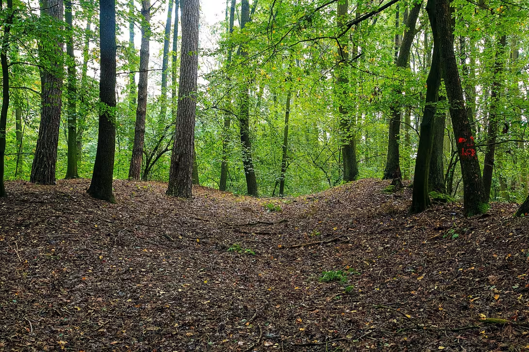
Na Valech (Horní Přím) is located an archaeological site south of the village of Horní Pří in the district of Hradec Králové, on the edge of the Trímské forest. This object is located near the village Dolní Přím and represents the remains of an undated fortification which is protected as a cultural monument.
There is little documented information about the creation and precise age of this place, and expert opinions differ on this issue. It is assumed that it could be an ancient or early medieval fortress. August Sedláček considered the remains to be a medieval fortress, while Josef Ladislav Píč thought it was an early modern military camp from the time of the Thirty Years War.
The site measures approximately 150 × 180 metres. The fortification was preserved mainly on the north-east to south-east side in the form of a pair of parallel boulders about 90 metres long. The outer wall reaches a height of up to 3.5 metres, while the inner wall has a maximum of 2 metres. In the west to the west, there is a short wall of approximately 30 metres in length. The south to southwest side of the fortification is not visible. The only defense here is a slight slope with a height of 1 to 1.5 metres, while part of the terrain is soaked in this area.
The original scope of the fortification was significantly larger than that seen today, since the north-west to north part was completely destroyed by the new sand and gravel pit. The archaeologist L. Domeček reported that there was a three-way wall on the northeast and southeast side with a double moat. In relation to the findings of the graves, he also mentioned a medium wall which was also destroyed by progressive mining.
Today there are mainly traces of wool on the northeast and southeast sides. The archaeological site offers a view of fragments of history that survived mining in the surrounding landscape. The site is worth visiting so that interested people can see the preserved elements of the fortifications near the Trámské Forest.
Historical milestones
- Around prehistoric to early Middle Ages
- Possible formation of an ancient or early medieval castle.
- Media
- The existence of a medieval fortress according to expert estimates.
- 1618-1648
- Possible use as a military camp during the Thirty Years' War.
- 20th century
- Partial destruction of fortification by mining in sand and gravel.
Architectural development
The fortification consisted of a pair of parallel bays with an external height of up to 3,5 metres. Archaeological records also suggest the existence of a triple wall with a double moat, but it was destroyed by mining.
Points of interest
- The site represents the remains of an undated fortification and is protected as a cultural monument. - His old age is different from the primordial castle to the military camp from the time of the Thirty Years War. - The area is approximately 150 × 180 metres and is located on the edge of the Trámské forest. - The fortification on the north-east and south-east side consists of a pair of parallel boulders with an external height of up to 3.5 metres. - The northwest to north part of the original fortification was completely destroyed by a new sand and gravel pit.
Guide
Show guide text
This text was created by artificial intelligence and has not been editorially reviewed. It may contain inaccuracies.
Welcome to the archaeological site on the Valech. Right now, when you're standing on the edge of the Direct Forest in Lower Primes, you're in a place that at first glance can act as a simple piece of the natural landscape. You may see only mild terrain inequalities, trees and endless green surroundings. However, please pay attention to what is under your feet and in the very structure of this country. What you see is not the work of chance, but the remains of something that once had great meaning to protect, defend, and endure. You're standing in front of a castle whose exact secret is still hidden from human sight.
Now let's try together to understand what this place means and how different layers of time intersect here. This area, spread out on an area of approximately 150 meters over 100 meters, is a fascinating puzzle for anyone interested in our roots. The history of this place is not clearly written in the books, but rather carved into the soil itself, which only in turn reveals its truths to us. Where did these times come from? The answer to this question is the subject of constant expert debates. Some researchers believe there is an ancient ancient castle, a place where the first people sought safety in the arms of the forest. Others, in turn, suggest that it is a medieval fortress, a fixed place that ruled the surrounding territory. There are other theories that lead us to a period of 30 years of war. Perhaps these places were used as military camps when the landscape trembled in the foundations of conflicts that changed the face of the whole of Europe. Each of these possibilities gives this place a different feel, a different weight and a different depth.
Now pay attention to what you can see right around you. Although this monument is partially disturbed, its original face is still visible. If you look around, you can see the remnants of the waves that were once parallel and formed a solid defense of this compound. Note above all what remains on the northeast and southeast side. This is where the remains of the fortifications are the most significant. But you have to realize that what you see is just a fraction of the original whole. This historical trail has been inexorably disrupted in the past by human activity. In the twentieth century there was extraction of sand and gravel, which led to the irreversible destruction of some of the original fortifications. This modern sandbox, which was once here, has revealed some parts of history, but at the same time it has taken away much that could help us to understand this place in all its beauty and complexity.
Looking at these ground structures, you can imagine the efforts of the people who had to make them. Even if we don't know the names of the architects who designed these times, we can feel their intention. They wanted to create a barrier to separate the inner safe space from the unknown outside world. This land work, the material offered to them by the forest and the surrounding terrain, was the basis of their existence.
But in order to better touch on the real life that took place here, we need to look at the people who took care of this place in the New Testament. Even though the builders themselves remained unknown in history, thanks to the work of experts such as August Sedláček, Josef Ladislav Píč or L. Domeček, we can know much more about this place than if we rely on our own eyes. These people, as detectives, were trying to make a story out of little things, fragments and landscape shapes that he was trying to tell. Their efforts allowed us to see this place not only as a pile of clay, but as a protected cultural monument that deserves our respect and attention.
And it is here that the greatest mystery that may follow you all along this site. What is this place anyway? Is it an ancient fortress that has survived for thousands of years? Is it a medieval fortress that was later abandoned? Or is it just a short-term military post that was born here and destroyed during the devastating wars of the seventeenth century? But this uncertainty is what makes Na Valech so special. It's not just a place with a clear, solved story. It's a place that makes us think, that makes us ask questions, that reminds us how little we know about the past that shaped us. This ambiguity is part of his spell. Every layer of the earth, every impact of wind current through these remnants of the waves, can give us a different sense of how people once lived, fought or rested here.
Now I want to invite you to continue your tour and let the atmosphere of this place drift. Take a walk along those visible waves, try to visualize their original height and strength in spirit. Feel the silence of the Direct Forest and imagine what sounds could have sounded like hundreds or thousands of years ago. Be patient in your observation. Sometimes it only takes one look at a different angle to develop a new connection before your eyes. Thank you for choosing to visit this important place and devote your time to understanding its secrets. We will deny you once again that you are in a protected area, so please move with respect to nature and these historical tracks. We wish you a pleasant continuation of the survey and hope that this place will enchant you as it did us. Goodbye.
Tips for visitors
For the best experience we recommend a visit during spring or autumn. In these times, vegetation is less dense, which allows for better visibility of structures of unknown fortification and historical fleas.
Transportation to the place is possible by car and public transport. Please check the current information about connections and parking possibilities in the relevant traffic search engines before travelling.
Since you are located on the edge of the forest and it is an archaeological site, we recommend to take with you comfortable shoes to move in uneven terrain, enough drinking water and insect repellent.
Photographs are the most suitable moments during sunrise or sunset. Low light creates interesting shadows that highlight the shapes and dimensions of the complex.
In the vicinity you can explore A direct forest or visit the nearby villages of Upper Pří and Dolní Přím. For families with children, the place is suitable for a free walk in nature, but requires increased attention due to terrain inequalities.
Businesses nearby
Do you run a restaurant, accommodation, shop, museum, rental, wellness or other visitor service near this monument? Show yourself directly to the people heading to it — this is how they will see you in the app and on the web:
Events nearby

Zdroj akcí: otevřená data měst a obcí ČR (Národní katalog otevřených dat) a kalendář akcí Národního památkového ústavu.
Nearby
The direct forest, the village of Upper Pří and Dolní Přím.
Accommodation nearby
Themed route
Na Valech (Horní Přím) Type: Archaeological site The main objective of this cruise route is a unique place where the traces of human settlement from prehistoric times are preserved. Visitors can imagine the life of our ancestors in a natural environment that has at least changed in this area.
Direct les Type: Natural services Forestry is an ideal background for understanding the context of archaeological sites. The walk here offers a peaceful atmosphere and the possibility to observe the local flora and fauna that inhabited this landscape for centuries.
Upper Direct Type: Village This village is directly linked to the history of the site and serves as a starting point for a deeper study of the region. Here you can find a quiet environment suitable to reflect on the historical heritage of the place.
Dolní Přím Type: Village The location where the entry point to this thematic route is located. The village provides a basic infrastructure for visitors and allows a smooth transition between the various points of interest in the surroundings.
The route is designed in such a way as to respect the limited range of information available and to focus exclusively on the places mentioned. It starts in the village Dolní Přím, from where visitors will head towards the archaeological site Na Valech in Upper Direct. After the tour of the main destination it is possible to continue by walking through the direct forest, which connects both parts of the village and offers views of the landscape. The entire circle is short and suitable for families and individuals who seek to connect with history and nature without the need to visit more distant monuments. Emphasis is placed on an authentic experience from where history touches the present.
Seasonal recommendations
Spring: There is a special atmosphere of calm and restoration at the Valy in the spring, where newly growing shrubs and flowers bring a colorful palette to the region. Sun rays illuminate ruins in a special way, which may be the perfect time for photography. Visitors should wear a warm coat because they can still be cold in the morning and evening. The best thing is to come at noon, when the sun warms up and drives out the clouds, allowing you to fully explore the historic place without fear of uncomfortable weather.
Summer: In summer Na Valech is most visited when sunny days and warm air attract many visitors. Nature is in full bloom, which gives the area a colorful life and a calm atmosphere. To manage large crowds it is recommended to arrive early morning or late afternoon. Equipment with short but warm clothes and sun protection is crucial for enjoying this historic place without discomfort.
Autumn: Autumn on Na Valech offers a mysterious atmosphere where the color of the leaves changes and trees create a living picture. The sun illuminates the ruins of the afternoon with long rays, adding a romantic touch in this historic place. Visitors should be prepared for colder weather and likely rainy season, because it is suitable to dress with waterproof elements. The best time to visit is in the afternoon when the temperature is pleasant and the atmosphere is calm.
Winter: Winter in Na Valech offers quiet moments without large crowds. The atmosphere is quiet and the room seems to be lonely, allowing for more intense reflection on the history of the place. The sun rays beyond the horizon can illuminate ruins with breathtaking colors. Visitors should be well prepared for cold, with warm clothes and wind protection. Winter visits are ideal in the morning or in the evening when it is quieter and fewer people, which allows you to immerse yourself more fully in the atmosphere of this historic place.
Visualizations and artistic views

The visualisations are generated by artificial intelligence and serve as inspiration.
Photos from the area
Real photos taken near the monument


Zdroj a licence jsou uvedeny u každého snímku.
Tips from visitors
No tips yet. Be the first!
Log in and add your tip.
Sources and literature
Fotografie: Petr1888 / CC BY-SA 4.0 — Wikimedia Commons. The author and licence also appear when you hover over the image.
Faktickým podkladem tohoto textu byl článek na Wikipedii, jehož autory jsou přispěvatelé Wikipedie. Článek je dostupný pod licencí CC BY-SA 4.0.
Location on the map
More monuments – Dolní Přím
Show all in the municipality
Příběhy a pověsti
Legendy, pověsti a příběhy spjaté s touto památkou

Fotografie návštěvníků
Zatím žádné fotografie. Buďte první, kdo přidá fotografii z návštěvy!
Přihlaste se a přidejte svou fotografii nebo hodnoťte.
Za ověřenou návštěvu v aplikaci získáte víc bodů — poznáme podle GPS, že jste na místě.
Reviews and comments