




Plastická geologická mapa Sculpture
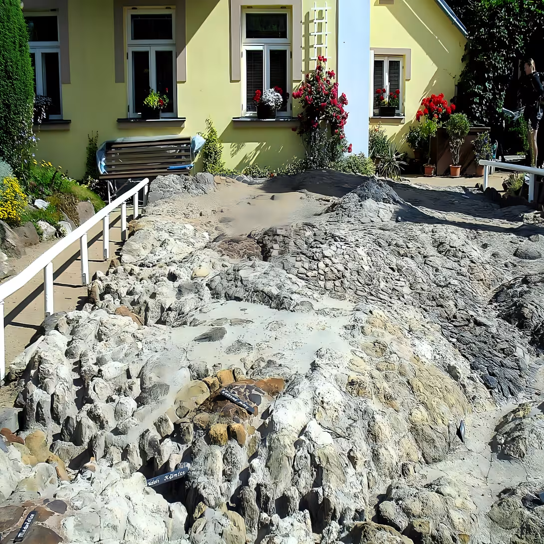
The Plastická geologická mapa, a unique cultural monument, is located in the Šluknovský výběžek region. Rudolf Kögler created this relief geological map between 1931 and 1935 using rocks from various localities to represent a miniature copy of the terrain between Mandava, Panský, Vlčí hora, Brtníky, Kyjov, Doubice, and Krásný Buk. The map showcases Rudolf Kögler's passion for geology and his desire to share his knowledge with the public.
The monument's origin dates back to 1931 when Rudolf Kögler began creating the geological map. Over four years, he worked tirelessly to complete the project, using rocks from various localities to create a miniature copy of the terrain. The map was finally opened to the public in 1937.
The Plastická geologická mapa is a relief geological model created by Rudolf Kögler using rocks from various localities. It represents a miniature copy of the terrain between Mandava, Panský, Vlčí hora, Brtníky, Kyjov, Doubice, and Krásný Buk.
The monument has seen its share of interesting events over the years. In 1941, Rudolf Kögler opened an educational trail that ran along the lužický zlom, featuring seven dozen information boards. Although the trail was not reopened after World War II, it was revived in 2006 as part of the new Köglerovy naučné stezky Krásnolipskem.
Today, the Plastická geologická mapa is a popular tourist destination and cultural monument. Visitors can access the map during the summer months from May 15th to September 30th, Monday to Thursday from 8 am to 5 pm. The monument is closed on Fridays and Saturdays.
The Plastická geologická mapa is an important piece of Czech history and culture. It offers a unique glimpse into the region's geological past and serves as a testament to Rudolf Kögler's passion for geology. Visitors are invited to explore this fascinating monument and learn more about its rich history and cultural significance.
Historical milestones
- 1931
- Rudolf Kögler begins creating the geological map.
- 1935
- Kögler completes the project using rocks from various localities.
- 1937
- The Plastická geologická mapa is opened to the public.
- 1941
- Rudolf Kögler opens an educational trail along the lužický zlom with seven dozen information boards.
- 2006
- The educational trail is revived as part of the new Köglerovy naučné stezky Krásnolipskem.
Architectural development
The map is a relief geological model created by Rudolf Kögler using rocks from various localities. It represents a miniature copy of the terrain between Mandava, Panský, Vlčí hora, Brtníky, Kyjov, Doubice, and Krásný Buk.
Historical events
1931-1935: Creation of the geological map by Rudolf Kögler
1937: The map was opened to the public
2006: The original trail was reopened as part of the new Köglerovy naučné stezky Krásnolipskem
Owners
Rudolf Kögler
Anna Köglerova
Köglerova vnučka
Points of interest
– The Plastická geologická mapa is a unique cultural monument located in the Šluknovský výběžek region.
– Rudolf Kögler created this relief geological map between 1931 and 1935 using rocks from various localities to represent a miniature copy of the terrain between Mandava, Panský, Vlčí hora, Brtníky, Kyjov, Doubice, and Krásný Buk.
– The monument has seen its share of interesting events over the years, including the opening of an educational trail in 1941 featuring seven dozen information boards.
– Today, the Plastická geologická mapa is a popular tourist destination and cultural monument that offers a unique glimpse into the region's geological past.
Guide
Show guide text
This text was created by artificial intelligence and has not been editorially reviewed. It may contain inaccuracies.
Welcome to this incredible historical monument! As you stand before it, take a moment to absorb the sheer scale and beauty of the Plastická geologická mapa, a unique cultural treasure located in the Šluknovský výběžek region.
As you gaze upon this remarkable relief geological map, you might wonder how it came to be. Well, let me tell you - Rudolf Kögler, a visionary artist and geologist, spent four years between 1931 and 1935 creating this masterpiece using rocks from various localities. The result is a miniature copy of the terrain between Mandava, Panský, Vlčí hora, Brtníky, Kyjov, Doubice, and Krásný Buk.
As you take in the intricate details of the map, notice how it's not just a visual representation but also an educational tool. Kögler's creation is meant to be explored and learned from, which is why he went on to open an educational trail along the lužický zlom with seven dozen information boards in 1941.
But what makes this monument truly special are the people behind it. Rudolf Kögler was a true pioneer, and his legacy lives on through his family, including his wife Anna and their granddaughter. Their stories are woven into the fabric of this place, making it all the more meaningful to visit.
As you continue to explore this incredible monument, keep an eye out for some of its lesser-known features. Did you know that in 2006, the educational trail was revived as part of the new Köglerovy naučné stezky Krásnolipskem? It's a testament to the enduring power of Kögler's vision.
As you stand before this remarkable monument, I invite you to take your time and truly absorb its beauty. Let the stories of Rudolf Kögler and his family come alive for you, and let the educational trail guide you through the wonders of geology and history. There's so much more to discover here - take a step back, look around, and see what secrets this incredible monument has in store for you.
Tips for visitors
Best Time to Visit: The Plastická geologická mapa is a year-round attraction, but the best time to visit is during spring or autumn when the weather is mild and sunny. This allows for optimal photography conditions and comfortable exploration of the monument's surroundings.
Businesses nearby
Do you run a restaurant, accommodation, shop, museum, rental, wellness or other visitor service near this monument? Show yourself directly to the people heading to it — this is how they will see you in the app and on the web:
Nearby
The monument is located in a quiet neighborhood, approximately 100 meters north of the tourist information center near the railway crossing.
Accommodation nearby
Themed route
Tour Route
1. Plastická geologická mapa (skulptura) - The main attraction, a unique plastic geological map sculpture that stands out for its innovative design and educational value. 2. Železniční přejezd - A quiet neighborhood railway crossing with a charming atmosphere, offering a glimpse into local life and a chance to observe the surrounding area. 3. Tourist Information Center - A convenient stopover point where you can gather information about the area, ask for recommendations, or simply take a break from your tour.
This route takes you through the heart of Zahrady's neighborhood, showcasing its unique features and charm.
Seasonal recommendations
Spring brings a sense of renewal to the Zahrady, where the awakening flora and soft, diffused light create a serene backdrop for the Plastická geologická mapa. It is an ideal time to appreciate the delicate balance between nature and art. Visitors should wear layered clothing to account for fluctuating temperatures and consider visiting on weekdays to avoid the initial surge of seasonal tourists.
During the peak summer season, the gardens are in full bloom, providing a lush, vibrant environment. The high sun casts sharp shadows that emphasize the three-dimensional details of the Plastická geologická mapa. To avoid the midday heat and the largest crowds, it is recommended to arrive early in the morning. Lightweight, breathable fabrics and sun protection are essential for a comfortable experience.
Autumn transforms the Zahrady into a palette of gold and crimson, offering a melancholic yet beautiful atmosphere. The crisp air and lower angle of the sun enhance the textures of the Plastická geologická mapa, making it a favorite time for photography. Sturdy footwear is advised for walking through fallen leaves, and a warm jacket is necessary as the evening chill sets in quickly.
Winter brings a quiet, minimalist beauty to the site, often with snow highlighting the contours of the Plastická geologická mapa in a unique way. The Zahrady enter a period of dormancy, creating a peaceful, contemplative mood. Because of the cold, heavy winter clothing is mandatory. Be mindful that opening hours are typically shorter during this period, so planning a visit during the brightest part of the day is best.
Visualizations and artistic views


The visualisations are generated by artificial intelligence and serve as inspiration.
Photos from the area
Real photos taken near the monument

Zdroj a licence jsou uvedeny u každého snímku.
Tips from visitors
No tips yet. Be the first!
Log in and add your tip.
Sources and literature
Fotografie: Marie Čcheidzeová / CC BY-SA 4.0, rozlišení zvýšeno umělou inteligencí — Wikimedia Commons. The author and licence also appear when you hover over the image.
Faktickým podkladem tohoto textu byl článek na Wikipedii, jehož autory jsou přispěvatelé Wikipedie. Článek je dostupný pod licencí CC BY-SA 4.0.
Location on the map

Příběhy a pověsti
Legendy, pověsti a příběhy spjaté s touto památkou
Fotografie návštěvníků
Zatím žádné fotografie. Buďte první, kdo přidá fotografii z návštěvy!
Přihlaste se a přidejte svou fotografii nebo hodnoťte.
Za ověřenou návštěvu v aplikaci získáte víc bodů — poznáme podle GPS, že jste na místě.
Reviews and comments