




Hradiště Na hradu Hillfort
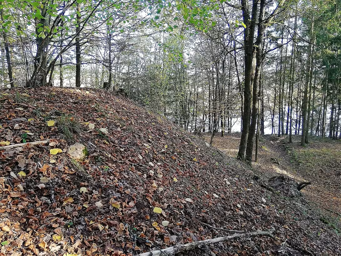
Hradiště Na hradu, also known as the castle of Litoradlice, is an ancient and early medieval fortified settlement above the left bank of Vltava near the village Temelín. This protected cultural monument is significant thanks to long settlement and strategic location within the network of defence stations in southern Bohemia.
The oldest use of the site is evidenced by the finding of a bronze needle with a ball head from 2007, originating in the final phase of the older bronze age. The subject is typical of the younger phase of the utenistic culture or the following period of the wind. Archaeological findings confirm that the site was inhabited even in the earlier times of iron and in the early Middle Ages. The building was one of three fortifications situated between Hlukou nad Vltavou and Tyn nad Vltavou, next to the castle Baba and Hradec near Dobříjovice.
The area of 2.8 hectares is built on a triangular edge. Natural protection consists of steep, sometimes rocky slopes to the Vltava, where today there is a brown lake, and a cliff above the castle grate on the north and northwest side. The southwest access side is covered by a double wavy band. The inner one is more powerful; the heel is 5 to 18 metres wide and reaches a height of 5 to 6 metres. Reports from the turn of the 19th and 20th centuries mention a third, external wall that is no longer visible in the field. On the east side there was probably a small, slightly fortified foothold protecting access from the Vltava ford.
Research was carried out by Jan Nepomuk Woldrich, Josef Ladislav Píč and Bedřich Dubský. Professor Woldřich, based on the findings of the burnt layers, classified the site among the fortified castles. In 1942 and 1943 Bedřich Dubský found fragments of early medieval ceramics in the old probes during a surface survey. In the northeastern front was found a decorated overlay from the period of the Hallatian to Latin.
No tourist or information signs lead to the memory. Access is possible from bus stop U two shranky on road III class 12221 between Jeznice and Litoralice. It is also possible to reach here after the cycling route No. 1079 from Hluboká nad Vltavou to Týna nad Vltavou, which is part of the Vltava cycling route.
Hradiště Na hradu presents a valuable archaeological document on the settlement of the Vltava Valley from the Bronze to the early Middle Ages. Visiting this place offers the opportunity to see the remains of prehistoric defence architecture in its natural landscape.
Then and now
Drag the slider to compare how the landmark may have looked when it was built with the view today.
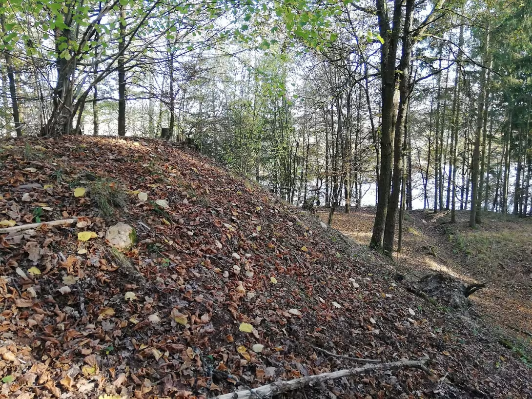
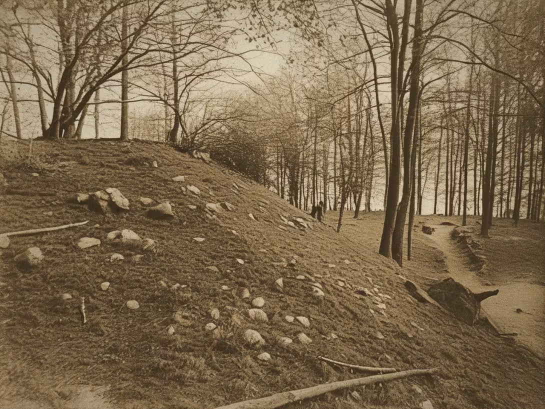
The historical appearance on the left is an AI-generated visualisation and serves as inspiration only.
Historical milestones
- The finding of a bronze needle with a spherical head in 2007 illustrates the use of the site in the final phase of the older bronze age.
Architectural development
The fort is protected by steep cliffs and a double wavy belt. The larger inner wall has a width of 5-18 meters and a height of 5-6 meters. A small front was found on the northeast side with a light fortification.
Historical events
- The archaeological dig was carried out by Jan Nepomuk Woldřich, Josef Ladislav Píč and Bedřich Dubský.
- 1942-1943
- Bedřich Dubský found fragments of early medieval ceramics in old Woldřich probes.
Points of interest
- In 2007, a bronze needle was found with a spherical head from the final phase of the older Bronze Age. - The object was one of three fortifications situated between Hlukou nad Vltava and Tyn nad Vltava. - The inner band measures 5 to 18 metres in width at the heel and reaches a height of 5 to 6 metres. - The locality was classified among the fortified valleys based on the findings of burnt layers. - In the northeast foothold was found a decorated overlay from the period of the Hallatian to Latin.
Guide
Show guide text
This text was created by artificial intelligence and has not been editorially reviewed. It may contain inaccuracies.
Welcome to the place where time seems to be stopped, and yet in every corner of the country there were endless events. You are standing right outside the castle castle castle, which is situated above the left bank of the Vltava village Temelín. If you look around now, you will see a landscape that is inextricably connected to this place. Feel this atmosphere, this calm, but it has traces of ancient turbulence and the constant movement of people who have sought security and strategic advantage here. Look at the surrounding terrain and try to imagine what this ridge looked like thousands of years ago. It is not just an ordinary design, it is a place that has been the heart of this region for centuries.
This site, spread out on an area of almost three hectares, is not just an empty area in nature. It's a fascinating archaeological record of human efforts to survive and organize. Hradiště Na hradu was inhabited in the older iron age and continued in the early Middle Ages. This means that you have just found yourself in a place where different epochs, different cultures and different ways of life have been encountered. People didn't live here randomly. They chose this place precisely because it offers natural protection and a view of the surroundings, which was absolutely crucial at a time when security was the highest priority. This fort was not just homes, it was strength, symbols of power, and points of control over the surrounding territory and the waterways.
Now pay attention to what you see under your feet and around you. Even though nature is now trying to balance these shapes, you can still see the traces of the architecture at the time. Feel the structure of the country that creates specific shapes here. One of the most important elements you can see here are the inner belts of the boulders. These massive structures were in the past the key to defending the entire site. If you look at their progress, notice their dimensions. In the heel, they can measure from five to eighteen metres in width and reach a height of up to six metres. Imagine the monumental. It must have been an incredible job for a man back then, requiring the coordination of entire groups of people to build and maintain such a wall. These walls weren't just a pile of dirt, they were artificial barriers to discourage the enemy and provide protection for those who lived inside.
This object was not a lonely point in the landscape. It belonged to a wider defense system, one of the three major fortifications that was located in this section between Hlukou nad Vltava and Tyn nad Vltavou. That gives us an idea of how organized the defense of this territory was. It was not just one random castle, but part of a strategic network that protected the road along the river.
Although the names of the particular rulers or heroes who once stood here have been lost in the fog of time, their presence is felt through objects left behind. One of the most interesting findings that allows us to look into their daily lives became in 2007. The archaeologists found a bronze needle with a ball head. Imagine this little but incredibly valuable object. This finding shows that the site was used already in the final phase of the older Bronze Age. This needle is not just a piece of metal, it's a bridge between us and the man who lived here a thousand years ago. Perhaps she belonged to a woman who was in this castle adjusting her clothes or a craftsman who worked in the silence of this proposal. This little object tells us that even in times that seem distant and untouchable, there was a life of detail, work, and beauty.
Here is also the greatest mystery of this place. Although we know about the existence of the waves and when people lived here, many questions remain unanswered. What exactly did the structures that stood at the top of these waves look like? What did their houses look like and how did people move in this space? Archaeology gives us fragments, pieces of the puzzle, but the whole picture remains partially hidden beneath the layers of the earth. Every other find like the bronze needle helps us fold this puzzle a little bit better. It's a constant process of discovery that teaches us humility to history.
Now, I'd like to invite you to continue your search of this premises. Let the atmosphere of this place drift. Walk along the line of the waves, try to visualize the height and the force that these structures once radiated. Look at the surrounding landscape and realize how important this position was to the people at the time. Every step of this castle is a step in time. Feel the silence that exists here, and remember the thousands of years this place has lived. Thank you for choosing to visit this history and devote your attention to its secrets. Brig you another trip through this fascinating territory.
Tips for visitors
For the best experience we recommend a visit during spring or autumn, when the weather is pleasant for walks and nature offers beautiful colors. The best time for photography is just before sunset, when light beautifully highlights the shape of the terrain above the Vltava shore and creates interesting shadows on historical structures.
The location can be reached by car and through public transport. The current traffic connections and parking possibilities in the Temelína area please check in advance in the web search engines or on the official website of the carriers.
Since it is a large area in the natural environment, it is necessary to bring with you comfortable shoes suitable for uneven terrain. It is also advisable to have plenty of drinking water and, if necessary, own refreshments that you can enjoy during the tour in nature.
For families with children the castle is a great place for active stay in the fresh air and exploring history. It should be assumed, however, that due to the natural nature of the castle, the journey for strollers may not be quite comfortable, so they are more suitable for the youngest children.
Businesses nearby
Do you run a restaurant, accommodation, shop, museum, rental, wellness or other visitor service near this monument? Show yourself directly to the people heading to it — this is how they will see you in the app and on the web:
Events nearby

Zdroj akcí: otevřená data měst a obcí ČR (Národní katalog otevřených dat) a kalendář akcí Národního památkového ústavu.
Nearby
XXXHistorical monuments (72)
- Museum of Historical Vehicles 3.5 km
- Museum of Historical Vehicles and Old Agricultural Technology 3.6 km + 420 604 675 031 web
- XZ0Z105ZX 3.6 km web
- sv Jan Nepomucký 3.7 km
- Memorial of fallen private 3.7 km
- Master Jan Hus 4.0 km
- Monument of the fallen 1st and 2nd World War 4.1 km
- Monument of vorosava 4.1 km
- Hall of Voronavigation 4.3 km web
- Castle High Hrade 4.9 km
- Monument fallen from the Baptist 5.3 km
- Monument fallen from March and Supporting 5.3 km
- Eleonora Gayer 5.8 km
- Charles Castle 6.1 km
- U killed 1980 6.3 km
- Memorial to the victims of the two world wars 6.3 km
- lock Týn nad Vltavou 6.8 km
- Jiří Straka 6.9 km
- Irma Strakova 6.9 km
- Karel Straka 6.9 km
Restaurant and catering (90)
- Tahoda On the site 3.3 km
- U Janáts 3.9 km
- Restaurant Pelican 4.0 km
- Eurest 5.2 km
- Hostin u Hrodlice 5.9 km
- MaloParty Restaurant 6.1 km + 420 606 415 004
- Restaurant Žimutice 6.3 km
- Art Caffe Bar 6.4 km Nábře 5th May 199 + 420 777 578 273
- Restaurant Podskalí 6.5 km Legion 154
- U Voraø 6.6 km
- Hossovka Kacovská turret 6.6 km Žžkova 562 + 420 774 530 005
- Pizzeria della Piazza 6.7 km Square of Peace 92
- Restaurant Golden Boat 6.7 km Square of Peace 251
- Pizzeria Contact 6.8 km Vesel 747 + 420 728 194 085
- Kebab House 6.8 km Horní Brasov 18
- Plzenka 6.9 km web
- Castle Restaurant 6.9 km
- Bernard Bar 6.9 km
- Queens Bar 6.9 km
- Restaurant Sports hala 7.2 km Tyršova 780
Accommodation (29)
- Autokemp 2.8 km
- Relax Hotel 4.0 km
- Farm Expression 6.4 km + 420 775 963 325; + 420 774 297 220 web
- Pezion under churches 6.6 km + 420 602 138 153 web
- Blanice 6.8 km
- Plzenka 6.9 km
- Castle guesthouse 6.9 km
- František Hovorka 7.9 km + 420 777 099 294
- Camping Corporations 10.1 km
- Prima 10.2 km Tyn over Vltavou 1
- Křivonoska 10.6 km + 420725959497 web
- Guesthouse U Uštrosa 11.3 km + 420 606514991 web
- Accommodation Girls 11.7 km + 420 777668924 web
- L-Club 12.4 km + 420 387 965 523 web
- Štekl 12.7 km + 420 387 967 491 web
- Hotel Podhrad 12.7 km + 420 387 983 690 web
- Recreation Centre New Louka 12.7 km
- Sporthotel Barborka 12.8 km
- Hotel Vish from Falkenstejna 12.8 km + 420 387 966 666 web
- Hotel Princing House 12.8 km + 420 387 983 690 web
▶ Rental and Sport (13)
- Purkarec 4.1 km
- Charles Castle 6.2 km
- Kanoist Spark Club KKJ Týn nad Vltavou 6.4 km Salt 422 web
- Cyclosport 6.6 km
- Na Palubu 7.1 km
- Sport hala 7.2 km
- SK Šivetín 11.1 km
- Deep over Vltavou 12.4 km
- Mech Wall 12.8 km
- Deep over Vltavou 13.0 km
- YC DIM 14.4 km
- TJ Slavoj 14.6 km
- JOLA 14.7 km
© Tourism and Nature (82)
- _ 3.4 km
- Study 4.2 km
- Bučí 5.9 km
- Havlickova 6.2 km
- Good VodaxZ4ZX 6.2 km
- Bedřich Sets 6.6 km
- Red top 6.8 km
- Park Youth 6.9 km
- Park U Cemetery 7.0 km
- Pumpak 7.0 km
- Jeling jump 7.0 km
- Study at the cycle path 7.2 km
- Big Stone 7.5 km
- Horax4ZX 7.6 km
- U Cross 7.6 km
- Ve smurf 7.7 km
- View Semenec 7.8 km
- Kameniste 7.9 km
- Semenec 8.3 km
- Olešnský ště 8.6 km
Accommodation nearby
Trips and activities nearby
Guided tours, tickets and activities nearby from GetYourGuide
Affiliate link: if you buy from the partner, we may receive a commission. The price for you does not change.
Search tours and activities →Themed route
1. Hradiště Na hradu (Type: archaeological monument) - You will explore historical territory with a rich past. 2. Earth walls (Type: archaeological object) - You'll look at the remains of ancient defense structures. 3. Central space (Type: castle area) - Take a walk around the place where the daily lives of the people once took place. 4. Top point of the castle (Type: sightseeing) - You will get an overview of the entire scope of the monument and its strategic location.
Seasonal recommendations
Spring At the castle in Temelín you will be welcomed during this period by the awakening nature and fresh green vegetation. The soft spring sun beautifully accentuates the shapes of old valleys and creates a pleasant atmosphere for walks. We recommend taking layered clothes because morning temperatures can still be low. This is the perfect time to visit, because you will avoid the biggest crowds of people and enjoy the quiet in the blooming surroundings.
Summer The summer months bring intense sunlight to the castle and a full bloom of the surrounding landscape. The day is long, offering rich possibilities for a tour, but high temperatures can be challenging. For the best experience, we recommend arriving early in the morning to avoid the morning heat and the largest number of visitors. Remember enough drinking water, headgear and light, breathable clothes.
Autumn Autumn visit offers a fascinating view of the golden and brown shades of leaves that surround the historic place. The morning fog gives the castle a mysterious and melancholy mood that matches perfectly with its historical monuments. Due to the variable weather, it is advisable to carry a waterproof jacket and tight shoes for possible wet trails. The afternoon light is most suitable for photography during this period.
Winter In the winter, the castle is rough and majestic in a landscape without leaves. When snow comes, the monument looks magical, but it seems very quiet and remote. It is necessary to prepare for the cold, so choose a very warm and breathable garment and high quality shoes. Since the days are short, plan to visit in the clear hours of the day when the light is most, and count on you to meet only a few people in this period.
Visualizations and artistic views


The visualisations are generated by artificial intelligence and serve as inspiration.
Tips from visitors
No tips yet. Be the first!
Log in and add your tip.
Sources and literature
Fotografie: Karelkam / CC BY-SA 4.0 — Wikimedia Commons. The author and licence also appear when you hover over the image.
Faktickým podkladem tohoto textu byl článek na Wikipedii, jehož autory jsou přispěvatelé Wikipedie. Článek je dostupný pod licencí CC BY-SA 4.0.
Location on the map
Příběhy a pověsti
Legendy, pověsti a příběhy spjaté s touto památkou

Fotografie návštěvníků
Zatím žádné fotografie. Buďte první, kdo přidá fotografii z návštěvy!
Přihlaste se a přidejte svou fotografii nebo hodnoťte.
Za ověřenou návštěvu v aplikaci získáte víc bodů — poznáme podle GPS, že jste na místě.
Reviews and comments