



inundační most v Lounech Inundation bridge
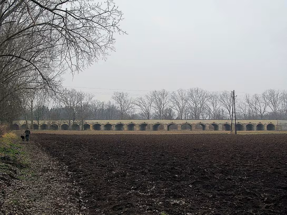
The Inundation Bridge in Louny is a classic brick building in the flood area between Louny and Dobrometry. With a length of 272 metres it represents the longest object of its kind in the Czech Republic. Since 1964 it has been registered as a cultural monument. Together with the bridge across the Ohres River, they form a unified complex. He served to secure connections with villages north of the city and to transit through the road from Prague to Saxony.
Bridging requirements Fires have existed in this location since the founding of the city in the 13th century. The first written mention of the bridge dates back to 1295, when the widow Měčka referred her yard in Dobroměřice to the repair of wooden construction. In the 15th century, the buildings were gradually restored. Wood was purchased in 1462 and in 1469 there is a mention of a bridge in the accounts to the suburbs of Venice. In 1543, the miller Jakub z Litoměřic built a new covered bridge with shingles roof, but burned by the Swedish army in 1640. Further wooden structures from 1667- 1668 followed and repairs in the 18th century. In 1896 the bridge was replaced by a steel lattice bridge.
The first inundation bridge was probably built at the beginning of the 16th century from wood to avoid interruption during frequent floods. In 1543 and 1544 it was replaced by a stone bridge whose road was paved in 1562. The stone for construction was imported from the quarries of Lipence. This original object was captured by Jan Willenberg in 1602. The construction consisted of six arches towards Venice and four arches leading towards Dobrometry. According to Chronicator Pavel Mikšovice, part of the bridge was torn down in 1605 and the material was used for a new construction.
The current inundation bridge was established in connection with the Naples Wars. It was necessary to ensure the smooth movement of armies along the road to Leipzig. The construction began in 1804 by building the first six arches. By 1816 the majority of 36 arches were formed and the final form was acquired by the object in 1863.
The construction is built from sandstone and petal blocks on the ground plan of a wide arch. The bridge has a width of eight meters and a height of seven meters along the edge of the parapet. The whole building consists of forty pillars with a width of one metre. These are connected by a valence vault with a span of six meters and a height of five meters. Pillars have semicircular corners and above each arch there is a gutter, so called gargoyle, which provides drainage of the road.
The monument is a unique testimony about transport infrastructure during the period of the Napoleonic wars and technical solution of the flood area. Its record length and preserved brick construction make it an important target for every interested in historical architecture.
Historical milestones
- 1964
- The Inundation Bridge was registered as a cultural monument.
- 1804
- Starting construction of the first six arches of the current inundation bridge.
- 1863
- The bridge has acquired its final form.
Architectural development
The first stone inundation bridge was built in the 16th century and was captured by Jan Willenberg. The current inundation bridge was built gradually from 1804, with the majority of its forty pillars and vaults formed by 1816 and the final form was obtained in 1863. In particular sandstone and sputum blocks were used for the construction, and above each arch there is a sink providing drainage.
Historical events
In 1964, the bridge was registered as a cultural monument. During the 17th century, the neighboring bridge over the Ohres was burned by the Swedish army. In 1804, the construction of the existing inundation bridge began in connection with the Naples wars.
Points of interest
- With a length of 272 meters it is the longest object of its kind in the Czech Republic. - Since 1964, the building has been registered as a cultural monument. - The current bridge was built in connection with the Naples Wars for the smooth movement of armies towards Leipzig. - The construction consists of 36 arches and 40 pillars. - For drainage of the road is used the gills which are located above each arc.
Guide
Show guide text
This text was created by artificial intelligence and has not been editorially reviewed. It may contain inaccuracies.
Welcome to the Louns. Right now, you're facing one of the most fascinating construction works in our region. In front of you, there is an inundation bridge, a building that can act at first glance as a simple travel link, but in fact it is a monumental testimony of the human effort to control nature and ensure safe passage in dangerous areas. Look at this infinite line of arches that stretches through the landscape between the Louns and the Dobrometers. It's a view that makes you stop and think about how much work and effort has been put into every single stone you see here.
Let us now return together in time to understand why this bridge was even built. Imagine the early nineteenth century. Europe was in the flames of the great war conflicts led by Napoleon's famous army line. It is these Napoleon wars that have been the main impetus for the creation of the building that you are facing. At that time, it was crucial to ensure the smooth and rapid movement of military troops on the road, particularly towards Leipzig. However, the problem was the flood area, which prevented any movement during the high waters. It was provided that the troops must not be stopped by water, so there was a need to build a bridge that would remain functional even at the highest level of the river.
Construction was not a one-off act, but a long process. It all began in eight hundred and four years, when the first six arches of the current bridge were built. The whole project was then gradually expanded and finished, until in the year one thousand eight hundred sixty-three it gained its final form, which you see today. This whole process was conducted under the supervision of experts, among whom the builder Josef Bachmann excelled. Together with other personalities such as Jakub z Litoměřic or Pavel Mikšovich, they formed a team that had to solve complex technical problems associated with unstable subsoil in the flood zone.
Now please pay attention to the architecture itself and the details surrounding you. If you look closer at the structure, you'll notice that the bridge is made up of sandstone and peeling blocks. These are solid stone blocks that have been carefully carved and assembled to withstand water pressure and heavy chariots and forces. Follow the rhythm of the building. The bridge consists of 40 pillars which hold the whole structure above the terrain. Among these pillars are then recorded rolling arches, of which there are six and thirty. These arches are not only an aesthetic element, but they are used for effective weight distribution while allowing water to flow freely under the bridge in the event of flooding without destroying it.
Try to realize the extent of this work. If you look along the entire length of the bridge, you'll see how far it goes. The total construction length is two hundred and sixty-two metres. This is a number that really ignites in the context of Czech buildings of this kind. The Inundation Bridge in Louny is the longest construction of its kind throughout the Czech Republic. He's a real record man who dominates the surrounding landscape with his size. Imagine how many thousands of stones had to be transported to this place and how many hands had to fit into each other to form this continuous line of stone.
It is fascinating to think that this bridge has been a strategic point in the past. Imagine the dust from thousands of military boots, the clanging of weapons and the rumbling of the wheels that flowed through here towards Leipzig. The bridge was not just a path, it was an instrument of power and logistics. At the time, it was not about the beauty of architecture, but about pure functionality and reliability. Yet with time, he became a jewel that we still value today. That's why it was officially listed as a cultural monument in the year one thousand nine hundred sixty-four. By this recognition, the State confirmed that the bridge had irreplaceable historical and technical value.
Now, when you look around, feel the atmosphere of this place. You're standing at the point where the need for military strategy meets the stonemasons' championship. It's a place where it shows how people were able to build something that survived the century in the summer before modern technology and still stand like a solid wall against elements. Note how the color of sandstone and sprays changes depending on the light and how the bridge naturally enters the surrounding nature.
The interesting thing that might interest you is the combination of materials. Sandstone and opaka have different properties, but their connection in this bridge has ensured stability that is necessary for the construction of the flood area. It's a fascinating example of engineering thinking at the time, where the worst-case scenario, the big water, could wipe everything out.
Now let's close this chapter slowly. The Inundation Bridge in Louny is not just a pile of rocks, but a story about people who wanted to overcome the obstacles of nature. It's a monument to endurance and precision. I hope that when you look at these arches and pillars, you could imagine how important this bridge was to people two years ago and why today it is so important to look after it.
I ask you now for further examination. Go through the bridge in peace, perceive its massiveness, and perhaps stop by one of the pillars and touch the cold stone that remembers Napoleon's time. Let yourself be guided by the silence of the surrounding countryside and enjoy this moment of peace at one of the longest buildings of your kind in our land.
Thank you for your attention and I wish you a pleasant journey along the beautiful Louns and their surroundings. Goodbye.
Tips for visitors
The best time to visit the London Bridge is early in the morning or late in the afternoon, when the sun's rays create soft light ideal for capturing a massive stone structure extending two hundred seventy-two metres long. You can use a passenger car or local public transport to travel to the site, whose current connection can be easily verified in an online search engine. Take with you a walk through the flood area comfortable shoes suitable for nature and in warmer months also a headgear and a supply of drinking water, because the whole area is unshadowed. The best places for photography can be found on grass banks between the city of Louny and the village of Dobroměřice, from which you can see the long line of arches forming a uniform complex with the river Ohří. In the vicinity you can admire the natural nature of the flood area and the meadows that connect Louny with the Dobrometry, so enjoy the peaceful atmosphere of this unique landscape.
Frequently asked questions
Can the monument be visited?
This is a structure in a public space that can usually be seen from outside free of charge. We have not verified that this particular one is freely accessible.
Where is the monument?
Location: Louny. The map on this page shows the exact spot.
Why is the monument protected?
It is listed in the Central List of Cultural Monuments of the Czech Republic as a cultural monument (register no. 1000155928).
Businesses nearby
Do you run a restaurant, accommodation, shop, museum, rental, wellness or other visitor service near this monument? Show yourself directly to the people heading to it — this is how they will see you in the app and on the web:
Nearby
Okolí tvoří záplavové území a louky mezi městem Louny a obcí Dobroměřice, přičemž památka tvoří jednotný komplex s řekou Ohří.
Accommodation nearby
Themed route
Here is the design of the thematic route:
1. City Louny - Default point of the journey. The place where the walk begins towards the river.
2. Inundation bridge in Louny - The main destination of the trip. A unique building that forms with the Ohří River a uniform complex.
3. Flood area and meadows - Natural space between the city and neighbouring village. Ideal place to observe the landscape around the river.
4. Municipality of Dobrometry - End point of the route. The village lies on the other end of the meadow.
Seasonal recommendations
In spring, the surroundings of the bridge awaken to life and green grass highlights clean lines of construction. The light is soft in this period, which is ideal for observing details from the outside. We recommend shoes suitable for wet terrain and visit in the morning when the air is the cleanest.
In the summer months it dominates the scene of bright sun and hot air. The bridge looks very bright, while summer plants bloom around. It is advisable to choose light clothes and a hat, the best time to visit is early morning or late evening to avoid the biggest of the Closing Hot.
Autumn brings gold and brown colors to the landscape that create a melancholy atmosphere. Fogs can be seen around the structure, which gives the place mystery. It is practical to take with you a waterproof jacket and visit a monument in the afternoon when the sun paints the landscape in warm tones.
Zimą is usually quiet and minimalist around the bridge, especially if the surfaces are covered by snow. The contrast between the white landscape and the bridge material is very strong. It is necessary to wear warm winter clothes and firm shoes with anti-slip soles, while a short walk is best in time around the winter solstice.
Visualizations and artistic views

The visualisations are generated by artificial intelligence and serve as inspiration.
Photos from the area
Real photos taken near the monument


Zdroj a licence jsou uvedeny u každého snímku.
Tips from visitors
No tips yet. Be the first!
Log in and add your tip.
Sources and literature
Photos: Gortyna / CC BY-SA 3.0 — Wikimedia Commons. The author and licence also appear when you hover over the image.
Faktickým podkladem tohoto textu byl článek na Wikipedii, jehož autory jsou přispěvatelé Wikipedie. Článek je dostupný pod licencí CC BY-SA 4.0.
Location on the map


Příběhy a pověsti
Legendy, pověsti a příběhy spjaté s touto památkou
Fotografie návštěvníků
Zatím žádné fotografie. Buďte první, kdo přidá fotografii z návštěvy!
Log in a přidejte svou fotografii nebo hodnoťte.
Za ověřenou návštěvu v aplikaci získáte víc bodů — poznáme podle GPS, že jste na místě.
Reviews and comments