



most Lštění - Čtyřkoly Bridge
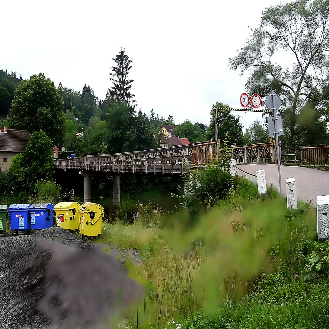
The four-wheel bridge - Lštění brightens Sazava on its 35th kilometer in Benešov and is a property of half of the municipalities of Four and Lštění. Instead of today's construction, a rope ferry used to serve. In 1949, immediately after World War II, a British folding bridegroom bridge of Bailey construction was posted here, marked Mk III - Model 3. The bridge came from UNRRA sources, an organization designed to rebuild a war-torn Europe. Originally, he was only supposed to serve temporarily for only ten years.
There was a serious test in the mid-1980s. The icebergs, up to 40 centimeters thick, have severely damaged the bridge. In 1985 (possibly 1982), the concrete column replaced two original wooden supports which destroyed the frost. Although the bridge still served, age was signed on a wooden bridge. It was closed in May 2011. The repairs lasted more than a year - 18 November 2012 reopened.
The new bridge replaced the wood with Prefagrid glass by Prefa in Brno. Sixty grids of 3600 × 1200 × 38 millimetres were used. Vehicles may now weigh up to two tonnes and shall not exceed 210 centimetres. Trailers at the raid warn: "Only one vehicle on the bridge" and "Drive slowly." The financing of the repair was a challenge for small municipalities - both shared 700 thousand crowns, the Ministry of Regional Development added another 600 thousand. A general recovery would cost seven million.
Originally, Bailey Bridge had three fields and served for freight. Now it has two fields, supported by a concrete pillar in the middle. Configuration 2 / 1 indicates that it was intended as new for vehicles of medium weight rather than for heavy machinery. In November 2015, the month was closed due to the construction of a group tap. From 3 September 2024 it is closed again for detailed inspection and subsequent repairs. The closure was extended until 31 May 2026 due to difficulties in competing for steel elements. There is a red-marked hiking route leading over the bridge.
Then and now
Drag the slider to compare how the landmark may have looked when it was built with the view today.
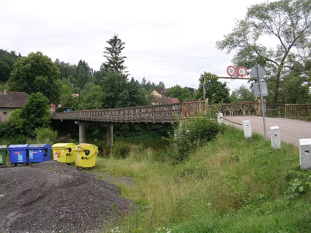

The historical appearance on the left is an AI-generated visualisation and serves as inspiration only.
Historical milestones
- 1949
- Completion of bridge construction as a transitional construction by UNRRA.
- 1985
- Repair damaged wooden supports with concrete pillar.
- 2011
- Close the bridge for emergency condition and subsequent bridge repair.
- 2024
- The beginning of the long-term reconstruction and closure of the bridge for general repairs.
Architectural development
The bridge was built as a folding structure of steel, originally with a wooden bridge. In 1985, there was a fundamental change in the aid when two original wooden supports were replaced by one concrete pillar. In 2012, the wooden bridge was replaced by prefabricated grates from the non-absorbent glass laminate of Prefagrid. The bridge was originally designed for moderate transport, not heavy armoured equipment.
Historical events
- 1949
- The position of the bridge as the British bridal bridge construction Bailey Mk III by UNRRA.
- 1985
- Replacing two original wooden supports with a concrete pillar damaged by ice-cold cows.
- 2011
- Closing the bridge due to the emergency condition of the wooden bridge, then opened in November 2012 after repair.
- 2024
- Close bridge for detailed inspection and repairs, planned extension of closing until May 2026.
Owners
The bridge has been jointly owned by the municipalities of Four and Lštění since 1949.
Points of interest
- The bridge was originally built in 1949 as a temporary British bridegroom bridge like Bailey, delivered from UNRRA.
- In the mid-1980s, it was damaged by ice crees up to 40 centimeters thick, which required the replacement of wooden supports.
- In 1985 (or 1982) the concrete column replaced two original wooden supports which destroyed the frost.
- In May 2011, the bridge was closed for repairs that lasted until 18 November 2012.
- The new bridge is made of sixty fiberglass grates of Prefagrid 3600 × 1200 × 38 millimetres.
Guide
This guide is narrated by a synthetic voice generated by artificial intelligence.
Show guide text
This text was created by artificial intelligence and has not been editorially reviewed. It may contain inaccuracies.
The bridge between Čtyřkoly and Lštění carries a publicly accessible utility road across the Sázava River. It is located in the Benešov district and belongs half to the Čtyřkoly municipality and half to the Lštění municipality. On the Čtyřkoly side, it is connected only to a local road, while on the Lštění side, a ramp leads from a third-class highway.
Previously, a rope ferry transported people across the river here. The bridge was built in 1949 and is an original British folding military bridge of the Bailey type, designated as Mark 3, meaning model 3. It came from supplies by the UNRRA organization and was meant to serve only temporarily, for about ten years. It was built in a two-and-one configuration, so it was designed for medium-weight vehicles, mainly trucks, not for heavy armored equipment.
Originally it had three spans. In the mid-eighties, ice floes up to forty centimeters thick damaged it. This was followed by extensive repairs, and the two original wooden supports were replaced with a concrete pier in the middle. This happened in 1985, or according to another account, already in 1982. Since then, the bridge has had two spans and serves passenger vehicles and pedestrians.
At the end of May 2011, the bridge was closed because the mainly wooden deck was in very poor condition. It reopened on November 18th, 2012. The wood was replaced with non-absorbent fiberglass grids made by Prefa Brno. There were sixty of them, and each measured 3600 by 1200 millimeters. There was no money for the general repairs costing 7 million crowns. Both municipalities therefore contributed 700 thousand crowns from their strained budgets, and the Ministry for Regional Development added another 600 thousand. The bridge still supports only vehicles up to two tons and 210 centimeters in height.
The municipalities considered installing a traffic light that would allow only one car on the bridge at a time, and there was also talk of tolls. Due to high costs, however, they settled for signs reading "Only one vehicle on the bridge" and "Drive slowly."
In November 2015, the bridge was closed for a month due to water pipeline construction to Benešov. Another closure began on September 3rd, 2024 due to detailed inspection and repairs. It was progressively extended until May 31st, 2026, because they failed to contract a company for manufacturing the steel construction components.
A red-marked hiking trail crosses the bridge.
Frequently asked questions
Can the monument be visited?
This is a structure in a public space that can usually be seen from outside free of charge. We have not verified that this particular one is freely accessible. According to the heritage register restoration is under way, so access may be restricted.
Where is the monument?
Location: Lštění, Středočeský kraj. The map on this page shows the exact spot.
For kids
Imagine going back to the past... Until the Lštění Bridge was still one of the oldest bridges in the country. It was a time when people lived far away from cities and big city centers when the Otava River was their main path.
Businesses nearby
Do you run a restaurant, accommodation, shop, museum, rental, wellness or other visitor service near this monument? Show yourself directly to the people heading to it — this is how they will see you in the app and on the web:
Events nearby

Zdroj akcí: otevřená data měst a obcí ČR (Národní katalog otevřených dat) a kalendář akcí Národního památkového ústavu.
Nearby
Around the bridge there is a natural landscape with the river Sazava and surrounding field formations. In the vicinity (up to 5 km) there are, for example, four-castle (18th century castle) and several historical settlements in the municipalities Lštění and four-kol.
Accommodation nearby
Themed route
Historical estate in Lštění - architecture. Tour of traditional buildings in the village Lštění. 2. Most Lštění - Four Colors - monument. The main destination of the trip, which connects both municipalities. 3. Sázav - nature. Walk along the river and the surrounding field formations. 4. Castle 4. Historical residence within 5 kilometers from the bridge. 5.Historical homestay in Four Koly - architecture. Final stop at historical buildings in the village of Four.
Seasonal recommendations
Spring brings new life energy to the vicinity of the Lštění Bridge, where green vegetation begins to develop and fine morning light highlights the contrast between the historical site and the ongoing restoration. The atmosphere is fresh and full of hope, which is ideal for nature lovers. It is advisable to choose layered clothes to protect you from changing temperatures. Due to awakening soil and possible rain, prepare for a less stable terrain near construction works.
In the summer months they dominate intense sunlight and long days that allow detailed observation of the surrounding landscape paradise. In the main summer season we recommend arriving as early as possible in the morning to avoid the greatest heat and possible crowds of people. Don't forget the sun protection, plenty of fluids and light clothes. Due to ongoing reconstruction, prepare dust protection, which can fly in the air during the dry season.
The autumn season offers an unmistakable melancholy, when the landscape is painted in golden and brown shades and morning fog often cloaked the surroundings in mystery. Low sun creates very atmospheric shadows that perfectly complement the historical character of the monument. For a safe walk I recommend fixed and waterproof shoes because wet leaves can make the roads slippery. It is best to schedule a visit in the morning before the day begins to move quickly away from the shear.
Zimą makes the monument very raw and peaceful, especially when frost and snow highlight the shapes of historical structures and bare branches of trees. The atmosphere is quiet and remote, allowing a deep perception of the place. Due to low temperatures and shorter times of the day, it is absolutely necessary to choose a very warm and wind-proof equipment. When moving around the reconstruction, be more careful about possible ice and always check that all access routes are available before travelling.
Visualizations and artistic views


The visualisations are generated by artificial intelligence and serve as inspiration.
Photos from the area
Real photos taken near the monument


Zdroj a licence jsou uvedeny u každého snímku.
Atmosphere of the place
This atmospheric visualisation of the place and period was generated by artificial intelligence. It is not real footage of the location.
Tips from visitors
No tips yet. Be the first!
Log in and add your tip.
Sources and literature
Photos: cs:ŠJů / CC BY-SA 3.0, rozlišení zvýšeno umělou inteligencí — Wikimedia Commons. The author and licence also appear when you hover over the image.
Faktickým podkladem tohoto textu byl článek na Wikipedii, jehož autory jsou přispěvatelé Wikipedie. Článek je dostupný pod licencí CC BY-SA 4.0.
Location on the map
Příběhy a pověsti
Legendy, pověsti a příběhy spjaté s touto památkou
Fotografie návštěvníků
Zatím žádné fotografie. Buďte první, kdo přidá fotografii z návštěvy!
Log in a přidejte svou fotografii nebo hodnoťte.
Za ověřenou návštěvu v aplikaci získáte víc bodů — poznáme podle GPS, že jste na místě.
Reviews and comments