






Plasy Hillfort
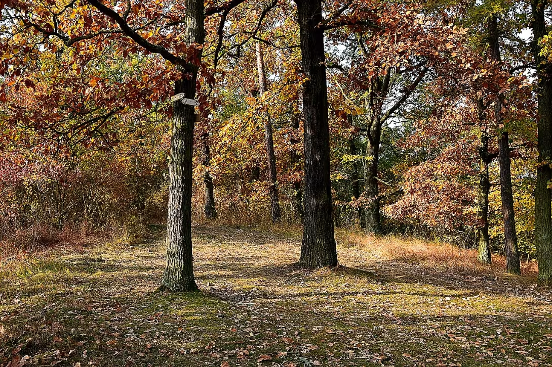
Plasy are an ancient castle on the island of Pilsen-North district, inhabited in eneolithic and later in the period of Halštatian. The monument is protected from three sides by the River Strela and is a part of the register of cultural monuments of the Czech Republic.
The human presence here lasts from eneolite (3200-2800 BC), the period of development of the first centres and copper use in Europe. Subsequently, another settlement was created here in the Halštat era, which is the blooming of the early iron age in Central Europe. The exact time of fortification is unknown, but it probably comes from a later phase.
The site occupies a narrow island area of about one hectare, the strategic location of which uses natural water barriers. In the south, the object with the surrounding terrain is connected only by a narrow neck, lined with an arc wave about 15 metres long and up to 1.2 metres high. At the ends the wall turns and continues along the side sides as a terraced formation.
In the past, the castle was called the Upper Hradiště according to the village on the opposite bank. In 1980 Jaroslav Bašta and Dara Baštová conducted a survey research in which they discovered a stone axe and fragments of eneolithic ceramics. The 1999 surface collection brought shards from the late Halloween period and from the period of Champ culture.
The monument lies about two kilometers northwest of the city of Plasy. As a cultural monument of the Czech Republic it represents an important proof of the prehistoric settlement of the region.
This archaeological site offers a unique view of the strategic use of the terrain in prehistoric times and is suitable for those interested in the early history of Czech countries.
Historical milestones
- 3200-2800 B.C. l.
- The first human presence in the period of eneolite.
- 800-450 B.C. l.
- A settlement in the Halloween era, a bloom of an early iron age.
- 1980
- Detection archaeological research, finding a stone axe.
- 1999
- Surface collection of shards from the Halloween period and the Champ culture.
Architectural development
The fort is built on a narrow sharpness, where the southern side is connected with the terrain only by narrow neck. This part is lined by an arched wall of approx. 15 metres in length and height up to 1.2 metres. The side sides of the island hall are finished with terraces.
Points of interest
- The fort is protected from three sides by the River Shrela and occupies a narrow island with an area of about one hectare. - In the past the monument was named Upper Hradiště according to the village on the opposite bank. - The southern part of the building is lined with an arc wave about 15 metres long and up to 1.2 metres high. - Research from 1980 brought the findings of stone axe and fragments of enolithic ceramics. - The 1999 surface collection revealed shards from the late Halloween period and the period of the Champ culture.
Guide
Show guide text
This text was created by artificial intelligence and has not been editorially reviewed. It may contain inaccuracies.
Welcome to the place where time has stopped and where nature is trying with its strength to cover the tracks of ancient people. You're standing in front of the plasma archaeological site. Before you go any further, stop for a moment and observe the surroundings. Look at this narrow island you're standing on right now. Can you feel the energy of the place that was chosen for its unusual location? Three sides of this territory are surrounded by the River Shell, which acts here as a natural, impenetrable defensive wall. This water, which is now calmly flowing around, was once a key element that gave people security and protection. Feel the atmosphere of peace, but also the strategic importance that radiates this place. This narrow rock, which occupies about one hectare, has been home for thousands of years to those who have sought safe haven.
Now let's go back deep into the past together and understand why people chose this very place. This country has not always been as quiet and empty as you know it today. The first signs of human presence can be traced back to the period of eneolite, i.e. the period of copper, roughly between the years they are shaking thousands and 2,000 eighty years ago. Imagine the world back then, the world of the first farmers and people who started working with metals. This was the era of great change when mankind began to organize into larger groups. Later, at the time of the Halštats, that is, in the early iron age, this castle experienced its true bloom. Between the years of eight and four hundred fifty years before our current number of years, life was pulsing in full force. This era has brought new technologies and greater complexity of life. People here created a stable settlement that used every piece of this terrain to defend and live. The strategic position on this sharpness was not random; It was a choice between survival and extinction.
Now pay attention to what you can see right around you. Even though you will not find here today tall walls, stone towers or monumental gates, the trace of the construction works at the time is still present in the very face of the landscape. If you go towards the southern part of this site, notice the specific shape of the ground. There is a visible arch wall, which measures approximately 15 meters in length and its height is up to a meter and 20 centimeters. This wall was not only a random ridge of the earth, but an important part of the defense system, which was intended to protect the inhabitants of the castle from enemies. Even though this wall is now just a shadow of its past size, it still reminds us of the huge amount of work and effort that people had to make to secure this place. The total area of the castle, that is, this one hectare, had to be used with incredible precision to find room for homes, work and defence in this limited area.
Although we do not know the names of the particular leaders, kings or builders who built this castle, their stories are written to us in the country itself through the findings made by archaeologists here. Every such find is like a piece of lost mosaic. In the year of a thousand and nine hundred and eighty, an object was found here in the research, which enabled us to better understand the life of that time - a stone axe. Imagine the moment when someone used it to work, build or hunt thousands of years ago, and then left it here. The axe is a symbol of human art and an effort to manage the environment. Another important moment was the year one thousand nine hundred ninety-nine, when shards of ceramics were found in the surface collection. These tiny fragments belong to the Hallatians and also to the Champ culture. Even if it's just small things, it's these shards that tell us what people ate, what containers they used to store supplies and what their daily rituals looked like. These unknown persons who lived here left us their presence through these tiny but extremely valuable clues.
If you want to think a little bit more, did you know that this place has another history related to his name? In the past, this castle was called the Upper Hradic. This name did not refer to the architecture itself, but to the village located on the opposite bank of the river. It is a fascinating example of how people in past times were oriented in the landscape and how their perception of the place was closely linked to the surrounding settlement and the course of the river. This transformation of names and looks at this place shows us how history is constantly burrowing and how new generations are trying to understand what was here before. This strategic position on a narrow sharpness has been used so perfectly for natural defence that even after thousands of years we still feel the power of this place, which has been able to become a solid fortress in the middle of flowing water.
However, we will no longer prevent you from further examination. Take a walk around, feel the rhythm of the River Shots and try to imagine the thousands of years that have taken place here. Every step of this soil is a step of history that was formed here in the time of copper and in the time of iron. Take a look at the details of the terrain, notice the shape of the waves and try to draw a picture of the settlers at the time in spirit. Thank you for choosing to make this journey in time with us. We wish you a pleasant rest of the tour and many interesting experiences in discovering the secrets of this place.
Tips for visitors
For the best experience we recommend a visit during spring or autumn. At these times the surrounding landscape is most picturesque and light is ideal for observing the archaeological structures of the castle.
Archaeological sites can be reached by car and public transport; please check the current transport connections and parking options in pre-prepared transport information.
Bring comfortable shoes suitable for uneven terrain and plenty of drinking water. Due to the position on the sharpness, caution may be needed in the field.
If you are interested in photography, the best light and views can be obtained in the morning or evening hours, especially when looking at the course of the River Bullet, which runs around the castle.
Within a short walk you can visit the village Plasy or take a look at nature by the River Shell. For families with children it is ideal to prepare simple educational games aimed at finding traces of ancient history in the surroundings.
Businesses nearby
Do you run a restaurant, accommodation, shop, museum, rental, wellness or other visitor service near this monument? Show yourself directly to the people heading to it — this is how they will see you in the app and on the web:
Events nearby
Zdroj akcí: otevřená data měst a obcí ČR (Národní katalog otevřených dat) a kalendář akcí Národního památkového ústavu.
Nearby
River Bullet and municipality Plasy.
Accommodation nearby
Trips and activities nearby
Guided tours, tickets and activities nearby from GetYourGuide
Affiliate link: if you buy from the partner, we may receive a commission. The price for you does not change.
Search tours and activities →Themed route
1. Archaeological site Plasy - archaeological site, main destination of the trip. On the ground you can admire the preserved remains of the ancient settlement and get an overview of life thousands of years ago.
2. The site of the site - Tanks and exposition - part of the site with access recruitment and outdoor exposure of artifacts. Walk through the courtyard allows a detailed view of the excavations and informative boards that complement the context of the site.
3. The shoreline - a natural section along the river, about 300 m from the main entrance. A peaceful walk along the water stream offers views of the river, the possibility of observing local flora and listening to the noise of water, which complements the historical experience of the natural dimension.
4. The centre of the village Plasy - the main part of the village, approximately 500 m from the river bank. Here you can soak up the atmosphere of local life, walk on the main road lined with traditional houses and possibly use local civil infrastructure (e.g. a cafe or information board).
5. Return to archaeological entrance - the last section of the route leads back to the starting point, about 200 m down the main road. This section allows you to evaluate the whole walk and recall the main discoveries you saw during the trip.
Seasonal recommendations
Spring on the archeological site in the Plasi brings an awakening landscape where grass begins to green between the rushes and the remains of the walls. The lighting is soft and diffuse during this period, creating a calm atmosphere for field observation without sharp shadows. Nature is alive here, but the surface of the soil can be muddy and slippery sometimes after spring rains, so it is necessary to choose fixed shoes with a good pattern. Since it is an outdoor location without shelters, it is advisable to carry a light waterproof layer. Tourism is still low here in March and April, so you can explore the individual points of the site in peace and without rush. The ideal time is the late morning when the air heats up and the sun starts to illuminate archeological structures better.
Leto offers the longest daylight and the highest temperatures, allowing longer walks around the premises. Specific here is bright, sharp lighting, which stands out for details in stone foundations, but also requires protection from the sun. The atmosphere is more lively because more visitors are coming here, including families with children looking for shade and fresh air. The practical advice is to arrive as early as possible in the morning, ideally before nine o'clock to avoid the biggest crowds and heat. Clothes should be light, breathable and in dark colors that less attract insects, although the risk of mosquitoes is higher in the summer months. Don't forget enough drinking mode and sun cap, because the shady places in the open landscape are limited.
Autumn in the Plasi brings a dramatic change in colors of surrounding vegetation, which contrasts with the grey remains of the walls. The lighting is lower and warmer, which creates a melancholy and thoughtful atmosphere, ideal for photographic images. Nature is about to rest, leaves on the ground can hide smaller archaeological details, but it also makes field orientation difficult. The temperatures are falling, so a layered clothing strategy is needed to make it easy to adapt to changing weather. In this period the crowds are significantly smaller than in summer, so you can spend more time on individual exhibits. It is best to visit in dry days, because rain queues can quickly make roads accessible and leave slippery surfaces.
Winter on this site is a period of silence and relaxation, when the landscape is minimalist and crude. Snow or ice may reveal new perspectives, but also significantly reduce movement. The lighting is short and pale, which requires an earlier departure from the place so that the visit does not turn into a night walk without sufficient lighting. The atmosphere is cold and sharp, which requires maximum insulation. The clothing shall be laminated with an emphasis on thermal insulation, water resistance and wind protection. Practical advice is to verify the current condition of the terrain before the journey, because frozen or muddy soil can be dangerous. In winter months, the visit is less frequent, which ensures complete privacy, but also means that the surrounding services may have limited availability.
Visualizations and artistic views

The visualisations are generated by artificial intelligence and serve as inspiration.
Photos from the area
Real photos taken near the monument


Zdroj a licence jsou uvedeny u každého snímku.
Tips from visitors
No tips yet. Be the first!
Log in and add your tip.
Sources and literature
Photos: Petr Kinšt / CC BY-SA 4.0 — Wikimedia Commons. The author and licence also appear when you hover over the image.
Faktickým podkladem tohoto textu byl článek na Wikipedii, jehož autory jsou přispěvatelé Wikipedie. Článek je dostupný pod licencí CC BY-SA 4.0.
Location on the map


Příběhy a pověsti
Legendy, pověsti a příběhy spjaté s touto památkou
Fotografie návštěvníků
Zatím žádné fotografie. Buďte první, kdo přidá fotografii z návštěvy!
Log in a přidejte svou fotografii nebo hodnoťte.
Za ověřenou návštěvu v aplikaci získáte víc bodů — poznáme podle GPS, že jste na místě.
Reviews and comments