



Staré Zámky Hillfort
Staré Zámky are archaeological sites in Brno-Líšni. It is a significant fortification from the end of neolithic to the beginning of the 11th century. The locality lies on a rocky island in the southern part of the Moravian Karst and is considered a direct predecessor of Brno.
The settlement of the site started in the 5th to 4th millennium B.C. This is confirmed by the findings of ceramics from the late neolithic to early eneolite. During the course of the eneolite, the people of the culture of pinkish cups settled here and later the bearers of the culture with canned ceramics. That's when a densely built estate surrounded by a defensive boulder and a moat was built. The resettlement took place at different times during the Bronze, Latin and early movement of nations.
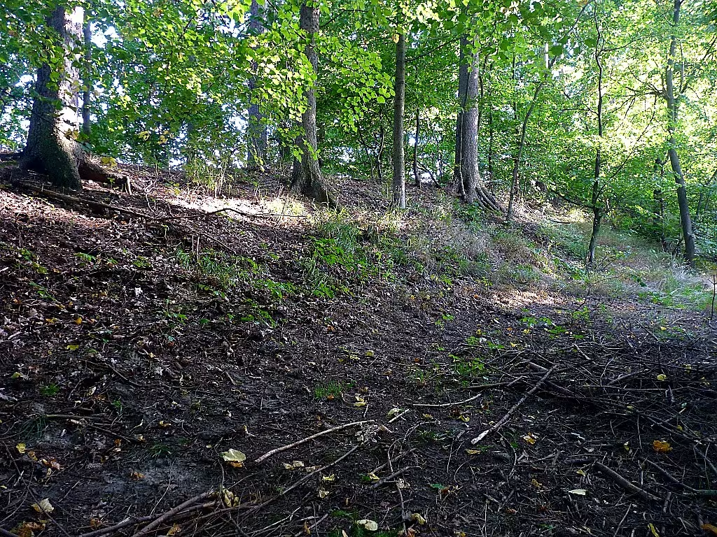
The area of about 13 hectares is situated on a glued rock field, which is surrounded by a river stream on three sides. The territory shall be divided into a central part and a prepaid part. The first is a triangular area of around 4.5 hectares. It was fortified throughout the perimeter, except for the gate in the northeast part, which served to access the water. In the northwest, the foothold separated from the barrier of the armour. In the period of the Grand Moravian, there was an aluminium wall with a wooden palisade. Later there was a massive fortification, cabin buildings, a grand courtyard with a ten-metre wooden guard tower and probably a church. In the field there is still a 320 metres long section of the outer wall in the forest of Halegletunia. It exceeds the surrounding area by 2 to 2.5 metres and adjacent to a two-metre ditch.
In the 19th century the land was owned by Count Belcredi. In 1875 he first published findings obtained in agricultural works. The first archaeological research in the 1980s was carried out by Jan Knies, followed by Martin Kříž and Innocenc Ladislav Červinka. From 1948 to 1965 systematic research was carried out under the leadership of Josef Poulik, Anna Medunova and Čeňka Staňa from the Archaeological Institute of the Czechoslovak Academy of Sciences.
The greatest blossom of the fort was achieved in the time of the Great Kingdom. Thanks to its strategic position on the link between central areas of the state with iron smelters in the Moravian Karst, it became one of its major centres. The premises were prepaid for funeral purposes at this time. The end of the great Moravian era was marked by a devastating fire and the violent invasion of enemy troops, as witnessed by the arrowheads found. The fortification was subsequently restored to a lesser extent and the castle worked until the end of the 10th century. Among the documented findings are marble beads, copper objects or bone strips.
In 1966, the site was declared a state archaeological reservation, since 1989 it has been an archaeological conservation. The monument allows the study of the continuity of human settlement in the strategic landscape near the River stream.
Staré Zámky is a key place for understanding the early history of Brno and Moravia. Visiting the site allows you to see closely traces of ancient cultures in natural terrain.
Historical milestones
- 1875
- Count Belcredi first published the collected archaeological findings.
- 1966
- The location has been declared a state archaeological reserve.
- 1989
- The location has acquired the status of an archaeological monument reserve.
Architectural development
The site has evolved from Neolithic settlements to Neolithic settlements to fortified fortified forts in the middle of the iron and Slavic period. The defense system consisted of aluminium walls with wooden elements and moats. In the greatest blossom, the Isle was protected by a complex fortification including a front wall.
Historical events
1875: First publication of the findings by Count Belcredi; 1966: Declaration for the State Archaeological Reservation; 1989: Moving to the status of archaeological conservation.
Owners
Count Belcredi (19th century)
Points of interest
- Location is considered a direct predecessor of Brno. - The area is located on a rocky island, which is surrounded by a river stream on three sides. - In the castle was the Grand Court with a ten-metre wooden guard tower and probably a church. - The greatest blossom was achieved in the time of the Great Kingdom thanks to its strategic position. - There are marble beads, copper objects, and bone bands.
Guide
Show guide text
This text was created by artificial intelligence and has not been editorially reviewed. It may contain inaccuracies.
Welcome to the Old Castle in Líšín, a unique archaeological site that boasts rich history and beautiful nature of Moravian Karst. As you are standing here, you can see the rock sharpstone, on which are visible traces of ancient waves and ditches. This position allows you to understand why this location was a key point from neolithic.
Staré Zámky first appeared on the historical horizon thanks to Count Belcredi's publication in 1875, which presented the world with a collection of archaeological findings. In 1966, the site was declared a state archaeological reservation and later, in 1989, it acquired the status of a monument reservation. These places are witnessing the period from the end of neolithic to the eleventh century, when it became a strategic centre during the Welkomorac Empire.
Look up and notice the remains of the fortifications. These fences and trenches were key to defending the fort, which served as a link between central areas and iron smelters. Although architects are not known, the art of ancient builders in their ability to use natural terrain to protect and defend.
Now let's look at some of the key personalities that are associated with this location. Jan Knies, Martin Kříž, Innocenc Ladislav Červinka, Josef Poulík and Anna Medunová were among those who contributed to exploring and understanding the history of the Old Castle. Čeněk Staňa also played an important role in their studies. These personalities are the basis of our understanding of this area.
The interesting thing is that Staré Zámky is considered a direct predecessor of Brno. The locality lies on a rocky island, which is surrounded by the River stream on three sides, which gives the place a romantic and mysterious character. At the time of its greatest flourishment, there was a grand courtyard with a ten-metre wooden guard tower and probably a church that was part of the life of this strategic place.
Let's move on to the other parts of the compound. Notice how the terrain changes its character and reminds us of the ancient history that took place here. Every stone has its own stories and waits to be shared with anyone who gives it to it.
We recommend looking at other parts of the site to discover more about its history and architecture. Staré Zámky offers not only a view of the past, but also an inspiration to think about the inheritance that we carry to the future.
Thank you for your attentive listening. We hope you enjoyed exploring this historic piece of our country and we are friends with the hope that you will return again. I wish you a peaceful walk and deep insight!
Tips for visitors
The most suitable period for visiting the archaeological site Staré Zámky is spring and autumn, when the weather is friendly for walks and vegetation on the rocky island is not very dense, which allows you to better see landscaping and historical contexts. In summer it may be hot on exposed rock areas, while in winter the roads may be slippery and some parts of the terrain may be less accessible.
Transport availability is ensured by car and public transport, the place is located in the city of Brno-Líšeň. For the exact current connection of buses or trams, we recommend checking the schedule in the search engine or on the website of the transport company, as the specific number of lines can change.
When you visit, bring comfortable shoes with a good heel, because the terrain on the rocks can be uneven and rocky. We also recommend taking enough drinking water, sunglasses and a hat, especially if you plan to be out for a longer time, and in colder months warm clothes, as the wind is usually on the heights.
For photography are the best points of view on the rock field, from where the views of the surrounding Moravian Karst and the River stream are opened. The best light for shooting terrain and rock formations is in the morning or late afternoon when the sun shines at an angle and creates interesting shadows that highlight the relief landscape and historical structures.
In the surroundings, at a distance of approximately 30 minutes, there is a Moravian Karst and the River stream, which are ideal for further walks and exploring nature. For families with children it is advisable to plan shorter routes and combine a sightseeing tour with a rest near the creek where children can enjoy playful activities in nature, while it is important to take care of the safety of watercourses and rock edges.
Frequently asked questions
Can the monument be visited?
This is an archaeological site. Often there is little to see on the ground and the land may be private. We have not verified access.
Where is the monument?
Location: Líšeň, Jihomoravský kraj. The map on this page shows the exact spot.
Why is the monument protected?
It is listed in the Central List of Cultural Monuments of the Czech Republic as a cultural monument (register no. 1000127988).
Businesses nearby
Do you run a restaurant, accommodation, shop, museum, rental, wellness or other visitor service near this monument? Show yourself directly to the people heading to it — this is how they will see you in the app and on the web:
Events nearby


Zdroj akcí: otevřená data měst a obcí ČR (Národní katalog otevřených dat) a kalendář akcí Národního památkového ústavu.
Nearby
Moravský kras, potok Říčka, městská část Brno-Líšeň.
Accommodation nearby
Trips and activities nearby
Guided tours, tickets and activities nearby from GetYourGuide
Affiliate link: if you buy from the partner, we may receive a commission. The price for you does not change.
Search tours and activities →Themed route
1. Brno-Líšeň, city area: Start your journey in this part of town. It's a good start for the whole trip. 2. stream River, water flow: Walk along this stream of water. It offers a quiet environment for outdoor movement. 3. Staré Zámky, archaeological site: The main destination of your route. Here you can explore traces of ancient history. 4. Moravian Karst, natural area: Final stop in this vast landscape. It's the perfect place to observe nature.
Seasonal recommendations
Spring brings fresh energy and awakening nature to archaeological sites. Young green leaves and flowering plants form a fresh framework around historical remains. Lighting is soft and pleasant during this period, which allows a detailed view of the structures in the country without disturbing reflections. For visiting it is best to choose layered clothes because morning temperatures can still be cold. It is the perfect time for those who seek peace before the main season.
In the summer months, the atmosphere is very lively, but also challenging because of the strong sun. The dense vegetation provides a partial shade, but the open areas can be very hot. Due to the higher number of people and high temperatures we recommend to come as early as possible in the morning when the air is even longer and fresh. Don't forget enough water and head protection from sunlight.
Autumn changes the appearance of the monument thanks to the colour leaves and lower position of the sun, which creates long, dramatic shadows. There is often a fog that gives the place a mysterious and nostalgic mood. Due to the moisture of the ground and the rain, it is necessary to have firm and waterproof footwear. The best time to visit is in the afternoon when the colors of autumn nature excel most.
Winter brings silence and emptiness to the place. If the place is covered with snow, historical shapes become very distinctive in a white environment. The atmosphere is steep and cold. Due to the short day and low temperatures it is necessary to wear very warm and wind-resistant clothes. We recommend planning a visit around the noon hours so you don't get too much shadow, and be careful on any slippery paths.
Visualizations and artistic views


The visualisations are generated by artificial intelligence and serve as inspiration.
Photos from the area
Real photos taken near the monument


Zdroj a licence jsou uvedeny u každého snímku.
Tips from visitors
No tips yet. Be the first!
Log in and add your tip.
Sources and literature
Photos: Magairlin / GFDL — Wikimedia Commons. The author and licence also appear when you hover over the image.
Faktickým podkladem tohoto textu byl článek na Wikipedii, jehož autory jsou přispěvatelé Wikipedie. Článek je dostupný pod licencí CC BY-SA 4.0.
Location on the map

Příběhy a pověsti
Legendy, pověsti a příběhy spjaté s touto památkou
Fotografie návštěvníků
Zatím žádné fotografie. Buďte první, kdo přidá fotografii z návštěvy!
Log in a přidejte svou fotografii nebo hodnoťte.
Za ověřenou návštěvu v aplikaci získáte víc bodů — poznáme podle GPS, že jste na místě.
Reviews and comments