




Vchynicko-tetovský plavební kanál Water structure
Vchynicko-tetovský plavební kanál is a water work in Šumava, which in the past used to sail wood from forests. The channel is 13.6 kilometres long and crosses the waterproof section of the river Vydra under Antégle and connects the river Vydra with the river Křemelna. The construction is a fascinating engineering solution for transporting valuable forest material from mountain areas.
The channel was built in 1799-1800 on the manor of Prince Joseph II from Schwarzenberg. The builder of the construction was engineer Josef Rosenauer. This is the second great sailing work on Schwarzenberg Territories - the first was the Schwarzenberg Navigation Channel. Both projects represent the top examples of water management in European mountain regions.
The channel begins at the Castle Bridge (Rechle) at an altitude of 940 metres between Blue and Antégle. The water from Vydra is drawn here through the flow object to the trough leading along the left bank. When the flow rate is not enlarged, the bottom of the river remains empty - water is added to the stream and Hamer stream. Clean water from the Šumava peatlands flows freely through the canal. The first section leads north, later turns southwest. At a length of 3.2 kilometres, it is held directly at an altitude of about 930 metres, with a slight drop of only 3 per cent. The coryto is 3-5 metres wide with a sandy bottom and a depth of approximately one metre.
The construction changes at the first slide under the bridge for the tourist route to Vchynice-Tetov. A narrow trough of 130 centimeters wide and 70 centimeters deep is made of huge extermination granite blocks. Slide of 540 meters long leads west and converts channel 23 meters below. The gout has been historically protected by a sink that has been partially preserved. The water was released into the slide after the floating wood was accumulated. At present, the trough is covered with concrete plates.
Behind the slide, the channel extends to another 5.8 kilometers - the so-called Upper Channel - at an altitude of around 910 metres. The route leads between Adam's mountain and the Roundnose, surpasses the Hradec stream along the arched historical bridge and surrounds the Church Hill. Since the 1930s, the water has been guided by underground pipelines into the storage tank of the Vydra power plant at Čeňka's mill. The second slide, 570 meters long, converts water another 47 meters below.
Today, the Mosaic ownership channel is created: the part for electricity production has been owned by ČEZ Oz's closed investment fund since 2019, the rest being managed by the Administration of the National Park of Šumava. The visitor can walk through it on marked tourist routes, where its technical elements and landscape sculptures create pleasant sets for exploring the history of Šumava and the European tradition of water management.
Then and now
Drag the slider to compare how the landmark may have looked when it was built with the view today.
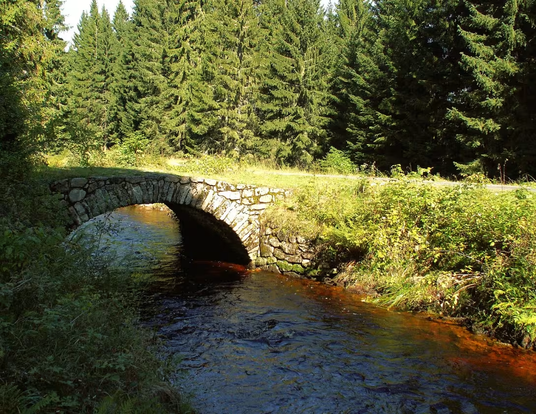

The historical appearance on the left is an AI-generated visualisation and serves as inspiration only.
Historical milestones
- 1799
- Prince Joseph II of Schwarzenberg's decision to build a canal.
- 1799
- Start of construction work on the canal under the direction of engineer Josef Rosenauer.
- 1800
- Completion and deployment of the channel.
- 30th years of the 20th century
- The introduction of water lines for water supply to the hydropower plant Vydra.
Architectural development
The channel was built from natural materials such as granite blocks and balvanized trough. The slide sections have a specific structure with a narrow trough and are protected by stone blocks. Currently, some parts of the channel are covered with concrete plates and wooden structures. In the electricity generation section, modernisation and adaptation were carried out for technical purposes.
Historical events
- 1799
- The beginning of the construction of the canal based on the decision of Prince Josef II of Schwarzenberg.
- 1800
- Completion of the construction of a canal used to effectively sail wood from Šumava forests.
- 30th years of the 20th century
- The introduction of water pipes for water supply to the hydroelectric power plant Vydra at Čeňka's mill.
Owners
{'from _ 1799': 'Schwarzenberg family (Prince Josef II. ze Schwarzenbergu)', 'from _ 2019': {'section for electricity production': 'ČEZ Oz closed investment fund a.s.', 'rest of the canal': 'Czech Republic (Administration of the National Park of Šumava)'}}
Points of interest
- The channel was built in 1799-1800 on the manor of Prince Joseph II of Schwarzenberg as the second great work of navigation on his territory.
- His creator was engineer Josef Rosenauer, who designed engineering solutions for the sailing of wood from mountain areas.
- The first slide of the canal, 540 meters long, converts water 23 meters below and is built from huge extermination granite blocks.
- At present part of the channel is covered with concrete plates and since the 1930s the water has been guided by underground pipes to the power plant Vydra.
Guide
This guide is narrated by a synthetic voice generated by artificial intelligence.
Show guide text
This text was created by artificial intelligence and has not been editorially reviewed. It may contain inaccuracies.
Welcome to the heart of Šumava nature, a place where the power of flowing water and the incredible ingenuity of the human mind are united. You are standing at one of the most important technical units of this region, the Vchynicko- tetto Canal. If you look around you now, you'll probably see a dense green forest and hear the rustling of water going into local terrain. It may seem to you that you are looking at a completely natural mountain flow, but you are actually witnessing a masterpiece created by man to control the untamed power of the mountains and use it to its advantage. This water circuit is not just an ordinary channel; It's a symbol of an era where people started trying to change the landscape to serve economic expansion.
Let us now return together in time, deep into the end of the eighteenth century. Imagine 1799. Shumava was then an impenetrable wilderness, full of dense forests, but it was a huge treasure in the form of wood. For Prince Joseph II of Schwarzenberg, this wood was a key source of wealth, but its transportation from mountain areas was extremely demanding and often impossible. The main hurdle was the irreparable stretch beneath the Antégl area, where the river could not carry heavy trees further into the valley. Here comes the character whose name you must remember - engineer Josef Rosenauer. Based on the decision of Prince Josef II of Schwarzenberg, who approved the construction of this ambitious project in 1799, Rosenauer became the architect of this water work.
Work on the canal was extremely difficult at the time. In 1799 and 1800, hundreds of people tried to dig a path for water in difficult terrain, which was meant to connect the Vedry River to the Křemelna River. The goal was not only to create a new flow, but to build an intelligent system that would circumvent nature's greatest obstacles. The channel you're watching today is less than 14 kilometers, exactly 13.6 kilometers, and its construction was absolutely revolutionary for its time. It's not just a trench; It's a complex engineering system designed to manipulate altitude.
Now pay attention to how the whole work is technically handled. Now if you look at the direction in which the water moves, notice how it adapts to the slope of the terrain. The key to the success of the Rosenauer project was two slide sections. These slide sections were designed to safely and effectively reduce the elevation of the canal, allowing the wood to swim even in places where the normal flow would encounter impermeable obstacles. The first of these slides is really impressive - its length is 540 meters. Imagine the work and the precision it took to create a smooth and functional cruise path in such a steep and wild environment. Each metre of this channel was the result of a precise calculation to minimise the risk of wood being stranded or damaged by the construction itself.
In this context, it is good to consider the character of Prince Joseph II himself from Schwarzenberg. This project was not just a random construction; it was part of a broader strategy for the development of its large estate. Vchynicko-tetovský plavební kanál has become the second major piece of navigation on its territory, which shows his visionary approach to the economy and the huge resources he has invested in the development of Shumava forests. As an engineer, Rosenauer was able to translate these ambitions into a reality that lasted for decades.
The interesting thing is that this water system was not intended for just one era. Although its primary function was the sailing of forest wood, history gradually began to change. Another major transformation took place in the 1930s. People realized that the power of water that the channel can concentrate could serve for something much more modern than just transporting raw materials. At this time, a water pipeline was introduced into the system, which was used to bring water to the hydropower plant Vydra. Thus, the channel became part of a modern energy network and its importance expanded from the forestry sector to the electricity generation sector. This ability to adapt to the new needs of the world is one of the reasons why this place is so fascinating.
Perhaps you are now told how such a work could have been created at the time. Imagine the logistical challenge: how to build a kilometer system in a mountain forest, without modern machinery, that must be waterproof, stable and able to bear the huge impacts of sailing tribes? This required not only deep knowledge of hydraulics, but also incredible organizational ability. Every detail, from the gradient of the terrain to the joining of two flows, had to be thought through to the last detail in order to prevent disasters while sailing.
Today, when you look at this place, you see a combination of history, technology and nature. The channel no longer sails with huge piles of wood as it once did, but its presence in the landscape is still strong. It's like a silent witness to a time when one tried to understand the laws of nature and use them to build prosperity.
I now choose you for further examination. I suggest you continue along the path along the canal and see how water enters the surrounding terrain. Watch how the sounds of the forest change and how the nature of the surrounding landscape changes in the places where the canal was dug out. Every step can lead you to places where you can see with your own eyes the consequences of engineering work. Don't forget to stop and listen quietly to the flowing water that has been telling its story about wood, princes and engineers for over a hundred years. I wish you a beautiful and inspiring walk along these historic trails. Thank you for your attention and enjoy the beauty of Šumava nature.
Frequently asked questions
Is Vchynicko-tetovský plavební kanál open to the public?
Yes, Vchynicko-tetovský plavební kanál is a public landmark.
How do I get to the place by car / public transport?
There are parking places near the canal. The public transport is available from Prague and other urban areas.
How much is the entrance fee and is it paid on the spot?
Payment is made inside the monument.
Is the tour suitable for children and seniors?
Yes, Vchynicko-tetovský plavební kanál is accessible to all age categories. Special tours are available for children.
How long does the tour take?
The tour takes approximately 1 hour.
What are the opening times and booking is required?
The memorial is open from 9: 00 to 5: 00. Reservation is not necessary, but it is recommended for groups over 10 people.
What's interesting in the immediate vicinity?
In the immediate vicinity there is a landscape value valley of the Vltava River. We recommend visiting the nearby villages of Vchynice and Tetov.
For kids
Imagine going back to the past, when our ancestors began to build their first villages and cities. Vchynicko-tetovský plavební kanál didn't exist at the time, but the Ohra and the Vltava rivers were the same as they are today.
Who lived here? What people gathered on the banks of Greece? It was the fishermen who were hunting the fish that were trying to survive here. They were merchants who crossed rivers with their goods. And they were warriors who fought for land and wealth.
Businesses nearby
Do you run a restaurant, accommodation, shop, museum, rental, wellness or other visitor service near this monument? Show yourself directly to the people heading to it — this is how they will see you in the app and on the web:
Nearby
{'natural elements': [{\ 'name': 'National Park Šumava', 'distance': 'on the premises'}, {'name': 'Castle bridge (Rechle)', 'distance': 'beginning of the canal'}, {'name': 'Adam's mountain (1078 m)', 'distance': 'close to the canal'}, 'name': 'Church hill (1100 m)', 'distance': 'close to the canal', 'name' ('name': 'Modrava', 'distance': 'northeastern,' distance ':' Antégl ',' distance ':' northwest, 'cca 3 km'}, 'other monuments' [{'Schwarzenberk', '
Accommodation nearby
Themed route
Thematic cruise route: Water paths and Šumava peaks
1.Vchynicko-tetovský plavební kanál * Type: * Water work and historical technical monument Why? The unique combination of natural and human work - the channel connects Blue to Antégla and is an ideal place for a quiet cruise or walk around its edges. Here you can see the history of Šumava water transport and observe local fauna.
2. Castle bridge (Rechle) * Type: * Architectural landmark * Why? * Symbolic bridge over the channel that connects Srní to the surrounding area. Its construction is typical of Šumava water buildings and offers beautiful views of the water flow. Suitable for a short stop with photos.
3. Adam's Mountain (1078 m) * Type: * View Mountain * Why? * The nearest peak to the canal, where the panorama of the National Park of Šumava and surrounding hills is located. The path is simple and sought for peaceful nature and air saturated with coniferous flavourings.
4. Blue * Type: * History and nature Why? A small village about 5 km from the canal, known for its pond and traditional Šumava houses. Here you can walk around the water tank and visit the local pub where you can taste typical Šumava specialties.
* Recommended method: * The route starts at the Castle Bridge, continues along the canal to Adam's Mountain, where you will return to Blue. The entire journey is approximately 10 km and lasts 3-4 hours.
Seasonal recommendations
Spring Vchynico-aunt channel in the spring months offers magical transformation of nature. The sun illuminates the water surface with golden light, while the surroundings awaken from winter sleep - the birches flourish, wetlands with early spring plants spread around the waterways. The atmosphere is calm, but alive, because the water is starting to warm up and the fauna is waking up. It is convenient to visit a memory early in the morning when the surroundings are still quiet and fearless crowds of tourists. Wear light but protective clothing - umbrella or raincoat never hesitate to take, as spring weather is variable. The best time for a trip is between April and May, when nature flourishes and the canal offers a unique combination of calm and natural beauty.
Summer In the summer months the channel will turn into an attractive destination for lovers of water activities and walks. The sun shines intensively, the water level turns into a mirror that reflects the blue sky and the green surroundings. The atmosphere is alive, as families and cyclists often meet here, using the channel for their trips. In the main summer season, a larger number of visitors should be counted, so it is advisable to come before the crowds gather. Put on light but protective clothing, as the sun can be very intense here. Don't forget the sunscreen and hat to bring you only pleasant experiences.
Autumn Autumn season on the canal is unique to its melancholy charm. The sun is no longer high, the water level becomes the mirror of the silver and golden shades of leaves that crumble at the edge of the canal. The atmosphere is calm and slightly cold as nature prepares for winter. In this period the channel is less visited, allowing visitors to enjoy its beauty in peace. Wear warmer clothes, because temperatures can be cold, and don't forget the umbrella, because the rains are common in this period. The best time to visit is between September and October when nature turns into a unique variety of colors.
Winter The winter channel offers a unique atmosphere as the water level turns into a mirror of white snow and ice formations. The sun shines low here, creating mysterious shadows and reflected in the ice. The atmosphere is calm and quiet, as nature calms and prepares for winter sleep. In this period the channel is less visited, allowing visitors to enjoy its beauty in peace. Wear warm clothes because temperatures can be very low, and don't forget the appropriate shoes to bring you a trip just a pleasant experience. The best time to visit is in January and February when nature turns into a winter fairy tale.
Visualizations and artistic views


The visualisations are generated by artificial intelligence and serve as inspiration.
Atmosphere of the place
This atmospheric visualisation of the place and period was generated by artificial intelligence. It is not real footage of the location.
Tips from visitors
No tips yet. Be the first!
Log in and add your tip.
Sources and literature
Fotografie: Dingoa / CC BY-SA 3.0, rozlišení zvýšeno umělou inteligencí — Wikimedia Commons. The author and licence also appear when you hover over the image.
Faktickým podkladem tohoto textu byl článek na Wikipedii, jehož autory jsou přispěvatelé Wikipedie. Článek je dostupný pod licencí CC BY-SA 4.0.
Location on the map

Příběhy a pověsti
Legendy, pověsti a příběhy spjaté s touto památkou
Fotografie návštěvníků
Zatím žádné fotografie. Buďte první, kdo přidá fotografii z návštěvy!
Přihlaste se a přidejte svou fotografii nebo hodnoťte.
Za ověřenou návštěvu v aplikaci získáte víc bodů — poznáme podle GPS, že jste na místě.
Reviews and comments